Past IEM Features tagged: winter2425
The IEM generates per winter storm analyses of snowfall reports over Iowa and tags them by the winter season. Here are the tags used for the previous winter seasons that these maps are available for:
- Winter 2010-2011
- Winter 2011-2012
- Winter 2012-2013
- Winter 2013-2014
- Winter 2014-2015
- Winter 2015-2016
- Winter 2016-2017
- Winter 2017-2018
- Winter 2018-2019
- Winter 2019-2020
- Winter 2020-2021
- Winter 2021-2022
- Winter 2022-2023
- Winter 2023-2024
- Winter 2024-2025
- Winter 2025-2026
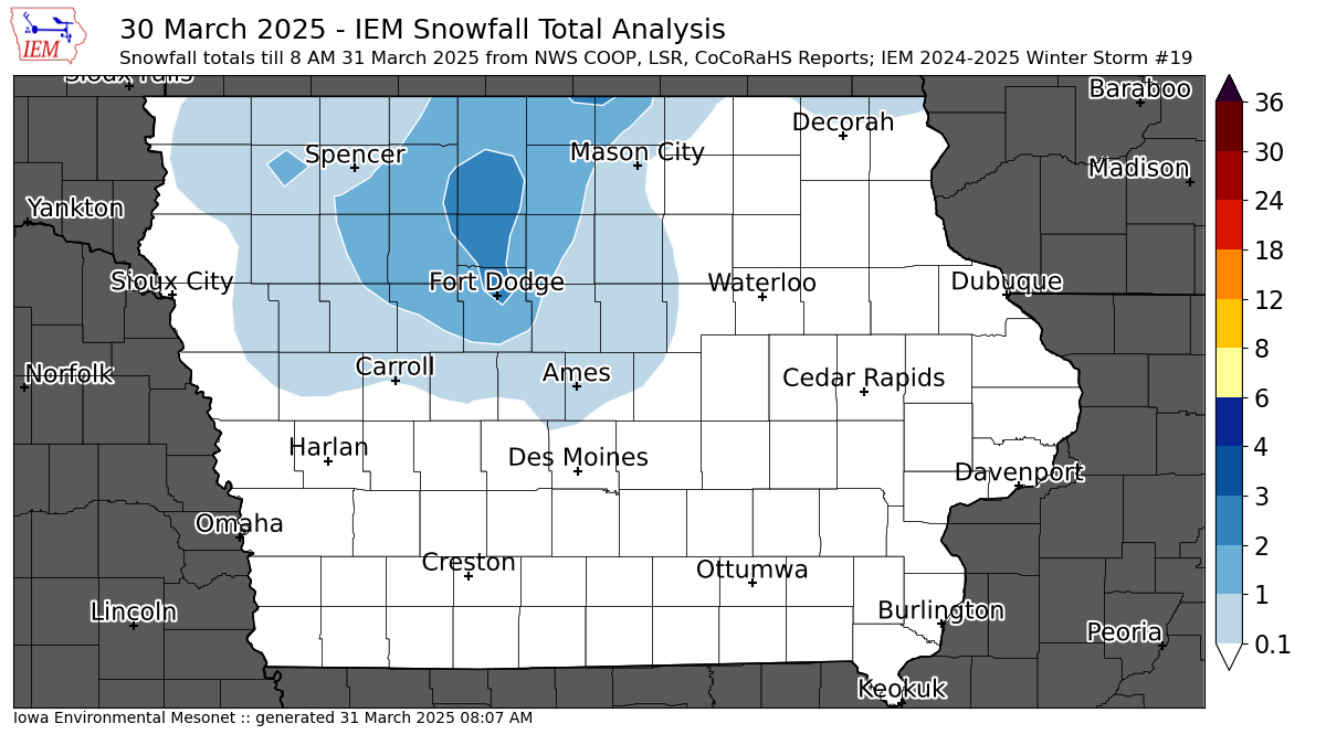
'24-'25 Winter Storm #19
31 Mar 2025 08:12 AMThe month of March has seen a number of large and very powerful storm systems to impact the US. Iowa caught a passing blow from the cold side of the system on Sunday afternoon with most of the snow during the afternoon hours melting as it hit the ground. There was just enough cold air and intense snowfall rates to allow for some accumulation over north central Iowa with a few isolated two inch reports near Fort Dodge. Much worse winter weather was found just to Iowa's north with an expansive area of freezing rain and also to our south with severe weather from Illinois to Louisiana. The active weather pattern will continue with another major storm arriving Tuesday into Wednesday.
Voting:
Good: 12
Bad: 0
Tags: winter2425
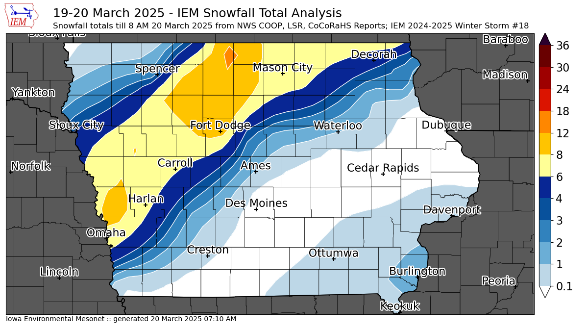
'24-'25 Winter Storm #18
20 Mar 2025 07:16 AMAs with a number of recent Wednesdays, a major winter storm impacted the state. This storm system also featured a number of hail producing storms Wednesday morning with even a couple of instances of having a Severe Thunderstorm Warning coincident with a Blizzard Warning (more on that tomorrow). The featured map presents an analysis of snowfall reports with a few isolated reports of around twelve inches! Thunder-snow was also observed with this event, which weather forecasting lore implies a foot of snow will fall somewhere nearby. Winds were again very extreme with this storm with gusts exceeding 60 MPH for some locations. Mid March sunshine and warmer temperatures will start the melting work today.
Voting:
Good: 15
Bad: 1
Abstain: 1
Tags: winter2425
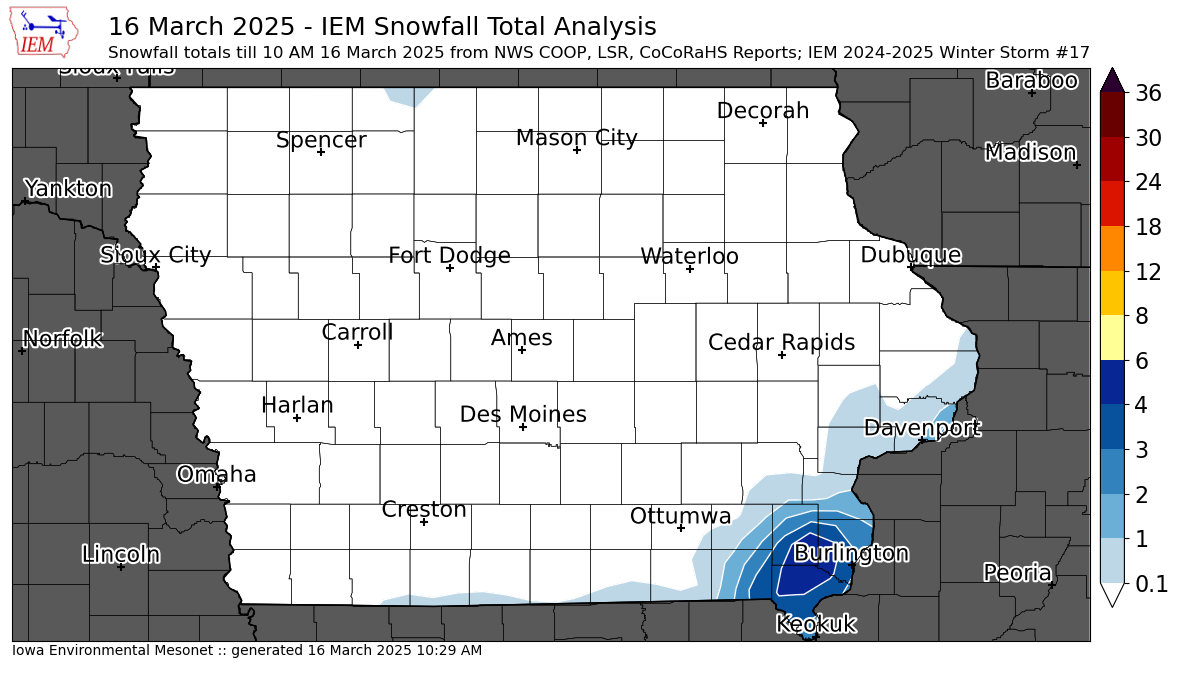
'24-'25 Winter Storm #17
16 Mar 2025 10:36 AMA significant and expansive storm system continues to churn over the Great Lakes region this Sunday morning. This system brought record high temperatures on Friday along with strong winds and severe weather. The backside of the system clipped far southeastern Iowa overnight with a narrow and intense band of snowfall. The featured analysis of available reports show a small area of four plus inches of snow! This snowfall will struggle to survive the day with mid March sunshine typically making quick melting work of snow.
Voting:
Good: 6
Bad: 0
Tags: winter2425
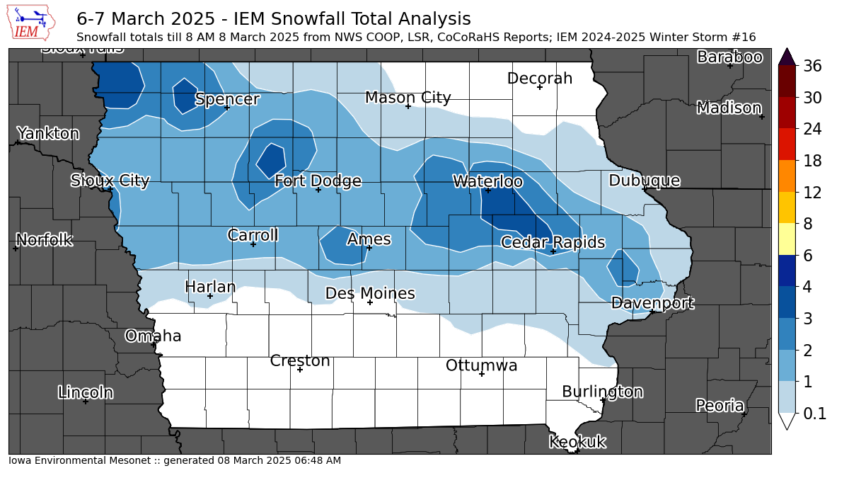
'24-'25 Winter Storm #16
08 Mar 2025 06:57 AMBoth winter storms this week presented significant snowfall measurement challenges. The first was a blizzard with extremely strong winds, so finding an undistributed location to measure a depth was impossible. The storm on Friday mostly fell during the daylight hours and much of it melted as temperatures hovered near the freezing point. So the featured map is again a struggle to accurately represent the depth of snow that fell. The map generally shows a stripe of one to three inches falling from Davenport to the northwestern corner of the state. The ice and snow we accumulated for the week will be melting quickly as warmer temperatures return to the state for the coming week. As an aside, a common Iowa weather folklore tale is that bad winter weather accompanies the Iowa High School Girl's state basketball tournament. That turned out to be the case this year!
Voting:
Good: 5
Bad: 3
Abstain: 4
Tags: winter2425
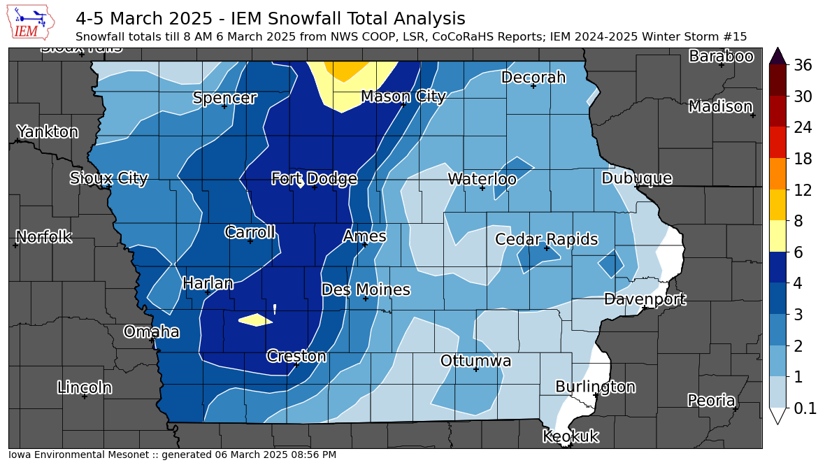
'24-'25 Winter Storm #15
06 Mar 2025 08:09 AMA major winter storm brought high winds, heavy snowfall, blizzard conditions, but also much needed rainfall to the state on Tuesday into Wednesday. Widespread rainfall amounts over an inch were found over much of the state with a quick transition to snow creating treacherous driving as a moisture rich slush froze and was compacted to ice. This system also featured upper echelon wind gusts with numerous locations topping 60 MPH. North central Iowa was particularly hard hit as the featured map shows the highest snowfall totals combined with the strong winds to create impassable snow drifts that will take considerable time to clear. The map analysis of snowfall over eastern Iowa is tricky as snow totals were lighter and the multi-day nature of the event with snow falling during the daytime on Wednesday with melting. Our next winter storm arrives this Thursday evening, but will be no where near as intense as this storm was.
Voting:
Good: 13
Bad: 2
Tags: winter2425
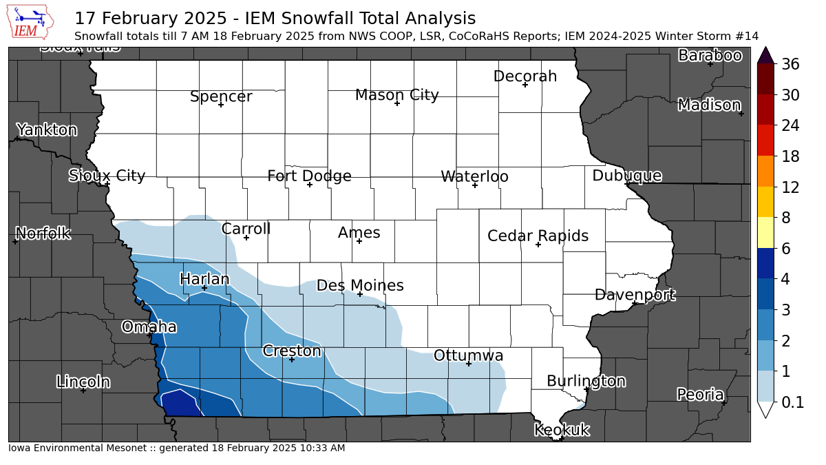
'24-'25 Winter Storm #14
18 Feb 2025 07:00 AMThe snow producing winter storms continue to come at a rapid pace with the most recent system clipping southwestern Iowa with up to four inches of snowfall on Monday. While the snow producing storms look to settle down for Iowa, bitter cold air will be present for the week with overnight lows well below zero and daytime highs struggling in the single digits. The good news, for those that do not like this weather, is that much warmer temperatures are expected next week.
Voting:
Good: 11
Bad: 2
Tags: winter2425

'24-'25 Winter Storm #13
16 Feb 2025 11:18 AMThe third of three snow storms last week came in two ways with accumulating snow falling Friday evening and then again on Saturday. A narrow band of the highest snowfall accumulations was found from just north of Omaha to far northeastern Iowa. The southern end of this stripe of snow had a very tight gradient, which is not well represented by this smoothed analysis. A bit of freezing drizzle was also found with this storm on Saturday over southeastern Iowa. Bitter cold air is once again back over Iowa today and will stick around throughout the week.
Voting:
Good: 13
Bad: 4
Tags: winter2425

'24-'25 Winter Storm 12
13 Feb 2025 08:08 AMThe second of three forecasted winter storms this week brought a healthy amount of snow over much of southern Iowa. The featured map presents an analysis of available NWS and CoCoRaHS reports. The highest totals approached nine to ten inches from a line just north of Ottumwa to just south of Dubuque. Bitter cold air has arrived in the storms wake with almost the entire state below zero this Thursday morning. The third storm arrives this weekend, but totals are not expected to be as large as this most recent storm.
Voting:
Good: 14
Bad: 6
Abstain: 1
Tags: winter2425
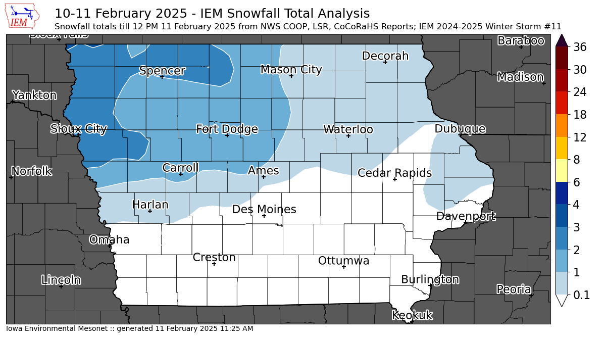
'24-'25 Winter Storm #11
11 Feb 2025 07:58 AMThe first of three snow storms for this week brought a few inches of snow over northwestern Iowa. It also ushered in some bitterly cold air with a breeze creating for cold wind chill temperatures this Tuesday morning. The next snow storm will arrive this evening with the most significant dump of snow over the state so far this season expected. Winter Storm Warnings are in effect for much of the southeastern half of the state with snow totals in the six to eight inch range forecast.
Voting:
Good: 16
Bad: 1
Tags: winter2425
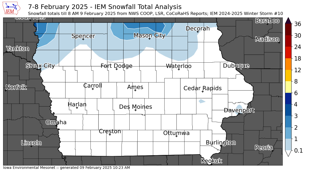
'24-'25 Winter Storm #10
09 Feb 2025 10:27 AMA winter storm just clipped northern Iowa on Friday evening into Saturday with a few isolated totals around three inches. There was some concern over freezing drizzle to the south over much of Iowa, but dry air prevented much of that from materializing. For those folks bummed over the lack of snow this winter, this week looks to make up for lost time with three rounds of accumulating snowfall expected.
Voting:
Good: 22
Bad: 1
Abstain: 1
Tags: winter2425
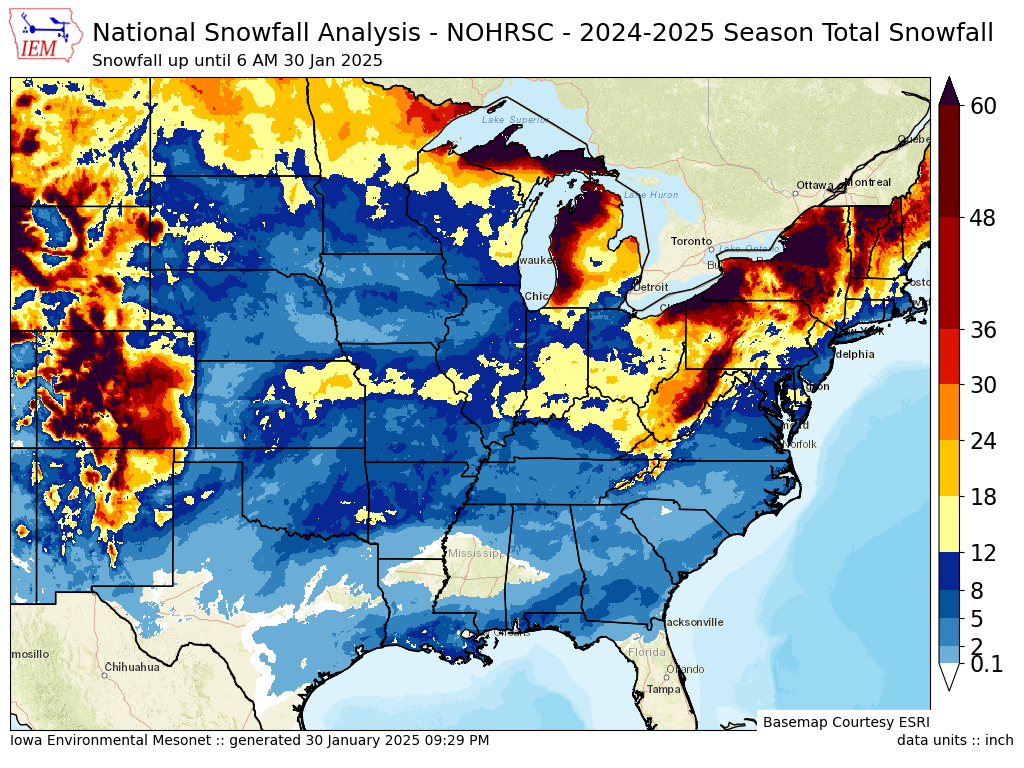
More Snow in All Directions
31 Jan 2025 05:30 AMThe featured map presents a season to date total snowfall analysis from NOHRSC. The snowfall drought over Iowa this season is readily seen with higher season totals found in every direction travelling away from the state! Even more remarkable is to find higher snowfall totals in Louisiana and Florida than can be found in most of Iowa. Such as been the season to date with the most significant winter storms staying off to our south. There is still plenty of time for this pattern to flip, but the present storm today is just dumping needed rainfall and the near term forecast does not have much for snow chances.
Voting:
Good: 30
Bad: 1
Abstain: 3
Tags: winter2425

'24-'25 Winter Storm #9
23 Jan 2025 07:56 AMAfter a daytime on Wednesday of mostly light snowfall amounts, a more robust area of snow setup over eastern Iowa during the early evening hours and a number of locations around Cedar Rapids reported two to four inches of snow. The featured map presents a smoothed analysis of available NWS and CoCoRaHS repors. A cold front swept the state overnight, increasing winds and dropping temperatures with sub zero wind chill readings present over the state this Thursday morning. The good news, for those that do not like the cold, is that temperatures will rebound for the weekend with plenty of above freezing time to start off next week.
Voting:
Good: 12
Bad: 1
Tags: winter2425

'24-'25 Winter Storm #8
15 Jan 2025 05:30 AMWhile not much for a winter storm, an isolated area near Fort Dodge reported the IEM-analysis-map-arbitrary total of at least two inches of snow overnight into Tuesday morning. Totals an inch or less were common over the rest of the state. Other reports of an inch were found in a line from Fort Dodge to Davenport. The forecast continues to show warming temperatures for the rest of this week before a significant cold air outbreak arrives for early next week.
Voting:
Good: 13
Bad: 2
Abstain: 1
Tags: winter2425

'24-'25 Winter Storm #7
06 Jan 2025 08:01 AMA major winter storm brought freezing rain and heavy snow from Kansas to now D.C. Iowa barely got clipped by the event with a sharp northern side gradient to the heaviest snowfall totals as dry air over Iowa fought off the snow. The featured analysis is struggling to show the tight gradient that exists over the southern tier of Iowa counties with a limited number of reports in the area. Our recently active weather pattern looks to settle down a bit this week with seasonal cold air in place and not much in the way of precipitation chances.
Voting:
Good: 13
Bad: 0
Tags: winter2425

'24-'25 Winter Storm #6
02 Jan 2025 10:28 PMA compact and quick moving winter storm dumped a stripe of two to four inches on Thursday between roughly Sioux City to Davenport. The featured map presents an analysis of mostly NWS Local Storm Reports as much of the once-daily COOP data will be arriving Friday morning. So the map will be updated once those additional reports arrive along with any CoCoRaHS reports. The map also plots the three Snow Squall Warnings polygons issued by NWS Des Moines as intense snowfall rates impacted the morning work commute. Attention is quickly turning to a much larger storm complex forecast to arrive late this weekend, with the largest snowfall totals forecast to clip southern Iowa along with a sharp gradient in totals to the north.
Voting:
Good: 19
Bad: 5
Tags: winter2425

'24-'25 Winter Storm #5
01 Jan 2025 12:54 PMWhile most of the precipitation from the storm impacting the state Monday into Tuesday fell as rain, a few locations picked up measurable snowfall with an isolated area west of Des Moines picking up over two inches. The featured map presents available NWS COOP, Local Storm Reports, and CoCoRaHS reports over the past two days. Some of the snow did quickly melt with the change over to rain, so totals were difficult to measure and report. Our weather pattern looks to remain active to start off 2025 with the next accumulating snow storm arriving Thursday and a likely bigger storm to end the upcoming weekend.
Voting:
Good: 13
Bad: 0
Tags: winter2425

'24-'25 Winter Storm #4
20 Dec 2024 08:18 AMA prolonged period of snowfall starting late Wednesday evening brought a few inches of snowfall over the northern tier of Iowa counties. The heaviest totals approaching four inches were found over extreme northeastern Iowa. There additionally was some minor freezing rain with this event as well. Winter Road Conditions are currently partially snow and ice covered this Friday morning over northeastern Iowa. Unfortunately, this snowfall will not stick around for Christmas next week as a number of days with above freezing temperatures are expected for the area.
Voting:
Good: 15
Bad: 1
Abstain: 1
Tags: winter2425

'24-'25 Winter Storm #3
18 Dec 2024 08:20 AMWhile not much for a winter storm, a quick moving system brought some rain, freezing, and snow to mostly the northern half of the state. There were a few isolated two inch snow fall reports found over northeastern Iowa, so the arbitrary threshold for IEM map generation / storm counting was triggered. Another quick moving snow producing storm is expected this evening with similar amounts of light snowfall. For those of you hoping this bit of snowfall sticks around for a week, above freezing temperatures are expected next week and even tomorrow, so the chances of a White Christmas are very slim at the moment.
Voting:
Good: 13
Bad: 0
Tags: winter2425

'24-'24 Winter Storm #2
15 Dec 2024 08:30 PMFriday evening into Saturday brought a significant ice storm to eastern Iowa with the Cedar Rapids to Iowa City corridor the hardest hit. The featured map presents available NWS Local Storm Reports of freezing rain accumulations. The map also plots the extent of the Ice Storm Warnings issued by the NWS for the event. Far northeastern Iowa did also get an inch or so of snowfall along with some freezing rain. Thankfully, temperatures warmed above freezing for much of the state on Saturday and for the entire state on Sunday, which helped to reduce impacts from this event.
Voting:
Good: 19
Bad: 0
Tags: winter2425
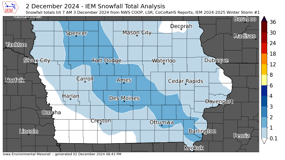
'24-'25 Winter Storm #1
03 Dec 2024 05:30 AMThe first wide spread snowfall over Iowa of the season fell on Monday with most locations picking up 1.5 inches or less. There were a couple of isolated two inch reports, so this met the arbitrary threshold for the IEM to generate a snowfall event map. The featured map presents an analysis of available NWS and CoCoRaHS reports. This snowfall was tremendously fluffy with snow to liquid water equivalent (SWE) ratios around 40 and above. A more typical SWE value in Iowa is closer to 13, so it was certainly not much trouble to shovel such fluff away. You can find more maps like these for previous winters by clicking the winter2425 tag associated with this feature post.
Voting:
Good: 11
Bad: 0
Tags: winter2425