National Weather Service Raw Text Product
Displaying AFOS PIL: LSRDVN Product Timestamp: 2025-06-12 02:54 UTC
Previous in Time Latest Product Next in Time
View All KDVN Products for 12 Jun 2025 View All LSR Products for 12 Jun 2025 View As Image Download As Text
141
NWUS53 KDVN 120254
LSRDVN
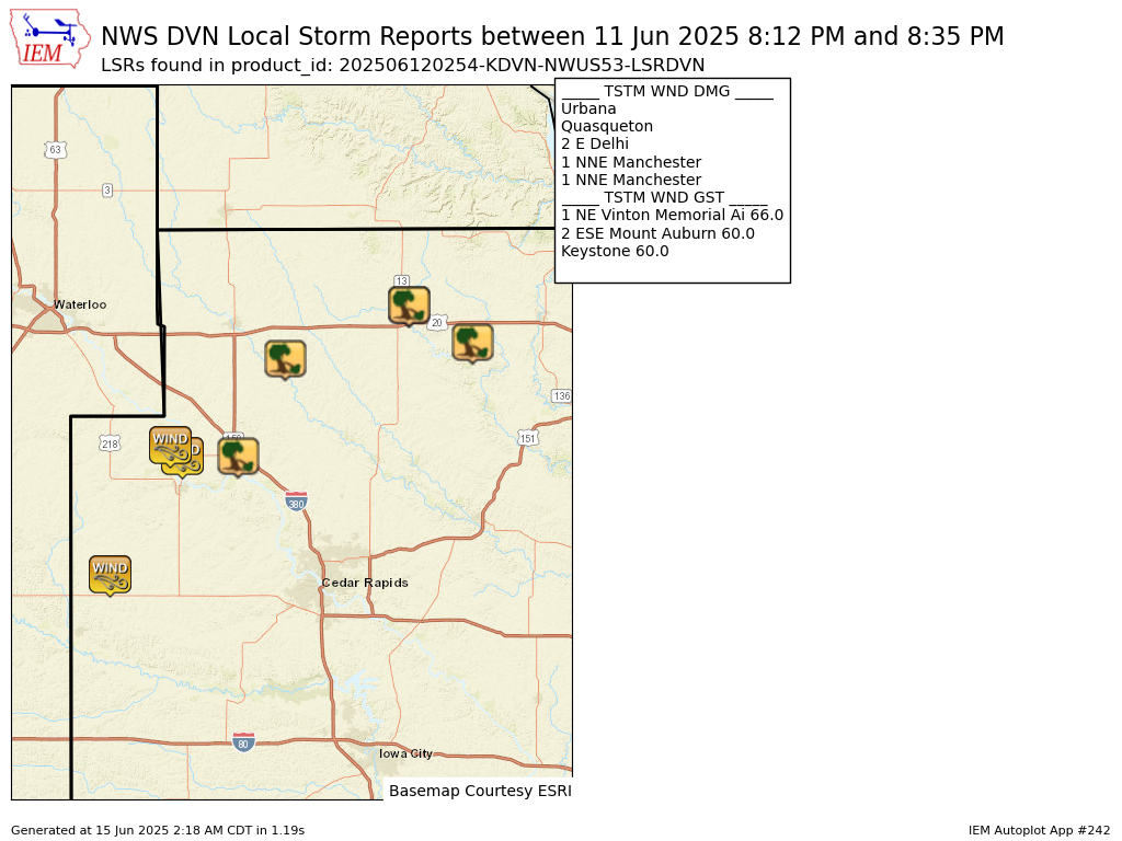
Preliminary Local Storm Report...Summary
National Weather Service Quad Cities IA IL
954 PM CDT Wed Jun 11 2025
..TIME... ...EVENT... ...CITY LOCATION... ...LAT.LON...
..DATE... ....MAG.... ..COUNTY LOCATION..ST.. ...SOURCE....
..REMARKS..
0812 PM Tstm Wnd Dmg Quasqueton 42.40N 91.76W
06/11/2025 Buchanan IA Emergency Mngr
Likely with outflow ahead of the storms.
0815 PM Tstm Wnd Dmg 2 E Delhi 42.43N 91.29W
06/11/2025 Delaware IA Fire Dept/Rescue
Large tree in roadway at 245th St and 260th
Ave east of Delhi. Done by storm outflow
winds well ahead of the storms themselves.
Time estimated by outflow signature on
radar.
0815 PM Tstm Wnd Gst 1 NE Vinton Memorial Ai 42.22N 92.02W
06/11/2025 M66 MPH Benton IA AWOS
AWOS station KVTI Vinton Arpt.
0815 PM Tstm Wnd Gst 2 ESE Mount Auburn 42.24N 92.05W
06/11/2025 E60 MPH Benton IA Trained Spotter
A lot of tree litter being blown around at
time of maximum gusts.
0829 PM Tstm Wnd Dmg 1 NNE Manchester 42.50N 91.45W
06/11/2025 Delaware IA Emergency Mngr
Large lighting pole downed at baseball field
at fairgrounds. With outflow wind gusts well
ahead of storms.
0833 PM Tstm Wnd Gst Keystone 42.00N 92.20W
06/11/2025 E60 MPH Benton IA Trained Spotter
Estimated 60 MPH gust blew over lawn
furniture.
0835 PM Tstm Wnd Dmg Urbana 42.22N 91.88W
06/11/2025 Benton IA Public
Relayed by KCRG TV station. Time estimated
using radar.
&&
$$