National Weather Service Raw Text Product
Displaying AFOS PIL: PNSTOP Product Timestamp: 2022-06-08 18:19 UTC
Previous in Time Latest Product Next in Time
View All KTOP Products for 08 Jun 2022 View All PNS Products for 08 Jun 2022 View As Image Download As Text
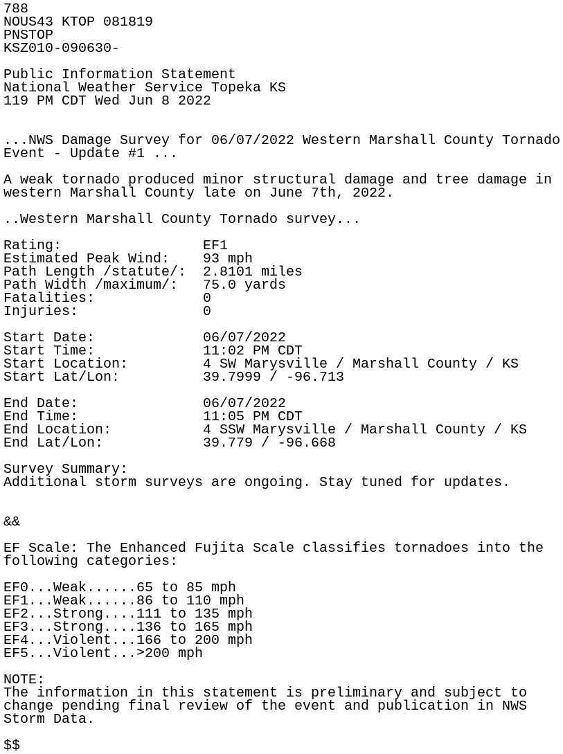
788
NOUS43 KTOP 081819
PNSTOP
KSZ010-090630-

Public Information Statement
National Weather Service Topeka KS
119 PM CDT Wed Jun 8 2022


...NWS Damage Survey for 06/07/2022 Western Marshall County Tornado
Event - Update #1 ...

A weak tornado produced minor structural damage and tree damage in
western Marshall County late on June 7th, 2022.

..Western Marshall County Tornado survey...

Rating:                 EF1
Estimated Peak Wind:    93 mph
Path Length /statute/:  2.8101 miles
Path Width /maximum/:   75.0 yards
Fatalities:             0
Injuries:               0

Start Date:             06/07/2022
Start Time:             11:02 PM CDT
Start Location:         4 SW Marysville / Marshall County / KS
Start Lat/Lon:          39.7999 / -96.713

End Date:               06/07/2022
End Time:               11:05 PM CDT
End Location:           4 SSW Marysville / Marshall County / KS
End Lat/Lon:            39.779 / -96.668

Survey Summary:
Additional storm surveys are ongoing. Stay tuned for updates.


&&

EF Scale: The Enhanced Fujita Scale classifies tornadoes into the
following categories:

EF0...Weak......65 to 85 mph
EF1...Weak......86 to 110 mph
EF2...Strong....111 to 135 mph
EF3...Strong....136 to 165 mph
EF4...Violent...166 to 200 mph
EF5...Violent...>200 mph

NOTE:
The information in this statement is preliminary and subject to
change pending final review of the event and publication in NWS
Storm Data.

$$