Past IEM Features tagged: swe

Plenty of supply
26 Feb 2010 06:17 AMThe featured map displays NOAA modeled snow water equivalent (the depth of liquid water present in the snow pack) for the Des Moines River Basin (red outline) upstream of Saylorville Lake. A crude GIS calculation indicates that there is enough frozen water in the basin to fill Saylorville Lake 2.5 times! Of course, not all of this water will make it downstream into the reservoir, but we will have to be fairly lucky to melt all of this snow without significant flooding. The worst case scenario would be for a heavy rainfall event on top of this extensive snow pack. There is about 550 billion gallons of frozen supply upstream of a reservoir that holds 221 billion gallons.
Voting:
Good: 66
Bad: 23
Tags: flood swe
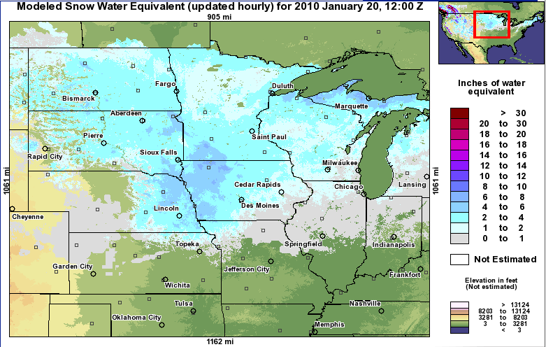
Four inches of water
21 Jan 2010 06:11 AMThe featured map is from the excellent NOAA Hydrologic Remote Sensing Center website showing modeled snow water equivalent from yesterday morning. Think of this as the depth of liquid water stored in the snow pack when melted. Even before up to an inch of freezing rain fell yesterday, this area was analyzed to have around four inches of water stored in the snow pack. The danger is flooding if this were to rapidly melt due to rainfall or warm weather.
Voting:
Good: 26
Bad: 5
Tags: swe
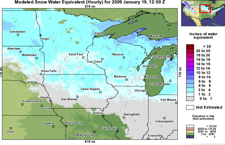
Waiting water
20 Jan 2009 06:11 AMThe featured map is from the excellent NOAA NOHRSC website showing the modeled snow water equivalent. This is simply the depth of liquid water contained in the snow pack. Our lack of days above freezing has allowed the snowfalls to accumulate into a snow pack containing between 2-5 inches of water over the northern half of the state. The hope is for a slow snow melt so that the rivers have a chance to move water downstream. Some melting should occur this week as temperatures are expected to warm above freezing.
Voting:
Good: 31
Bad: 10
Tags: swe