Past IEM Features tagged: frost
Last Hard Freeze
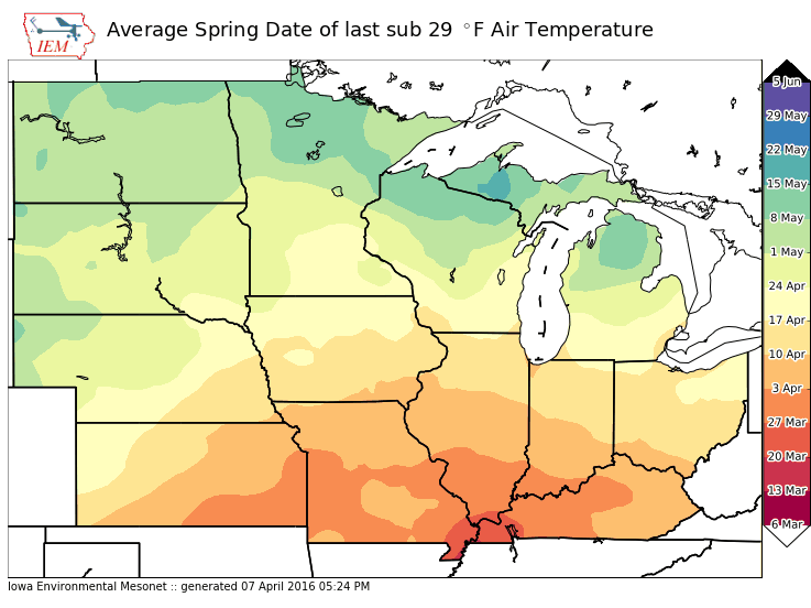
08 Apr 2016 05:34 AMVery chilly air is filtering into Iowa today and is expected to push temperatures well below freezing tonight. With temperatures below 29 degrees Fahrenheit, a hard freeze is expected. Is having such an event during the second week of April uncommon? The featured map displays the average date of last sub 29 degree low temperature for the spring season over the Midwest based on period of record data. Of course, the further south you go, the longer past average date this event would be.
Voting:
Good: 15
Bad: 1
Tags: freeze frost
Frost Advisory
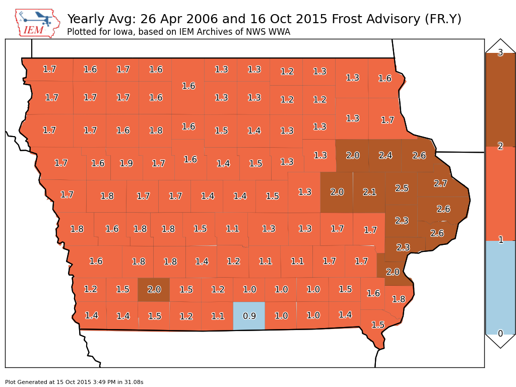
16 Oct 2015 05:34 AMThe coldest weather to date has arrived for Iowa with the NWS issuing Frost Advisories for much of western Iowa. The featured map presents the yearly average frequency of frost advisories since 2006. This alert is typically only issued once or twice in the fall season, but can be issued in the spring for late season cold. Every county is shown above 1 alert per year, except Wayne County. There likely isn't a physical reason for this, but a quirk of how this product is issued by the NWS Offices covering the state. There was no early freeze in the state this year, which was needed to help get crops to maturity.
Voting:
Good: 19
Bad: 25
Abstain: 6
Tags: frost

Morning Frost
21 Jan 2015 05:39 AMHighway frost was a major issue over Iowa on Tuesday morning. The featured chart presents the combination of RWIS air, dew point, and pavement temperatures for US Highway 30 near Jefferson along with the reported road condition by the Iowa State Patrol. The clear issue shown in the chart is having the road temperature below the dew point, which causes deposition of water vapor onto a frozen surface. Once the road temperature raises above the dew point, the frost was gone and the road reported as dry.
Voting:
Good: 14
Bad: 4
Abstain: 3
Tags: frost rwis
Deep Freeze
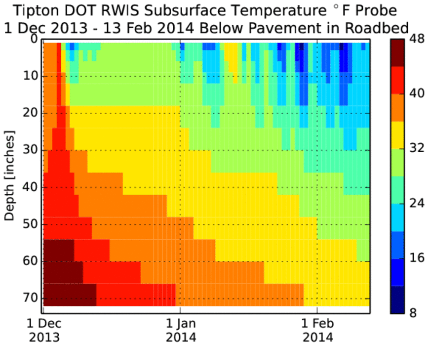
14 Feb 2014 05:40 AMA significant impact of the cold winter season has been an increase in underground water line breaks. These occur when freezing temperatures reach the depth that water pipes are buried. The featured chart displays a time series of average daily subsurface temperatures from the Tipton DOT RWIS site. This site has a probe taking a profile temperature down to 70 inches deep at a six inch interval. Sub-freezing temperatures are indicated down to five feet! The caveat with these readings is that the profile is below a pavement surface, which tends to have more sand / rock than soil. This permits more rapid cooling than underneath a grassy surface. The plot nicely depicts the temporal lag it takes for heat to be lost and temperatures cool, the further down the profile you go.
Voting:
Good: 45
Bad: 6
Abstain: 4
Tags: rwis frost

First Fall Hard Freeze Climatology
14 Dec 2011 05:48 AMHaving air temperatures at or below 28 degrees Fahrenheit are often considered to be a 'killing frost' event. It is not an exact science and very small scale processes occur to kill or protect the plant, anyway the featured chart presents the the frequency of having such a cold temperature by a given date in the fall season. For example, Waukon has seen the first hard freeze roughly 70% of the years prior to 1 November. There is a variation of just around a month from the earliest to latest in the state. In fact, Fort Madison made it till 9 December back in 2001 before hitting such a cold temperature.
Voting:
Good: 23
Bad: 3
Tags: fall frost