Past IEM Features tagged: dec09
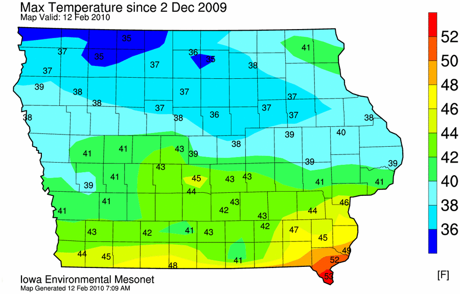
Long time without warmth
12 Feb 2010 06:10 AMThose of you that can recall way back on the first day of December, it was very warm in Iowa that day. Ames hit 60 degrees then. Since then, we have barely reached 40 degrees. The featured map looks at the warmest temperature since the 2nd of December and about only the southern half of the state has seen 40 degree weather in the past 70 some days. The misery looks to continue with more snow and cold forecast for this weekend.
Voting:
Good: 40
Bad: 15
Tags: jan10 dec09
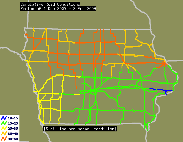
New Normal
09 Feb 2010 04:56 AMThe featured map displays the percentage of time a road segment was reported to be in non-normal condition since the first of December. The orange lines indicate that roughly 40 to 50 percent of the time, the road has required some sort of work by road crews who have put in very long hours this winter. Road conditions will deteriorate today thanks to a strong northwest wind expected to blow the fluffy snow from these past two days around.
Voting:
Good: 22
Bad: 10
Tags: dec09 jan10 roads

Too many spikes
01 Feb 2010 06:09 AMThe featured graph shows an IEM estimate of the areal coverage of NEXRAD reflectivity returns over Iowa for a period dating back to 1 Dec 2009. Each of the spikes in the graph can probably be considered as a storm system impacting the state. Outside of a 10 day period in January where we had lots of fog, there have been plenty of storm systems this winter. Another one is here this Monday morning and expected to bring up to 3 inches of snow for some folks in Northern Iowa.
Voting:
Good: 18
Bad: 4
Tags: jan10 dec09
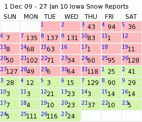
Many snow reports
28 Jan 2010 06:11 AMThe featured chart presents the daily number of NWS COOP network sites in Iowa reporting measurable snowfall since the first of December. The chart nicely shows how active of a winter it has been with snowfall being reporting nearly each day. Please note that these reports are typically at 7 AM for a period consisting of the past 24 hours at that time. The forecast keeps us mostly dry until early next week when our next winter storm arrives.
Voting:
Good: 24
Bad: 4
Tags: dec09 jan10
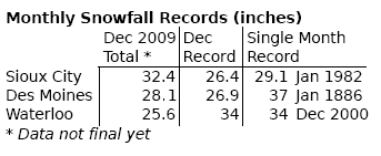
Record December
31 Dec 2009 06:14 AMThe featured image presents preliminary snowfall totals for this December along with the previous record for the month and the all-time monthly record. Sioux City broke their monthly snowfall total record by 3 inches and Des Moines' total places it second all-time. Waterloo did not break either record as their total was well short of the 34 inches back in December 2000. It has been a brutal winter thus far and the next few weeks look to be bitterly cold, but not as snowy.
Voting:
Good: 13
Bad: 9
Tags: dec09 snow