National Weather Service Raw Text Product
Displaying AFOS PIL: SVSDMX Product Timestamp: 2025-03-14 21:37 UTC
Previous in Time Latest Product Next in Time
View All KDMX Products for 14 Mar 2025 View All SVS Products for 14 Mar 2025 View As Image Download As Text
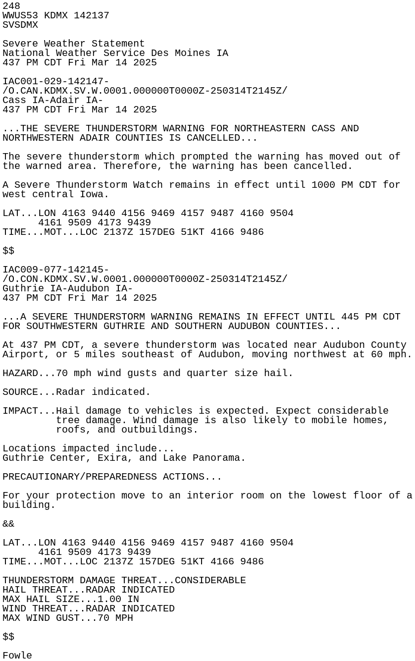
248
WWUS53 KDMX 142137
SVSDMX

Severe Weather Statement
National Weather Service Des Moines IA
437 PM CDT Fri Mar 14 2025

IAC001-029-142147-
/O.CAN.KDMX.SV.W.0001.000000T0000Z-250314T2145Z/
Cass IA-Adair IA-
437 PM CDT Fri Mar 14 2025

...THE SEVERE THUNDERSTORM WARNING FOR NORTHEASTERN CASS AND
NORTHWESTERN ADAIR COUNTIES IS CANCELLED...

The severe thunderstorm which prompted the warning has moved out of
the warned area. Therefore, the warning has been cancelled.

A Severe Thunderstorm Watch remains in effect until 1000 PM CDT for
west central Iowa.

LAT...LON 4163 9440 4156 9469 4157 9487 4160 9504
      4161 9509 4173 9439
TIME...MOT...LOC 2137Z 157DEG 51KT 4166 9486

$$

IAC009-077-142145-
/O.CON.KDMX.SV.W.0001.000000T0000Z-250314T2145Z/
Guthrie IA-Audubon IA-
437 PM CDT Fri Mar 14 2025

...A SEVERE THUNDERSTORM WARNING REMAINS IN EFFECT UNTIL 445 PM CDT
FOR SOUTHWESTERN GUTHRIE AND SOUTHERN AUDUBON COUNTIES...

At 437 PM CDT, a severe thunderstorm was located near Audubon County
Airport, or 5 miles southeast of Audubon, moving northwest at 60 mph.

HAZARD...70 mph wind gusts and quarter size hail.

SOURCE...Radar indicated.

IMPACT...Hail damage to vehicles is expected. Expect considerable
         tree damage. Wind damage is also likely to mobile homes,
         roofs, and outbuildings.

Locations impacted include...
Guthrie Center, Exira, and Lake Panorama.

PRECAUTIONARY/PREPAREDNESS ACTIONS...

For your protection move to an interior room on the lowest floor of a
building.

&&

LAT...LON 4163 9440 4156 9469 4157 9487 4160 9504
      4161 9509 4173 9439
TIME...MOT...LOC 2137Z 157DEG 51KT 4166 9486

THUNDERSTORM DAMAGE THREAT...CONSIDERABLE
HAIL THREAT...RADAR INDICATED
MAX HAIL SIZE...1.00 IN
WIND THREAT...RADAR INDICATED
MAX WIND GUST...70 MPH

$$

Fowle