National Weather Service Raw Text Product
Displaying AFOS PIL: PNSLIX Product Timestamp: 2025-02-16 19:51 UTC
Previous in Time Latest Product Next in Time
View All KLIX Products for 16 Feb 2025 View All PNS Products for 16 Feb 2025 View As Image Download As Text
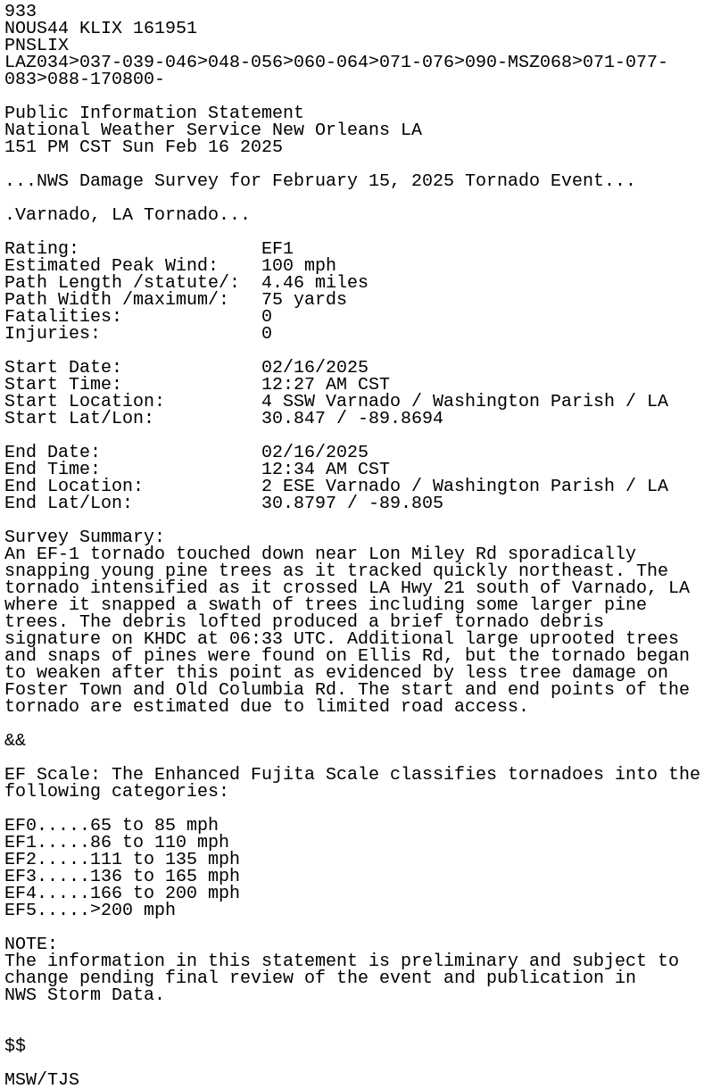
933
NOUS44 KLIX 161951
PNSLIX
LAZ034>037-039-046>048-056>060-064>071-076>090-MSZ068>071-077-
083>088-170800-

Public Information Statement
National Weather Service New Orleans LA
151 PM CST Sun Feb 16 2025

...NWS Damage Survey for February 15, 2025 Tornado Event...

.Varnado, LA Tornado...

Rating:                 EF1
Estimated Peak Wind:    100 mph
Path Length /statute/:  4.46 miles
Path Width /maximum/:   75 yards
Fatalities:             0
Injuries:               0

Start Date:             02/16/2025
Start Time:             12:27 AM CST
Start Location:         4 SSW Varnado / Washington Parish / LA
Start Lat/Lon:          30.847 / -89.8694

End Date:               02/16/2025
End Time:               12:34 AM CST
End Location:           2 ESE Varnado / Washington Parish / LA
End Lat/Lon:            30.8797 / -89.805

Survey Summary:
An EF-1 tornado touched down near Lon Miley Rd sporadically
snapping young pine trees as it tracked quickly northeast. The
tornado intensified as it crossed LA Hwy 21 south of Varnado, LA
where it snapped a swath of trees including some larger pine
trees. The debris lofted produced a brief tornado debris
signature on KHDC at 06:33 UTC. Additional large uprooted trees
and snaps of pines were found on Ellis Rd, but the tornado began
to weaken after this point as evidenced by less tree damage on
Foster Town and Old Columbia Rd. The start and end points of the
tornado are estimated due to limited road access.

&&

EF Scale: The Enhanced Fujita Scale classifies tornadoes into the
following categories:

EF0.....65 to 85 mph
EF1.....86 to 110 mph
EF2.....111 to 135 mph
EF3.....136 to 165 mph
EF4.....166 to 200 mph
EF5.....>200 mph

NOTE:
The information in this statement is preliminary and subject to
change pending final review of the event and publication in
NWS Storm Data.


$$

MSW/TJS