National Weather Service Raw Text Product
Displaying AFOS PIL: PNSLCH Product Timestamp: 2024-12-31 18:11 UTC
Previous in Time Latest Product Next in Time
View All KLCH Products for 31 Dec 2024 View All PNS Products for 31 Dec 2024 View As Image Download As Text
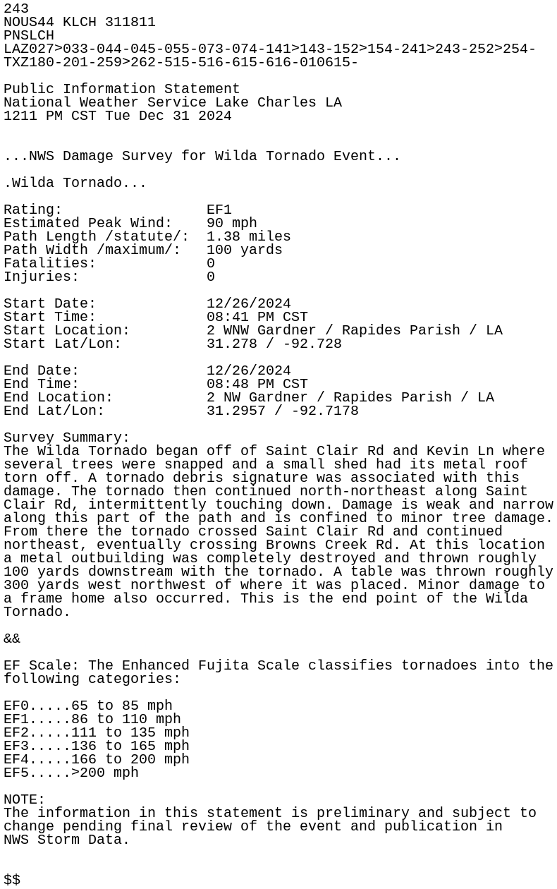
243
NOUS44 KLCH 311811
PNSLCH
LAZ027>033-044-045-055-073-074-141>143-152>154-241>243-252>254-
TXZ180-201-259>262-515-516-615-616-010615-

Public Information Statement
National Weather Service Lake Charles LA
1211 PM CST Tue Dec 31 2024


...NWS Damage Survey for Wilda Tornado Event...

.Wilda Tornado...

Rating:                 EF1
Estimated Peak Wind:    90 mph
Path Length /statute/:  1.38 miles
Path Width /maximum/:   100 yards
Fatalities:             0
Injuries:               0

Start Date:             12/26/2024
Start Time:             08:41 PM CST
Start Location:         2 WNW Gardner / Rapides Parish / LA
Start Lat/Lon:          31.278 / -92.728

End Date:               12/26/2024
End Time:               08:48 PM CST
End Location:           2 NW Gardner / Rapides Parish / LA
End Lat/Lon:            31.2957 / -92.7178

Survey Summary:
The Wilda Tornado began off of Saint Clair Rd and Kevin Ln where
several trees were snapped and a small shed had its metal roof
torn off. A tornado debris signature was associated with this
damage. The tornado then continued north-northeast along Saint
Clair Rd, intermittently touching down. Damage is weak and narrow
along this part of the path and is confined to minor tree damage.
From there the tornado crossed Saint Clair Rd and continued
northeast, eventually crossing Browns Creek Rd. At this location
a metal outbuilding was completely destroyed and thrown roughly
100 yards downstream with the tornado. A table was thrown roughly
300 yards west northwest of where it was placed. Minor damage to
a frame home also occurred. This is the end point of the Wilda
Tornado.

&&

EF Scale: The Enhanced Fujita Scale classifies tornadoes into the
following categories:

EF0.....65 to 85 mph
EF1.....86 to 110 mph
EF2.....111 to 135 mph
EF3.....136 to 165 mph
EF4.....166 to 200 mph
EF5.....>200 mph

NOTE:
The information in this statement is preliminary and subject to
change pending final review of the event and publication in
NWS Storm Data.


$$