National Weather Service Raw Text Product
Displaying AFOS PIL: SPSFFC Product Timestamp: 2024-07-31 20:45 UTC
Previous in Time Latest Product Next in Time
View All KFFC Products for 31 Jul 2024 View All SPS Products for 31 Jul 2024 View As Image Download As Text
127
WWUS82 KFFC 312045
SPSFFC
Special Weather Statement
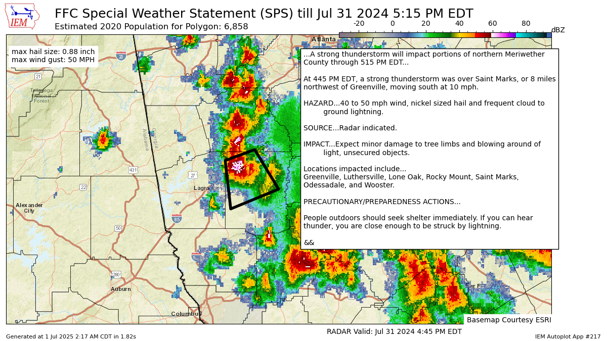
National Weather Service Peachtree City GA
445 PM EDT Wed Jul 31 2024
GAZ067-312115-
Meriwether GA-
445 PM EDT Wed Jul 31 2024
...A strong thunderstorm will impact portions of northern Meriwether
County through 515 PM EDT...
At 445 PM EDT, a strong thunderstorm was over Saint Marks, or 8 miles
northwest of Greenville, moving south at 10 mph.
HAZARD...40 to 50 mph wind, nickel sized hail and frequent cloud to
ground lightning.
SOURCE...Radar indicated.
IMPACT...Expect minor damage to tree limbs and blowing around of
light, unsecured objects.
Locations impacted include...
Greenville, Luthersville, Lone Oak, Rocky Mount, Saint Marks,
Odessadale, and Wooster.
PRECAUTIONARY/PREPAREDNESS ACTIONS...
People outdoors should seek shelter immediately. If you can hear
thunder, you are close enough to be struck by lightning.
&&
LAT...LON 3318 8486 3323 8470 3305 8457 3296 8483
TIME...MOT...LOC 2045Z 340DEG 8KT 3314 8478
MAX HAIL SIZE...0.88 IN
MAX WIND GUST...50 MPH
$$
Autoplot 217 generated the following image below. You may find more customization options , like removal of RADAR, for this image by visiting that autoplot.
