National Weather Service Raw Text Product
Displaying AFOS PIL: PNSDMX Product Timestamp: 2024-07-16 16:56 UTC
Previous in Time Latest Product Next in Time
View All KDMX Products for 16 Jul 2024 View All PNS Products for 16 Jul 2024 View As Image Download As Text
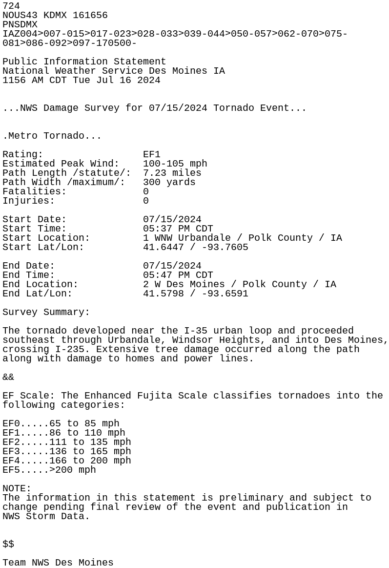
724
NOUS43 KDMX 161656
PNSDMX
IAZ004>007-015>017-023>028-033>039-044>050-057>062-070>075-
081>086-092>097-170500-

Public Information Statement
National Weather Service Des Moines IA
1156 AM CDT Tue Jul 16 2024


...NWS Damage Survey for 07/15/2024 Tornado Event...


.Metro Tornado...

Rating:                 EF1
Estimated Peak Wind:    100-105 mph
Path Length /statute/:  7.23 miles
Path Width /maximum/:   300 yards
Fatalities:             0
Injuries:               0

Start Date:             07/15/2024
Start Time:             05:37 PM CDT
Start Location:         1 WNW Urbandale / Polk County / IA
Start Lat/Lon:          41.6447 / -93.7605

End Date:               07/15/2024
End Time:               05:47 PM CDT
End Location:           2 W Des Moines / Polk County / IA
End Lat/Lon:            41.5798 / -93.6591

Survey Summary:

The tornado developed near the I-35 urban loop and proceeded
southeast through Urbandale, Windsor Heights, and into Des Moines,
crossing I-235. Extensive tree damage occurred along the path
along with damage to homes and power lines.

&&

EF Scale: The Enhanced Fujita Scale classifies tornadoes into the
following categories:

EF0.....65 to 85 mph
EF1.....86 to 110 mph
EF2.....111 to 135 mph
EF3.....136 to 165 mph
EF4.....166 to 200 mph
EF5.....>200 mph

NOTE:
The information in this statement is preliminary and subject to
change pending final review of the event and publication in
NWS Storm Data.


$$

Team NWS Des Moines