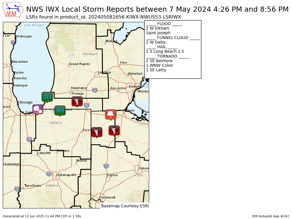
National Weather Service Raw Text Product
Displaying AFOS PIL: LSRIWX Product Timestamp: 2024-05-08 16:56 UTC
Previous in Time Latest Product Next in Time
View All KIWX Products for 08 May 2024 View All LSR Products for 08 May 2024 View As Image Download As Text
293
NWUS53 KIWX 081656
LSRIWX
Preliminary Local Storm Report...Summary
National Weather Service Northern Indiana
1256 PM EDT Wed May 8 2024
..TIME... ...EVENT... ...CITY LOCATION... ...LAT.LON...
..DATE... ....MAG.... ..COUNTY LOCATION..ST.. ...SOURCE....
..REMARKS..
0330 PM Tstm Wnd Dmg 3 WSW Michigan City 41.70N 86.93W
05/07/2024 La Porte IN NWS Storm Survey
Corrects previous tornado report from 3 WSW
Michigan City. A storm survey of the area
near Town of Pines found vehicle and tree
damage consistent with a microburst as well
as from large hail.
0415 PM Hail Michigan City 41.72N 86.88W
05/07/2024 E3.50 Inch La Porte IN Public
0420 PM Hail 1 S Michigan City 41.70N 86.88W
05/07/2024 M2.00 Inch La Porte IN Public
0420 PM Hail 1 S Michigan City 41.70N 86.88W
05/07/2024 M2.00 Inch La Porte IN Trained Spotter
0422 PM Hail 1 NW Michigan City 41.72N 86.89W
05/07/2024 M1.75 Inch La Porte IN Trained Spotter
0423 PM Hail Michigan City 41.72N 86.88W
05/07/2024 M2.50 Inch La Porte IN Trained Spotter
0426 PM Hail 1 S Long Beach 41.74N 86.86W
05/07/2024 M2.50 Inch La Porte IN Public
Reported by Trained Spotter.
0428 PM Hail 1 W Michiana Shores 41.75N 86.83W
05/07/2024 M1.00 Inch La Porte IN Trained Spotter
0438 PM Hail New Buffalo 41.79N 86.74W
05/07/2024 M1.00 Inch Berrien MI Trained Spotter
0500 PM Hail Berrien Springs 41.95N 86.34W
05/07/2024 M1.00 Inch Berrien MI Public
Delayed report.
0500 PM Hail Michigan City 41.71N 86.88W
05/07/2024 M3.00 Inch La Porte IN Public
Hail damage to vehicles in downtown Michigan
City. Public report of 2 to 2.5 inch
hailstones.
0511 PM Flood Saint Joseph 42.10N 86.49W
05/07/2024 Berrien MI Public
Corrects previous flood report from Saint
Joseph. Delayed report of street flooding in
downtown Saint Joseph, MI on the 300 block
of Main Street.
0513 PM Lightning Dowagiac 41.98N 86.11W
05/07/2024 Cass MI Public
Time estimated by radar. Photo on Facebook
shows the Ramona Skating Rink in Dowagiac on
fire. Public reports states that the rink
was hit by lightning, caught fire, and and
burned down.
0515 PM Tornado 4 NE Dowagiac 42.03N 86.05W
05/07/2024 Cass MI Public
Photos on Facebook show heavy tree damage
near Twin Lakes, just northeast of Dowagiac.
Numerous trees of varying sizes snapped or
uprooted. Time estimated by radar.
0515 PM Tornado 3 NE Dowagiac 42.02N 86.07W
05/07/2024 Cass MI Public
Time estimated by radar. Facebook photo
shows two center pivots flipped and damaged.
At the intersection of Atwood Road and Gage
Street.
0516 PM Flood 2 W Elkhart 41.70N 86.00W
05/07/2024 Elkhart IN Public
Report from mPING: Street/road flooding;
Street/road closed.
0530 PM Hail Three Rivers 41.94N 85.63W
05/07/2024 E1.50 Inch St. Joseph MI Public
Delayed report. Time estimated by radar.
0543 PM Tornado 1 ESE Wasepi 41.94N 85.45W
05/07/2024 St. Joseph MI Public
Photo on Facebook of a large tornado on the
ground between Centreville and Colon, just
north of Nottawa. Time estimated by radar.
0550 PM Tornado 3 ESE Mendon 41.99N 85.41W
05/07/2024 St. Joseph MI Trained Spotter
0550 PM Tornado Colon 41.96N 85.32W
05/07/2024 St. Joseph MI Trained Spotter
Corrects time of previous tornado report
from Colon. Trained spotter recorded video
of a large cone tornado in Colon.
0550 PM Tornado Colon 41.96N 85.32W
05/07/2024 St. Joseph MI Trained Spotter
Damage to a home and trees snapped in Colon.
Time estimated by TDS on radar.
0550 PM Hail 1 N Dewey Lake 42.07N 86.19W
05/07/2024 E1.00 Inch Cass MI Public
Report from mPING: Quarter (1.00 in.).
0552 PM Tornado Colon 41.96N 85.32W
05/07/2024 St. Joseph MI Trained Spotter
Trees snapped near Colon, likely from a
tornado. Photos sent in by a trained
spotter. Confirmed TDS on radar. Time
estimated by radar.
0553 PM Tornado 1 WNW Colon 41.97N 85.34W
05/07/2024 St. Joseph MI Amateur Radio
Corrects previous tstm wnd dmg report from 1
WNW Colon. Reports of trees down and farm
damage on Farrand Rd, west of the
roundabout.
0556 PM Hail 2 NNW Fairfax 41.98N 85.38W
05/07/2024 M1.75 Inch St. Joseph MI Trained Spotter
0600 PM Tornado Mendon 42.01N 85.45W
05/07/2024 St. Joseph MI Broadcast Media
Photo of a tornado in Mendon and time of
occurrence relayed by broadcast media.
Several photos from X/Twitter show a large
tornado on the ground in and near Mendon MI.
0600 PM Tornado Leonidas 42.02N 85.35W
05/07/2024 St. Joseph MI Broadcast Media
Tree damage reported in Leonidas by
broadcast media.
0600 PM Tornado Leonidas 42.03N 85.35W
05/07/2024 St. Joseph MI Trained Spotter
Tree damage near Glenwood.
0600 PM Tornado Sherwood 42.00N 85.24W
05/07/2024 Branch MI Trained Spotter
Tornado damage in Sherwood along Arney Road
relayed by trained spotters. Trees snapped
and damage to at least one house. Time
estimated from radar.
0600 PM Tornado Sherwood 42.00N 85.24W
05/07/2024 Branch MI Trained Spotter
Video of debris being lofted in Sherwood.
Time estimated by TDS on radar. Relayed by
trained spotter.
0600 PM Hail Leonidas 42.02N 85.35W
05/07/2024 M2.50 Inch St. Joseph MI Broadcast Media
Pictures shared of up to tennis ball size
hail.
0608 PM Hail Leonidas 42.02N 85.35W
05/07/2024 M4.00 Inch St. Joseph MI Broadcast Media
Photo on X/Twitter shows a 4 inch diameter
hailstone!.
0611 PM Tornado 2 N Silver Lake 41.66N 85.07W
05/07/2024 Steuben IN NWS Storm Survey
Numerous reports of a funnel cloud were
received from west of Angola to north of
Angola including in the area of Crooked and
Loon lakes. Video footage confirms a brief
touchdown north of W 100 N and west of W
Landis Road, likely over an open field. No
damage was found in the area, resulting in a
EF-U rating.
0611 PM Hail Union City 42.07N 85.14W
05/07/2024 E4.00 Inch Branch MI Trained Spotter
Picture shared on twitter of hail stone
measuring upwards of 4 inches.
0612 PM Tstm Wnd Dmg 2 E Laketon 40.98N 85.79W
05/07/2024 Wabash IN Amateur Radio
Report of 3 damaged residences, roof off one
of them, as well uprooted trees and power
lines down. On state route 13 between 1000
and 1100 north.
0615 PM Tstm Wnd Dmg North Manchester 41.01N 85.78W
05/07/2024 Wabash IN Public
Video on Facebook shows powerlines snapped
on State Road 13. Also a report half a mile
down the road of a barn destroyed.
0615 PM Tstm Wnd Dmg North Manchester 41.01N 85.77W
05/07/2024 Wabash IN Public
Large tree branches snapped in North
Manchester (estimated 6-12 inches in
diameter).
0617 PM Hail Coldwater 41.94N 85.00W
05/07/2024 M1.50 Inch Branch MI Trained Spotter
0622 PM Tstm Wnd Dmg Fairmount 40.42N 85.65W
05/07/2024 Grant IN Trained Spotter
Powerlines down. Some roads are being
blocked off.
0622 PM Hail 1 SSE Jonesboro 40.46N 85.62W
05/07/2024 E1.00 Inch Grant IN Trained Spotter
Also recorded a 51 mph gust on an
anemometer.
0625 PM Tstm Wnd Dmg 1 SW Logansport 40.74N 86.37W
05/07/2024 Cass IN Emergency Mngr
Large tree limbs down. Time estimated by
radar.
0626 PM Tstm Wnd Dmg 2 E Goblesville 41.00N 85.47W
05/07/2024 Huntington IN Public
Minor limb damage.
0627 PM Tstm Wnd Dmg South Whitley 41.09N 85.63W
05/07/2024 Whitley IN Public
Time estimated by radar. Barn downed in
South Whitley.
0627 PM Tstm Wnd Dmg South Whitley 41.09N 85.63W
05/07/2024 Whitley IN Public
Barn downed in South Whitley. Unknown how
strong wind speeds were. Time estimated by
radar.
0627 PM Hail 1 S North Manchester 40.99N 85.77W
05/07/2024 E1.00 Inch Wabash IN Public
0634 PM Tstm Wnd Dmg 1 W Columbia City 41.16N 85.50W
05/07/2024 Whitley IN Public
Time estimated by radar. Large tree snapped
in Columbia City, Estimated 12 to 18 inches
in diameter.
0635 PM Tstm Wnd Dmg Larwill 41.18N 85.62W
05/07/2024 Whitley IN Public
Photos on Facebook shows several barns
damaged in Larwill. Time estimated from
radar.
0635 PM Tstm Wnd Dmg Columbia City 41.16N 85.48W
05/07/2024 Whitley IN Public
Time estimated by radar. Photo on Facebook
of a large tree snapped at the base in
Columbia City. Estimated to be 1 to 2 feet
in diameter.
0650 PM Hail Kendallville 41.44N 85.27W
05/07/2024 E3.00 Inch Noble IN Public
0650 PM Hail 1 N Fort Wayne 41.09N 85.14W
05/07/2024 M0.88 Inch Allen IN Amateur Radio
Nickel sized hail lasted for 7 minutes near
Main Street and Wayne Street.
0652 PM Tstm Wnd Dmg 3 N Green Center 41.35N 85.36W
05/07/2024 Noble IN NWS Employee
Delayed report and time estimated by radar.
Several healthy tree branches around 12in in
diameter broken and a couple more uprooted
just west of N 350 E. Also hail damage to
house siding with numerous pock marks/dents.
0653 PM Hail Avilla 41.36N 85.24W
05/07/2024 M1.00 Inch Noble IN Trained Spotter
Hail occurred between 6:50 and 6:55 PM.
0654 PM Hail 2 W Lisbon 41.41N 85.29W
05/07/2024 M1.75 Inch Noble IN Trained Spotter
0655 PM Tstm Wnd Dmg Albion 41.40N 85.42W
05/07/2024 Noble IN Broadcast Media
Time estimated by radar. Large tree,
estimated 1 to 2 feet in diameter, uprooted
in Albion.
0655 PM Hail Kendallville 41.44N 85.26W
05/07/2024 M3.00 Inch Noble IN Public
Damage to cars, windows, and siding on homes
in Kendallville due to hailstones up to 3
inches in diameter.
0657 PM Hail Corunna 41.44N 85.14W
05/07/2024 E1.75 Inch De Kalb IN Public
Time estimated by radar.
0700 PM Hail 1 N Hudson 41.54N 85.08W
05/07/2024 M1.00 Inch Steuben IN Amateur Radio
0705 PM Hail Kendallville 41.45N 85.26W
05/07/2024 M3.00 Inch Noble IN Public
Several 3 inch hailstones per Facebook
reports.
0705 PM Hail Corunna 41.44N 85.14W
05/07/2024 M3.00 Inch De Kalb IN Public
Hail damage reported in Corunna to car,
siding, and roofs. Hailstones up to 3 inches
in diameter fell. Time estimated by radar.
0709 PM Hail 1 NE Hudson 41.54N 85.07W
05/07/2024 E2.50 Inch Steuben IN Public
Time estimated from radar.
0709 PM Hail Hudson 41.53N 85.08W
05/07/2024 M3.00 Inch Steuben IN Emergency Mngr
Time estimated by radar.
0712 PM Hail Pleasant Lake 41.58N 85.02W
05/07/2024 M1.75 Inch Steuben IN Trained Spotter
0715 PM Hail 1 S Angola 41.63N 85.00W
05/07/2024 M1.75 Inch Steuben IN Trained Spotter
0718 PM Hail Ashley 41.53N 85.07W
05/07/2024 M3.00 Inch De Kalb IN Public
Facebook photo of several 3 inch hailstones.
0722 PM Hail Ashley 41.53N 85.07W
05/07/2024 M3.50 Inch De Kalb IN Public
0725 PM Hail Kendallville 41.45N 85.26W
05/07/2024 M3.50 Inch Noble IN Public
Delayed report. Report from mPING: Baseball
(3.50 in.).
0743 PM Hail Hillsdale 41.93N 84.64W
05/07/2024 M1.75 Inch Hillsdale MI Public
Time estimated from radar.
0755 PM Funnel Cloud Paulding 41.14N 84.58W
05/07/2024 Paulding OH Public
Facebook photo of a funnel cloud. Tim
estimated by radar.
0806 PM Tornado 1 SE Latty 41.08N 84.58W
05/07/2024 Paulding OH Public
Small to medium Limbs downed.
0808 PM Tornado 1 W Charloe 41.13N 84.46W
05/07/2024 Paulding OH Emergency Mngr
Van Wert County EMA relayed a photo of a
tornado. Further investigation confirmed
this damaged the house of a relative. Time
estimated.
0813 PM Tornado Oakwood 41.09N 84.39W
05/07/2024 Paulding OH Trained Spotter
Report of tornado with visible soil lofted
along Highway 613 west of Oakwood.
0830 PM Funnel Cloud Melrose 41.09N 84.42W
05/07/2024 Paulding OH Public
Video of a funnel cloud on X/Twitter from
Melrose, OH. Time estimated by radar.
0830 PM Funnel Cloud Broughton 41.09N 84.54W
05/07/2024 Paulding OH Public
Facebook photos shows a funnel cloud nearly
on the ground in Broughton. Time estimated
by radar.
0834 PM Funnel Cloud 2 W Delta 41.59N 84.04W
05/07/2024 Fulton OH Public
Delayed Report.
0836 PM Tornado 2 E Oakwood 41.09N 84.34W
05/07/2024 Putnam OH Public
Photo on X/Twitter between Melrose and
Leipsic of a tornado on the ground. Time
estimated by radar.
0840 PM Tornado Oakwood 41.09N 84.38W
05/07/2024 Paulding OH Public
Numerous photos on Facebook of a funnel
cloud nearly on the ground between Melrose
and Oakwood. Additional photos show the
tornado on the ground near Oakwood. Fairly
certain that a brief tornado touched down
between Melrose and Oakwood. Time estimated
by radar.
0856 PM Tornado 2 SE Belmore 41.13N 83.91W
05/07/2024 Putnam OH Public
Trained spotter observed a very brief
tornado about 2 miles SSE of Belmore. A
friend closer to the storm confirmed it
visually on the ground for a few seconds.
&&
$$