National Weather Service Raw Text Product
Displaying AFOS PIL: LSRMKX Product Timestamp: 2024-02-09 07:00 UTC
Previous in Time Latest Product Next in Time
View All KMKX Products for 09 Feb 2024 View All LSR Products for 09 Feb 2024 View As Image Download As Text
957
NWUS53 KMKX 090700
LSRMKX
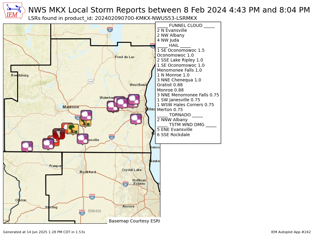
Preliminary Local Storm Report...Summary
National Weather Service Milwaukee/Sullivan WI
100 AM CST Fri Feb 9 2024
...Summary of Severe Weather Report from February 8, 2024...
..TIME... ...EVENT... ...CITY LOCATION... ...LAT.LON...
..DATE... ....MAG.... ..COUNTY LOCATION..ST.. ...SOURCE....
..REMARKS..
0443 PM Hail Gratiot 42.57N 90.02W
02/08/2024 E0.88 inch Lafayette WI Broadcast Media
Relayed by Broadcast Media.
0510 PM Hail Monroe 42.60N 89.64W
02/08/2024 E0.88 inch Green WI Trained Spotter
0526 PM Hail 1 N Monroe 42.61N 89.64W
02/08/2024 E1.00 inch Green WI Public
0533 PM Funnel Cloud 4 NW Juda 42.64N 89.55W
02/08/2024 Green WI Trained Spotter
Multiple reports of funnel clouds near HWY
59.
0535 PM Funnel Cloud 2 NW Albany 42.73N 89.46W
02/08/2024 Green WI Public
Report of funnel moving northeast.
0537 PM Tornado 2 NNW Albany 42.74N 89.45W
02/08/2024 Green WI Public
Reports of tornado on the ground tracking
northeast on the north side of Albany.
0541 PM Funnel Cloud 2 N Evansville 42.81N 89.30W
02/08/2024 Rock WI Public
Reports of a funnel near Footville. Base of
the funnel was blocked by trees, but there
is reports of debris above the tree line.
0600 PM Tstm Wnd Dmg 5 ENE Evansville 42.80N 89.20W
02/08/2024 Rock WI Public
Reports of roof damage and large trees
snapped.
0609 PM Hail 2 SSE Lake Ripley 42.98N 88.96W
02/08/2024 M1.00 inch Jefferson WI Public
Delayed report via social media.
0620 PM Hail 1 SW Janesville 42.67N 89.03W
02/08/2024 E0.75 inch Rock WI Public
Report from mPING. Delayed report.
0620 PM Tstm Wnd Dmg 6 SSE Rockdale 42.90N 88.98W
02/08/2024 Jefferson WI Trained Spotter
large tree 1 to 2 feet diameter down at
intersection of Loga Rd and St Hwy 106. Time
estimated by radar.
0649 PM Hail 1 SE Oconomowoc 43.10N 88.49W
02/08/2024 E1.00 inch Waukesha WI Public
Delayed report.
0650 PM Hail 1 SE Oconomowoc 43.09N 88.48W
02/08/2024 M1.50 inch Waukesha WI Public
Delayed report via social media.
0656 PM Hail Oconomowoc 43.10N 88.49W
02/08/2024 E1.00 inch Waukesha WI Public
Report from mPING. Delayed report.
0701 PM Hail 1 WSW Hales Corners 42.93N 88.07W
02/08/2024 E0.75 inch Waukesha WI Public
Report from mPING. Delayed report.
0712 PM Hail 3 NNE Chenequa 43.16N 88.37W
02/08/2024 M1.00 inch Waukesha WI Public
Relayed via Spotter. Photo of hail next to a
quarter.
0737 PM Hail Merton 43.14N 88.32W
02/08/2024 E0.75 inch Waukesha WI Public
Report from mPING. Delayed report.
0755 PM Hail Menomonee Falls 43.15N 88.13W
02/08/2024 M1.00 inch Waukesha WI Public
Report via social media. delayed report.
0804 PM Hail 3 NNE Menomonee Falls 43.19N 88.11W
02/08/2024 E0.75 inch Waukesha WI Public
Report from mPING. Delayed report.
&&
$$