National Weather Service Raw Text Product
Displaying AFOS PIL: PNSFGF Product Timestamp: 2023-06-26 21:06 UTC
Previous in Time Latest Product Next in Time
View All KFGF Products for 26 Jun 2023 View All PNS Products for 26 Jun 2023 View As Image Download As Text
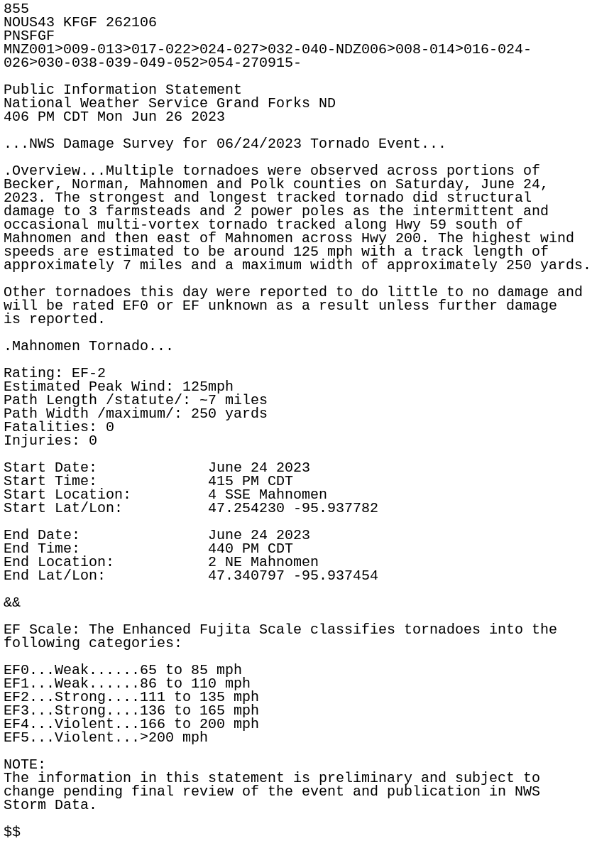
855
NOUS43 KFGF 262106
PNSFGF
MNZ001>009-013>017-022>024-027>032-040-NDZ006>008-014>016-024-
026>030-038-039-049-052>054-270915-

Public Information Statement
National Weather Service Grand Forks ND
406 PM CDT Mon Jun 26 2023

...NWS Damage Survey for 06/24/2023 Tornado Event...

.Overview...Multiple tornadoes were observed across portions of
Becker, Norman, Mahnomen and Polk counties on Saturday, June 24,
2023. The strongest and longest tracked tornado did structural
damage to 3 farmsteads and 2 power poles as the intermittent and
occasional multi-vortex tornado tracked along Hwy 59 south of
Mahnomen and then east of Mahnomen across Hwy 200. The highest wind
speeds are estimated to be around 125 mph with a track length of
approximately 7 miles and a maximum width of approximately 250 yards.

Other tornadoes this day were reported to do little to no damage and
will be rated EF0 or EF unknown as a result unless further damage
is reported.

.Mahnomen Tornado...

Rating: EF-2
Estimated Peak Wind: 125mph
Path Length /statute/: ~7 miles
Path Width /maximum/: 250 yards
Fatalities: 0
Injuries: 0

Start Date:             June 24 2023
Start Time:             415 PM CDT
Start Location:         4 SSE Mahnomen
Start Lat/Lon:          47.254230 -95.937782

End Date:               June 24 2023
End Time:               440 PM CDT
End Location:           2 NE Mahnomen
End Lat/Lon:            47.340797 -95.937454

&&

EF Scale: The Enhanced Fujita Scale classifies tornadoes into the
following categories:

EF0...Weak......65 to 85 mph
EF1...Weak......86 to 110 mph
EF2...Strong....111 to 135 mph
EF3...Strong....136 to 165 mph
EF4...Violent...166 to 200 mph
EF5...Violent...>200 mph

NOTE:
The information in this statement is preliminary and subject to
change pending final review of the event and publication in NWS
Storm Data.

$$