National Weather Service Raw Text Product
Displaying AFOS PIL: PNSCLE Product Timestamp: 2023-06-23 17:42 UTC
Previous in Time Latest Product Next in Time
View All KCLE Products for 23 Jun 2023 View All PNS Products for 23 Jun 2023 View As Image Download As Text
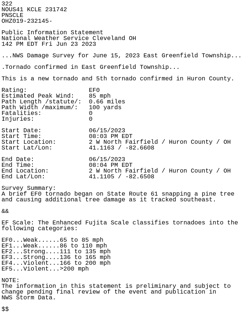
322
NOUS41 KCLE 231742
PNSCLE
OHZ019-232145-

Public Information Statement
National Weather Service Cleveland OH
142 PM EDT Fri Jun 23 2023

...NWS Damage Survey for June 15, 2023 East Greenfield Township...

.Tornado confirmed in East Greenfield Township...

This is a new tornado and 5th tornado confirmed in Huron County.

Rating:                 EF0
Estimated Peak Wind:    85 mph
Path Length /statute/:  0.66 miles
Path Width /maximum/:   100 yards
Fatalities:             0
Injuries:               0

Start Date:             06/15/2023
Start Time:             08:03 PM EDT
Start Location:         2 W North Fairfield / Huron County / OH
Start Lat/Lon:          41.1163 / -82.6608

End Date:               06/15/2023
End Time:               08:04 PM EDT
End Location:           2 W North Fairfield / Huron County / OH
End Lat/Lon:            41.1105 / -82.6508

Survey Summary:
A brief EF0 tornado began on State Route 61 snapping a pine tree
and causing additional tree damage as it tracked southeast.

&&

EF Scale: The Enhanced Fujita Scale classifies tornadoes into the
following categories:

EF0...Weak......65 to 85 mph
EF1...Weak......86 to 110 mph
EF2...Strong....111 to 135 mph
EF3...Strong....136 to 165 mph
EF4...Violent...166 to 200 mph
EF5...Violent...>200 mph

NOTE:
The information in this statement is preliminary and subject to
change pending final review of the event and publication in
NWS Storm Data.

$$