National Weather Service Raw Text Product
Displaying AFOS PIL: LSRLUB Product Timestamp: 2023-06-22 10:21 UTC
Previous in Time Latest Product Next in Time
View All KLUB Products for 22 Jun 2023 View All LSR Products for 22 Jun 2023 View As Image Download As Text
396
NWUS54 KLUB 221021
LSRLUB
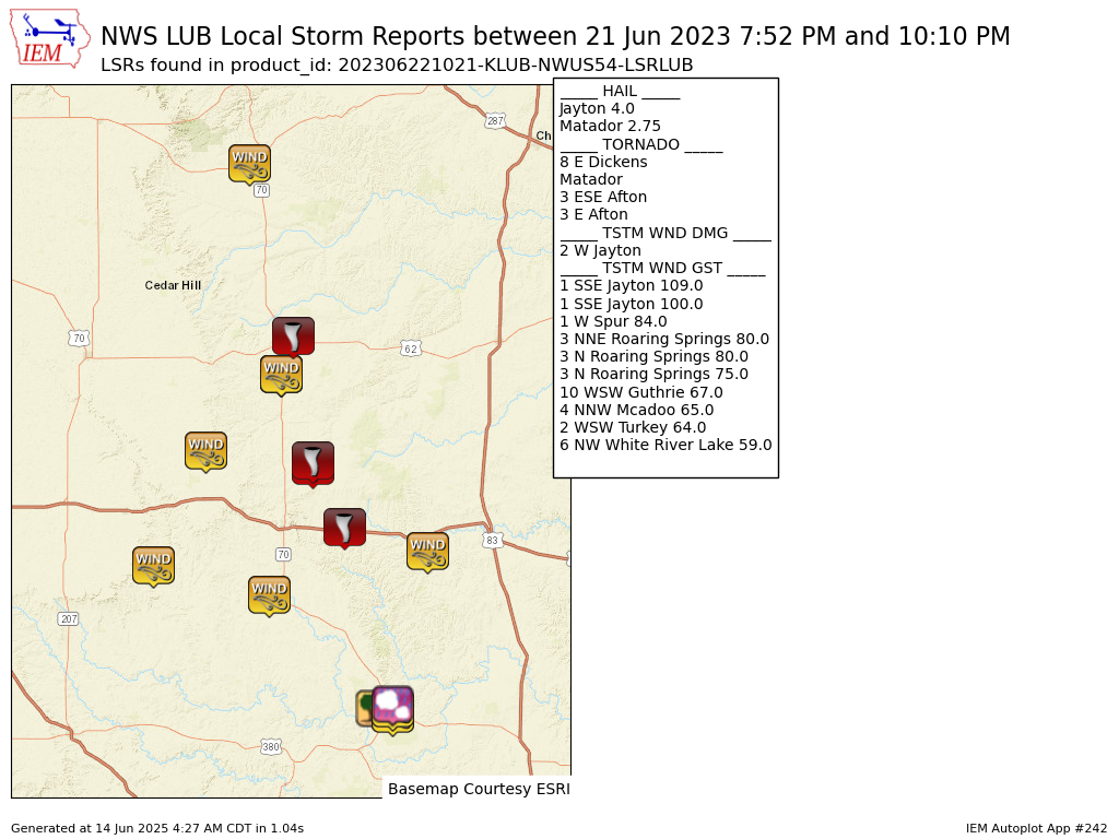
Preliminary Local Storm Report...Summary
National Weather Service Lubbock TX
521 AM CDT Thu Jun 22 2023
..TIME... ...EVENT... ...CITY LOCATION... ...LAT.LON...
..DATE... ....MAG.... ..COUNTY LOCATION..ST.. ...SOURCE....
..REMARKS..
0752 PM Tstm Wnd Gst 2 WSW Turkey 34.38N 100.93W
06/21/2023 M64 MPH Hall TX Mesonet
0811 PM Tornado Matador 34.02N 100.82W
06/21/2023 Motley TX Fire Dept/Rescue
*** 4 FATAL, 9 INJ ***
Significant damage on the west side of
Matador. Several buildings heavily damaged
or destroyed.
0815 PM Hail Matador 34.02N 100.82W
06/21/2023 E2.75 inch Motley TX Emergency Mngr
Baseball size hail reported in Matador.
0822 PM Tstm Wnd Gst 3 N Roaring Springs 33.94N 100.85W
06/21/2023 M75 MPH Motley TX Mesonet
West Texas Mesonet Report.
0833 PM Tornado 3 E Afton 33.76N 100.77W
06/21/2023 Dickens TX NWS Employee
0833 PM Tornado 3 ESE Afton 33.75N 100.77W
06/21/2023 Dickens TX Mesonet
Rain wrapped tornado reported by off-duty
NWS Employee.
0853 PM Tstm Wnd Gst 3 NNE Roaring Springs 33.94N 100.85W
06/21/2023 M80 MPH Motley TX Mesonet
0853 PM Tstm Wnd Gst 3 N Roaring Springs 33.94N 100.85W
06/21/2023 M80 MPH Motley TX Mesonet
West Texas Mesonet Report.
0915 PM Tstm Wnd Gst 4 NNW Mcadoo 33.78N 101.04W
06/21/2023 M65 MPH Dickens TX Mesonet
Mesonet.
0920 PM Tornado 8 E Dickens 33.62N 100.69W
06/21/2023 Dickens TX Law Enforcement
0932 PM Tstm Wnd Gst 1 W Spur 33.48N 100.88W
06/21/2023 M84 MPH Dickens TX Mesonet
0934 PM Tstm Wnd Gst 10 WSW Guthrie 33.57N 100.48W
06/21/2023 M67 MPH King TX Mesonet
0938 PM Tstm Wnd Gst 6 NW White River Lake 33.54N 101.17W
06/21/2023 M59 MPH Crosby TX Mesonet
1000 PM Tstm Wnd Dmg 2 W Jayton 33.24N 100.61W
06/21/2023 Kent TX Law Enforcement
Roofs removed from homes, trees uprooted and
downed power lines reported. Time estimated.
1000 PM Tstm Wnd Gst 1 SSE Jayton 33.24N 100.57W
06/21/2023 M100 MPH Kent TX Mesonet
1007 PM Tstm Wnd Gst 1 SSE Jayton 33.23N 100.57W
06/21/2023 M109 MPH Kent TX Mesonet
Sustained RFD winds as high as 86 mph.
Severe winds from 957 PM to 1018 PM.
Measured by the West Texas Mesonet.
1010 PM Hail Jayton 33.25N 100.57W
06/21/2023 M4.00 inch Kent TX Law Enforcement
&&
$$