National Weather Service Raw Text Product
Displaying AFOS PIL: PNSMOB Product Timestamp: 2023-03-28 03:54 UTC
Previous in Time Latest Product Next in Time
View All KMOB Products for 28 Mar 2023 View All PNS Products for 28 Mar 2023 View As Image Download As Text
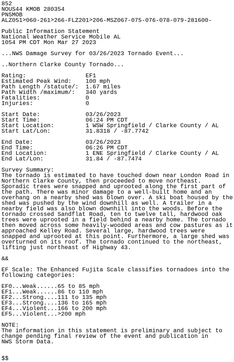
852
NOUS44 KMOB 280354
PNSMOB
ALZ051>060-261>266-FLZ201>206-MSZ067-075-076-078-079-281600-

Public Information Statement
National Weather Service Mobile AL
1054 PM CDT Mon Mar 27 2023

...NWS Damage Survey for 03/26/2023 Tornado Event...

..Northern Clarke County Tornado...

Rating:                 EF1
Estimated Peak Wind:    100 mph
Path Length /statute/:  1.67 miles
Path Width /maximum/:   340 yards
Fatalities:             0
Injuries:               0

Start Date:             03/26/2023
Start Time:             06:24 PM CDT
Start Location:         1 WSW Springfield / Clarke County / AL
Start Lat/Lon:          31.8318 / -87.7742

End Date:               03/26/2023
End Time:               06:26 PM CDT
End Location:           1 ENE Springfield / Clarke County / AL
End Lat/Lon:            31.84 / -87.7474

Survey Summary:
The tornado is estimated to have touched down near London Road in
Northern Clarke County, then proceeded to move northeast.
Sporadic trees were snapped and uprooted along the first part of
the path. There was minor damage to a well-built home and an
overhang on a nearby shed was blown over. A ski boat housed by the
shed was pushed by the wind downhill as well. A trailer in a
nearby field was also blown downhill into the woods. Before the
tornado crossed Sandflat Road, ten to twelve tall, hardwood oak
trees were uprooted in a field behind a nearby home. The tornado
then moved across some heavily-wooded areas and cow pastures as it
approached Kelley Road. Several large, hardwood trees were
snapped and uprooted at this point. Furthermore, a large shed was
overturned on its roof. The tornado continued to the northeast,
lifting just northeast of Highway 43.

&&

EF Scale: The Enhanced Fujita Scale classifies tornadoes into the
following categories:

EF0...Weak......65 to 85 mph
EF1...Weak......86 to 110 mph
EF2...Strong....111 to 135 mph
EF3...Strong....136 to 165 mph
EF4...Violent...166 to 200 mph
EF5...Violent...>200 mph

NOTE:
The information in this statement is preliminary and subject to
change pending final review of the event and publication in
NWS Storm Data.


$$