National Weather Service Raw Text Product
Displaying AFOS PIL: PNSILM Product Timestamp: 2020-12-14 22:39 UTC
Previous in Time Latest Product Next in Time
View All KILM Products for 14 Dec 2020 View All PNS Products for 14 Dec 2020 View As Image Download As Text
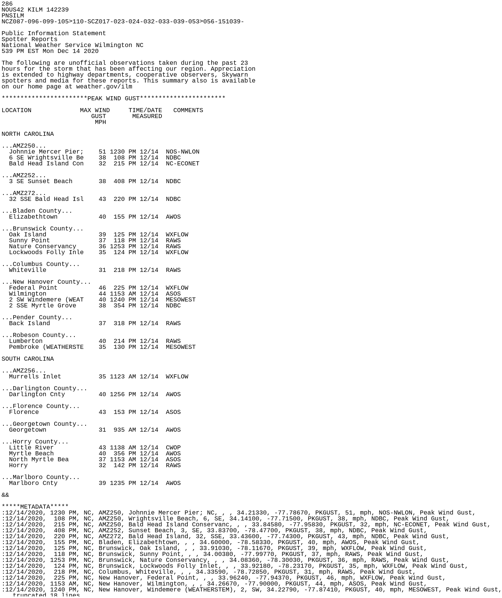
286
NOUS42 KILM 142239
PNSILM
NCZ087-096-099-105>110-SCZ017-023-024-032-033-039-053>056-151039-

Public Information Statement
Spotter Reports
National Weather Service Wilmington NC
539 PM EST Mon Dec 14 2020

The following are unofficial observations taken during the past 23
hours for the storm that has been affecting our region. Appreciation
is extended to highway departments, cooperative observers, Skywarn
spotters and media for these reports. This summary also is available
on our home page at weather.gov/ilm

***********************PEAK WIND GUST***********************

LOCATION             MAX WIND     TIME/DATE   COMMENTS
                        GUST       MEASURED
                         MPH

NORTH CAROLINA

...AMZ250...
  Johnnie Mercer Pier;    51 1230 PM 12/14  NOS-NWLON
  6 SE Wrightsville Be    38  108 PM 12/14  NDBC
  Bald Head Island Con    32  215 PM 12/14  NC-ECONET

...AMZ252...
  3 SE Sunset Beach       38  408 PM 12/14  NDBC

...AMZ272...
  32 SSE Bald Head Isl    43  220 PM 12/14  NDBC

...Bladen County...
  Elizabethtown           40  155 PM 12/14  AWOS

...Brunswick County...
  Oak Island              39  125 PM 12/14  WXFLOW
  Sunny Point             37  118 PM 12/14  RAWS
  Nature Conservancy      36 1253 PM 12/14  RAWS
  Lockwoods Folly Inle    35  124 PM 12/14  WXFLOW

...Columbus County...
  Whiteville              31  218 PM 12/14  RAWS

...New Hanover County...
  Federal Point           46  225 PM 12/14  WXFLOW
  Wilmington              44 1153 AM 12/14  ASOS
  2 SW Windemere (WEAT    40 1240 PM 12/14  MESOWEST
  2 SSE Myrtle Grove      38  354 PM 12/14  NDBC

...Pender County...
  Back Island             37  318 PM 12/14  RAWS

...Robeson County...
  Lumberton               40  214 PM 12/14  RAWS
  Pembroke (WEATHERSTE    35  130 PM 12/14  MESOWEST

SOUTH CAROLINA

...AMZ256...
  Murrells Inlet          35 1123 AM 12/14  WXFLOW

...Darlington County...
  Darlington Cnty         40 1256 PM 12/14  AWOS

...Florence County...
  Florence                43  153 PM 12/14  ASOS

...Georgetown County...
  Georgetown              31  935 AM 12/14  AWOS

...Horry County...
  Little River            43 1138 AM 12/14  CWOP
  Myrtle Beach            40  356 PM 12/14  AWOS
  North Myrtle Bea        37 1153 AM 12/14  ASOS
  Horry                   32  142 PM 12/14  RAWS

...Marlboro County...
  Marlboro Cnty           39 1235 PM 12/14  AWOS

&&

*****METADATA*****
:12/14/2020, 1230 PM, NC, AMZ250, Johnnie Mercer Pier; NC, , , 34.21330, -77.78670, PKGUST, 51, mph, NOS-NWLON, Peak Wind Gust,
:12/14/2020,  108 PM, NC, AMZ250, Wrightsville Beach, 6, SE, 34.14100, -77.71500, PKGUST, 38, mph, NDBC, Peak Wind Gust,
:12/14/2020,  215 PM, NC, AMZ250, Bald Head Island Conservanc, , , 33.84580, -77.95830, PKGUST, 32, mph, NC-ECONET, Peak Wind Gust,
:12/14/2020,  408 PM, NC, AMZ252, Sunset Beach, 3, SE, 33.83700, -78.47700, PKGUST, 38, mph, NDBC, Peak Wind Gust,
:12/14/2020,  220 PM, NC, AMZ272, Bald Head Island, 32, SSE, 33.43600, -77.74300, PKGUST, 43, mph, NDBC, Peak Wind Gust,
:12/14/2020,  155 PM, NC, Bladen, Elizabethtown, , , 34.60000, -78.58330, PKGUST, 40, mph, AWOS, Peak Wind Gust,
:12/14/2020,  125 PM, NC, Brunswick, Oak Island, , , 33.91030, -78.11670, PKGUST, 39, mph, WXFLOW, Peak Wind Gust,
:12/14/2020,  118 PM, NC, Brunswick, Sunny Point, , , 34.00380, -77.99770, PKGUST, 37, mph, RAWS, Peak Wind Gust,
:12/14/2020, 1253 PM, NC, Brunswick, Nature Conservancy, , , 34.08360, -78.30030, PKGUST, 36, mph, RAWS, Peak Wind Gust,
:12/14/2020,  124 PM, NC, Brunswick, Lockwoods Folly Inlet, , , 33.92180, -78.23170, PKGUST, 35, mph, WXFLOW, Peak Wind Gust,
:12/14/2020,  218 PM, NC, Columbus, Whiteville, , , 34.33590, -78.72850, PKGUST, 31, mph, RAWS, Peak Wind Gust,
:12/14/2020,  225 PM, NC, New Hanover, Federal Point, , , 33.96240, -77.94370, PKGUST, 46, mph, WXFLOW, Peak Wind Gust,
:12/14/2020, 1153 AM, NC, New Hanover, Wilmington, , , 34.26670, -77.90000, PKGUST, 44, mph, ASOS, Peak Wind Gust,
:12/14/2020, 1240 PM, NC, New Hanover, Windemere (WEATHERSTEM), 2, SW, 34.22790, -77.87410, PKGUST, 40, mph, MESOWEST, Peak Wind Gust,
:12/14/2020,  354 PM, NC, New Hanover, Myrtle Grove, 2, SSE, 34.09100, -77.86800, PKGUST, 38, mph, NDBC, Peak Wind Gust,
:12/14/2020,  318 PM, NC, Pender, Back Island, , , 34.53280, -77.72200, PKGUST, 37, mph, RAWS, Peak Wind Gust,
:12/14/2020,  214 PM, NC, Robeson, Lumberton, , , 34.59510, -79.08490, PKGUST, 40, mph, RAWS, Peak Wind Gust,
:12/14/2020,  130 PM, NC, Robeson, Pembroke (WEATHERSTEM), , , 34.68670, -79.20230, PKGUST, 35, mph, MESOWEST, Peak Wind Gust,
:12/14/2020, 1123 AM, SC, AMZ256, Murrells Inlet, , , 33.52430, -79.02590, PKGUST, 35, mph, WXFLOW, Peak Wind Gust,
:12/14/2020, 1256 PM, SC, Darlington, Darlington Cnty, , , 34.45000, -79.88330, PKGUST, 40, mph, AWOS, Peak Wind Gust,
:12/14/2020,  153 PM, SC, Florence, Florence, , , 34.18330, -79.73330, PKGUST, 43, mph, ASOS, Peak Wind Gust,
:12/14/2020,  935 AM, SC, Georgetown, Georgetown, , , 33.31670, -79.31670, PKGUST, 31, mph, AWOS, Peak Wind Gust,
:12/14/2020, 1138 AM, SC, Horry, Little River, , , 33.88330, -78.63220, PKGUST, 43, mph, CWOP, Peak Wind Gust,
:12/14/2020,  356 PM, SC, Horry, Myrtle Beach, , , 33.66670, -78.91670, PKGUST, 40, mph, AWOS, Peak Wind Gust,
:12/14/2020, 1153 AM, SC, Horry, North Myrtle Bea, , , 33.81670, -78.71670, PKGUST, 37, mph, ASOS, Peak Wind Gust,
:12/14/2020,  142 PM, SC, Horry, Horry, , , 33.93680, -79.08490, PKGUST, 32, mph, RAWS, Peak Wind Gust,
:12/14/2020, 1235 PM, SC, Marlboro, Marlboro Cnty, , , 34.61670, -79.73330, PKGUST, 39, mph, AWOS, Peak Wind Gust,

$$

shk