National Weather Service Raw Text Product
Displaying AFOS PIL: PNSMPX Product Timestamp: 2020-07-13 02:49 UTC
Previous in Time Latest Product Next in Time
View All KMPX Products for 13 Jul 2020 View All PNS Products for 13 Jul 2020 View As Image Download As Text
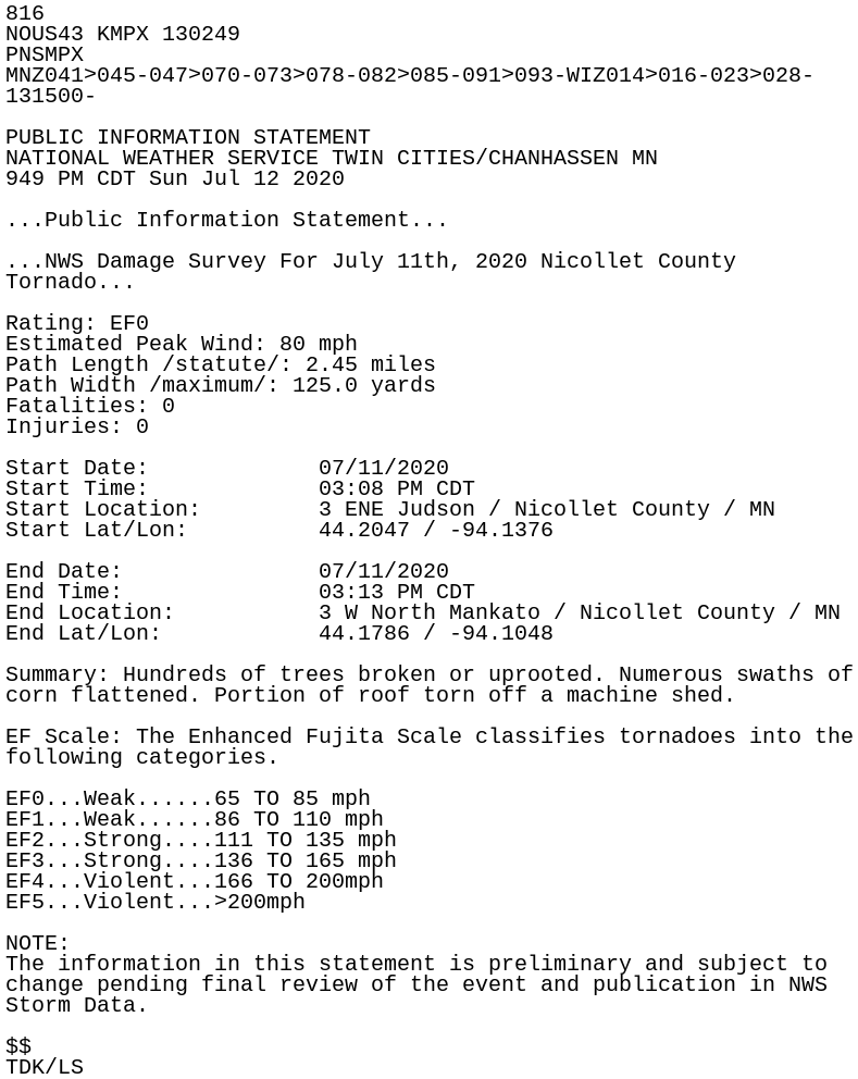
816
NOUS43 KMPX 130249
PNSMPX
MNZ041>045-047>070-073>078-082>085-091>093-WIZ014>016-023>028-
131500-

PUBLIC INFORMATION STATEMENT
NATIONAL WEATHER SERVICE TWIN CITIES/CHANHASSEN MN
949 PM CDT Sun Jul 12 2020

...Public Information Statement...

...NWS Damage Survey For July 11th, 2020 Nicollet County
Tornado...

Rating: EF0
Estimated Peak Wind: 80 mph
Path Length /statute/: 2.45 miles
Path Width /maximum/: 125.0 yards
Fatalities: 0
Injuries: 0

Start Date:             07/11/2020
Start Time:             03:08 PM CDT
Start Location:         3 ENE Judson / Nicollet County / MN
Start Lat/Lon:          44.2047 / -94.1376

End Date:               07/11/2020
End Time:               03:13 PM CDT
End Location:           3 W North Mankato / Nicollet County / MN
End Lat/Lon:            44.1786 / -94.1048

Summary: Hundreds of trees broken or uprooted. Numerous swaths of
corn flattened. Portion of roof torn off a machine shed.

EF Scale: The Enhanced Fujita Scale classifies tornadoes into the
following categories.

EF0...Weak......65 TO 85 mph
EF1...Weak......86 TO 110 mph
EF2...Strong....111 TO 135 mph
EF3...Strong....136 TO 165 mph
EF4...Violent...166 TO 200mph
EF5...Violent...>200mph

NOTE:
The information in this statement is preliminary and subject to
change pending final review of the event and publication in NWS
Storm Data.

$$
TDK/LS