National Weather Service Raw Text Product
Displaying AFOS PIL: PNSUNR Product Timestamp: 2020-07-08 19:37 UTC
Previous in Time Latest Product Next in Time
View All KUNR Products for 08 Jul 2020 View All PNS Products for 08 Jul 2020 View As Image Download As Text
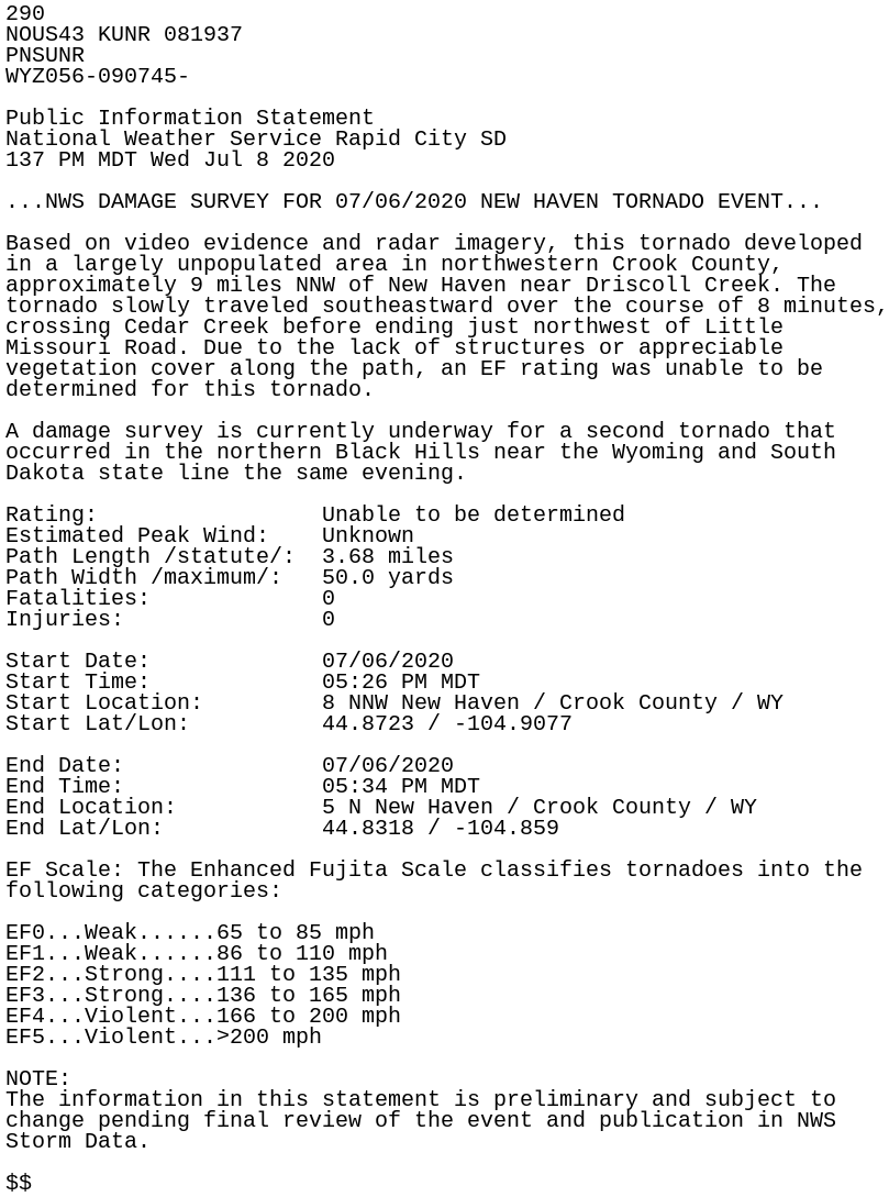
290
NOUS43 KUNR 081937
PNSUNR
WYZ056-090745-

Public Information Statement
National Weather Service Rapid City SD
137 PM MDT Wed Jul 8 2020

...NWS DAMAGE SURVEY FOR 07/06/2020 NEW HAVEN TORNADO EVENT...

Based on video evidence and radar imagery, this tornado developed
in a largely unpopulated area in northwestern Crook County,
approximately 9 miles NNW of New Haven near Driscoll Creek. The
tornado slowly traveled southeastward over the course of 8 minutes,
crossing Cedar Creek before ending just northwest of Little
Missouri Road. Due to the lack of structures or appreciable
vegetation cover along the path, an EF rating was unable to be
determined for this tornado.

A damage survey is currently underway for a second tornado that
occurred in the northern Black Hills near the Wyoming and South
Dakota state line the same evening.

Rating:                 Unable to be determined
Estimated Peak Wind:    Unknown
Path Length /statute/:  3.68 miles
Path Width /maximum/:   50.0 yards
Fatalities:             0
Injuries:               0

Start Date:             07/06/2020
Start Time:             05:26 PM MDT
Start Location:         8 NNW New Haven / Crook County / WY
Start Lat/Lon:          44.8723 / -104.9077

End Date:               07/06/2020
End Time:               05:34 PM MDT
End Location:           5 N New Haven / Crook County / WY
End Lat/Lon:            44.8318 / -104.859

EF Scale: The Enhanced Fujita Scale classifies tornadoes into the
following categories:

EF0...Weak......65 to 85 mph
EF1...Weak......86 to 110 mph
EF2...Strong....111 to 135 mph
EF3...Strong....136 to 165 mph
EF4...Violent...166 to 200 mph
EF5...Violent...>200 mph

NOTE:
The information in this statement is preliminary and subject to
change pending final review of the event and publication in NWS
Storm Data.

$$