National Weather Service Raw Text Product
Displaying AFOS PIL: PNSGSP Product Timestamp: 2020-05-23 19:46 UTC
Previous in Time Latest Product Next in Time
View All KGSP Products for 23 May 2020 View All PNS Products for 23 May 2020 View As Image Download As Text
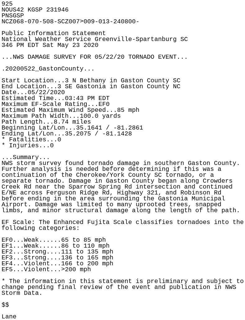
925
NOUS42 KGSP 231946
PNSGSP
NCZ068-070-508-SCZ007>009-013-240800-

Public Information Statement
National Weather Service Greenville-Spartanburg SC
346 PM EDT Sat May 23 2020

...NWS DAMAGE SURVEY FOR 05/22/20 TORNADO EVENT...

.20200522_GastonCounty...

Start Location...3 N Bethany in Gaston County SC
End Location...3 SE Gastonia in Gaston County NC
Date...05/22/2020
Estimated Time...03:43 PM EDT
Maximum EF-Scale Rating...EF0
Estimated Maximum Wind Speed...85 mph
Maximum Path Width...100.0 yards
Path Length...8.74 miles
Beginning Lat/Lon...35.1641 / -81.2861
Ending Lat/Lon...35.2075 / -81.1428
* Fatalities...0
* Injuries...0

...Summary...
NWS storm survey found tornado damage in southern Gaston County.
Further analysis is needed before determining if this was a
continuation of the Cherokee/York County SC tornado, or a
separate tornado. Damage in Gaston County began along Crowders
Creek Rd near the Sparrow Spring Rd intersection and continued
E/NE across Ferguson Ridge Rd, Highway 321, and Robinson Rd
before ending in the area surrounding the Gastonia Municipal
Airport. Damage was limited to many uprooted trees, snapped
limbs, and minor structural damage along the length of the path.

EF Scale: The Enhanced Fujita Scale classifies tornadoes into the
following categories:

EF0...Weak......65 to 85 mph
EF1...Weak......86 to 110 mph
EF2...Strong....111 to 135 mph
EF3...Strong....136 to 165 mph
EF4...Violent...166 to 200 mph
EF5...Violent...>200 mph

* The information in this statement is preliminary and subject to
change pending final review of the event and publication in NWS
Storm Data.

$$

Lane