National Weather Service Raw Text Product
Displaying AFOS PIL: TORFFC Product Timestamp: 2020-04-13 01:53 UTC
Previous in Time Latest Product Next in Time
View All KFFC Products for 13 Apr 2020 View All TOR Products for 13 Apr 2020 View As Image Download As Text
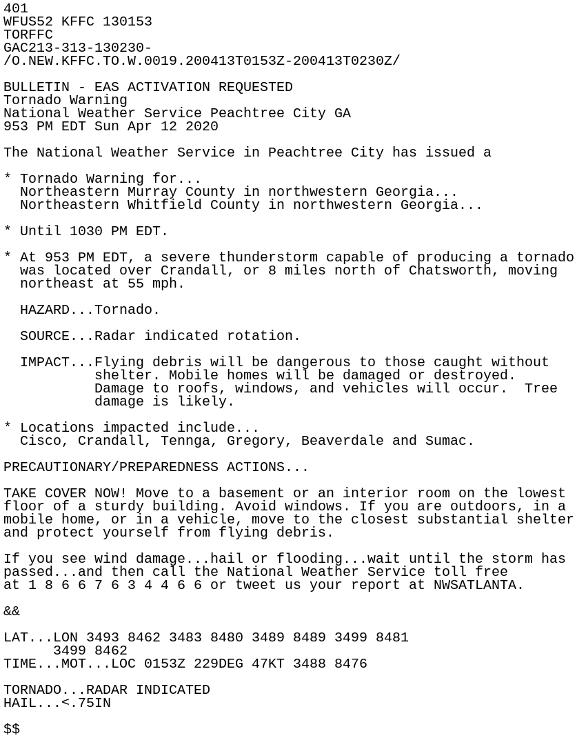
401
WFUS52 KFFC 130153
TORFFC
GAC213-313-130230-
/O.NEW.KFFC.TO.W.0019.200413T0153Z-200413T0230Z/

BULLETIN - EAS ACTIVATION REQUESTED
Tornado Warning
National Weather Service Peachtree City GA
953 PM EDT Sun Apr 12 2020

The National Weather Service in Peachtree City has issued a

* Tornado Warning for...
  Northeastern Murray County in northwestern Georgia...
  Northeastern Whitfield County in northwestern Georgia...

* Until 1030 PM EDT.

* At 953 PM EDT, a severe thunderstorm capable of producing a tornado
  was located over Crandall, or 8 miles north of Chatsworth, moving
  northeast at 55 mph.

  HAZARD...Tornado.

  SOURCE...Radar indicated rotation.

  IMPACT...Flying debris will be dangerous to those caught without
           shelter. Mobile homes will be damaged or destroyed.
           Damage to roofs, windows, and vehicles will occur.  Tree
           damage is likely.

* Locations impacted include...
  Cisco, Crandall, Tennga, Gregory, Beaverdale and Sumac.

PRECAUTIONARY/PREPAREDNESS ACTIONS...

TAKE COVER NOW! Move to a basement or an interior room on the lowest
floor of a sturdy building. Avoid windows. If you are outdoors, in a
mobile home, or in a vehicle, move to the closest substantial shelter
and protect yourself from flying debris.

If you see wind damage...hail or flooding...wait until the storm has
passed...and then call the National Weather Service toll free
at 1 8 6 6 7 6 3 4 4 6 6 or tweet us your report at NWSATLANTA.

&&

LAT...LON 3493 8462 3483 8480 3489 8489 3499 8481
      3499 8462
TIME...MOT...LOC 0153Z 229DEG 47KT 3488 8476

TORNADO...RADAR INDICATED
HAIL...<.75IN

$$