National Weather Service Raw Text Product
Displaying AFOS PIL: PNSGSP Product Timestamp: 2020-02-07 20:34 UTC
Previous in Time Latest Product Next in Time
View All KGSP Products for 07 Feb 2020 View All PNS Products for 07 Feb 2020 View As Image Download As Text
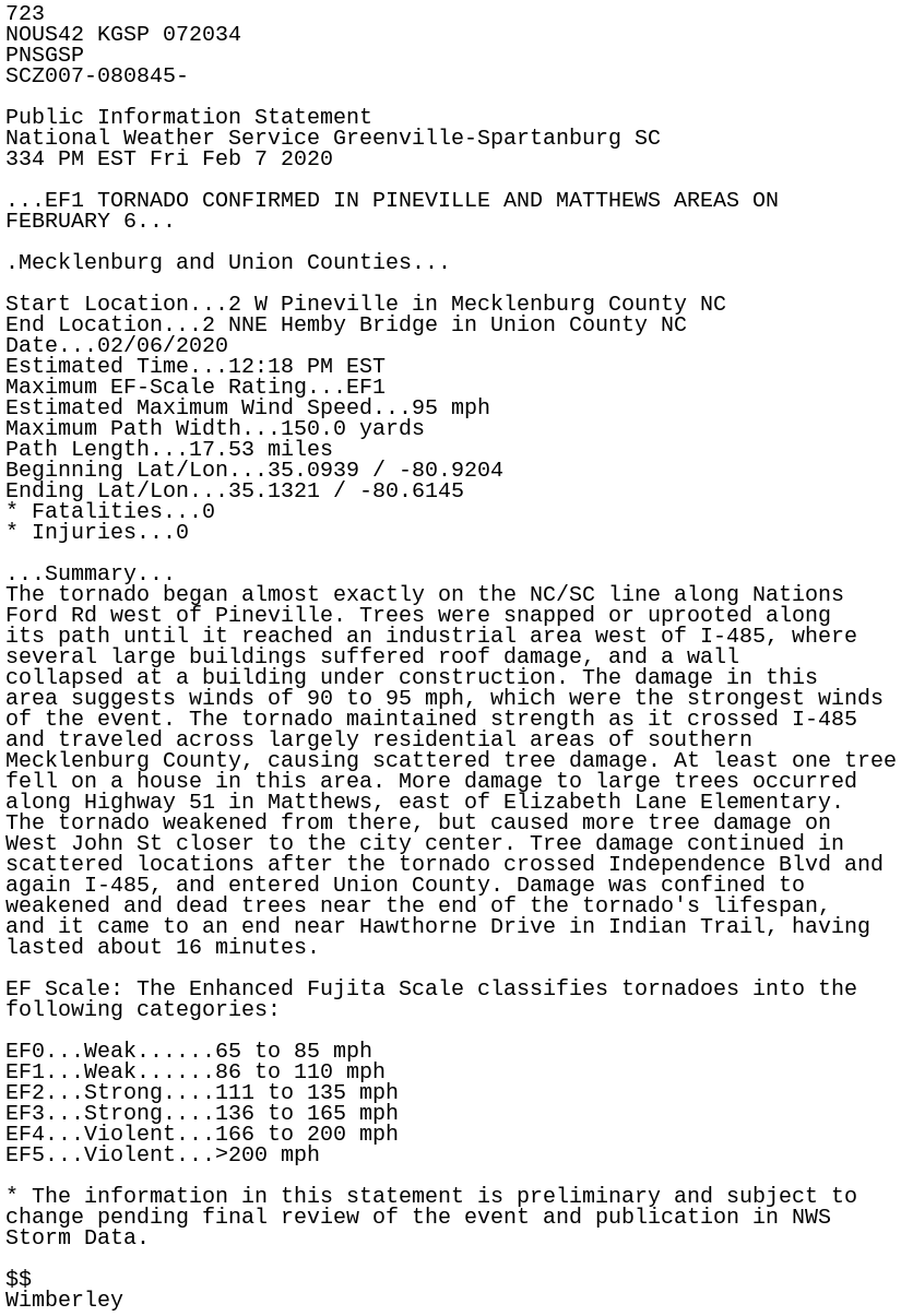
723
NOUS42 KGSP 072034
PNSGSP
SCZ007-080845-

Public Information Statement
National Weather Service Greenville-Spartanburg SC
334 PM EST Fri Feb 7 2020

...EF1 TORNADO CONFIRMED IN PINEVILLE AND MATTHEWS AREAS ON
FEBRUARY 6...

.Mecklenburg and Union Counties...

Start Location...2 W Pineville in Mecklenburg County NC
End Location...2 NNE Hemby Bridge in Union County NC
Date...02/06/2020
Estimated Time...12:18 PM EST
Maximum EF-Scale Rating...EF1
Estimated Maximum Wind Speed...95 mph
Maximum Path Width...150.0 yards
Path Length...17.53 miles
Beginning Lat/Lon...35.0939 / -80.9204
Ending Lat/Lon...35.1321 / -80.6145
* Fatalities...0
* Injuries...0

...Summary...
The tornado began almost exactly on the NC/SC line along Nations
Ford Rd west of Pineville. Trees were snapped or uprooted along
its path until it reached an industrial area west of I-485, where
several large buildings suffered roof damage, and a wall
collapsed at a building under construction. The damage in this
area suggests winds of 90 to 95 mph, which were the strongest winds
of the event. The tornado maintained strength as it crossed I-485
and traveled across largely residential areas of southern
Mecklenburg County, causing scattered tree damage. At least one tree
fell on a house in this area. More damage to large trees occurred
along Highway 51 in Matthews, east of Elizabeth Lane Elementary.
The tornado weakened from there, but caused more tree damage on
West John St closer to the city center. Tree damage continued in
scattered locations after the tornado crossed Independence Blvd and
again I-485, and entered Union County. Damage was confined to
weakened and dead trees near the end of the tornado's lifespan,
and it came to an end near Hawthorne Drive in Indian Trail, having
lasted about 16 minutes.

EF Scale: The Enhanced Fujita Scale classifies tornadoes into the
following categories:

EF0...Weak......65 to 85 mph
EF1...Weak......86 to 110 mph
EF2...Strong....111 to 135 mph
EF3...Strong....136 to 165 mph
EF4...Violent...166 to 200 mph
EF5...Violent...>200 mph

* The information in this statement is preliminary and subject to
change pending final review of the event and publication in NWS
Storm Data.

$$
Wimberley