National Weather Service Raw Text Product
Displaying AFOS PIL: PNSGSP Product Timestamp: 2020-02-07 19:31 UTC
Previous in Time Latest Product Next in Time
View All KGSP Products for 07 Feb 2020 View All PNS Products for 07 Feb 2020 View As Image Download As Text
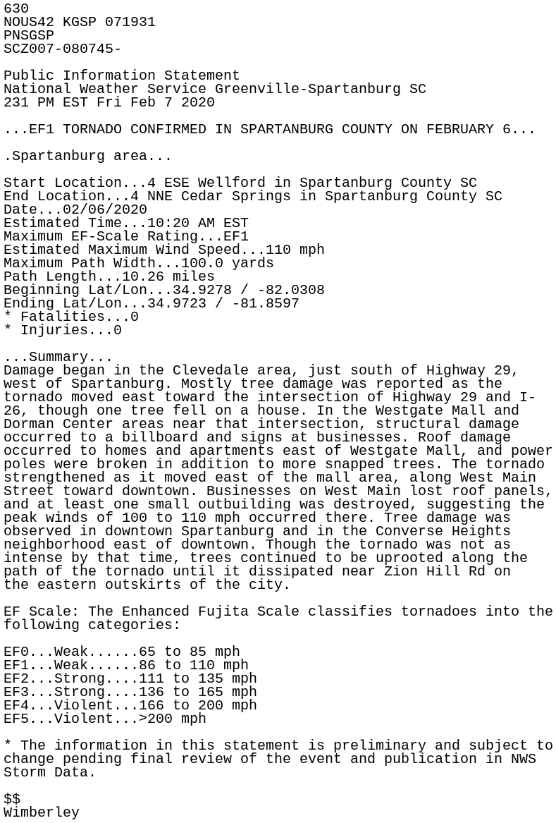
630
NOUS42 KGSP 071931
PNSGSP
SCZ007-080745-

Public Information Statement
National Weather Service Greenville-Spartanburg SC
231 PM EST Fri Feb 7 2020

...EF1 TORNADO CONFIRMED IN SPARTANBURG COUNTY ON FEBRUARY 6...

.Spartanburg area...

Start Location...4 ESE Wellford in Spartanburg County SC
End Location...4 NNE Cedar Springs in Spartanburg County SC
Date...02/06/2020
Estimated Time...10:20 AM EST
Maximum EF-Scale Rating...EF1
Estimated Maximum Wind Speed...110 mph
Maximum Path Width...100.0 yards
Path Length...10.26 miles
Beginning Lat/Lon...34.9278 / -82.0308
Ending Lat/Lon...34.9723 / -81.8597
* Fatalities...0
* Injuries...0

...Summary...
Damage began in the Clevedale area, just south of Highway 29,
west of Spartanburg. Mostly tree damage was reported as the
tornado moved east toward the intersection of Highway 29 and I-
26, though one tree fell on a house. In the Westgate Mall and
Dorman Center areas near that intersection, structural damage
occurred to a billboard and signs at businesses. Roof damage
occurred to homes and apartments east of Westgate Mall, and power
poles were broken in addition to more snapped trees. The tornado
strengthened as it moved east of the mall area, along West Main
Street toward downtown. Businesses on West Main lost roof panels,
and at least one small outbuilding was destroyed, suggesting the
peak winds of 100 to 110 mph occurred there. Tree damage was
observed in downtown Spartanburg and in the Converse Heights
neighborhood east of downtown. Though the tornado was not as
intense by that time, trees continued to be uprooted along the
path of the tornado until it dissipated near Zion Hill Rd on
the eastern outskirts of the city.

EF Scale: The Enhanced Fujita Scale classifies tornadoes into the
following categories:

EF0...Weak......65 to 85 mph
EF1...Weak......86 to 110 mph
EF2...Strong....111 to 135 mph
EF3...Strong....136 to 165 mph
EF4...Violent...166 to 200 mph
EF5...Violent...>200 mph

* The information in this statement is preliminary and subject to
change pending final review of the event and publication in NWS
Storm Data.

$$
Wimberley