National Weather Service Raw Text Product
Displaying AFOS PIL: SVRLWX Product Timestamp: 2019-08-14 00:58 UTC
Previous in Time Latest Product Next in Time
View All KLWX Products for 14 Aug 2019 View All SVR Products for 14 Aug 2019 View As Image Download As Text
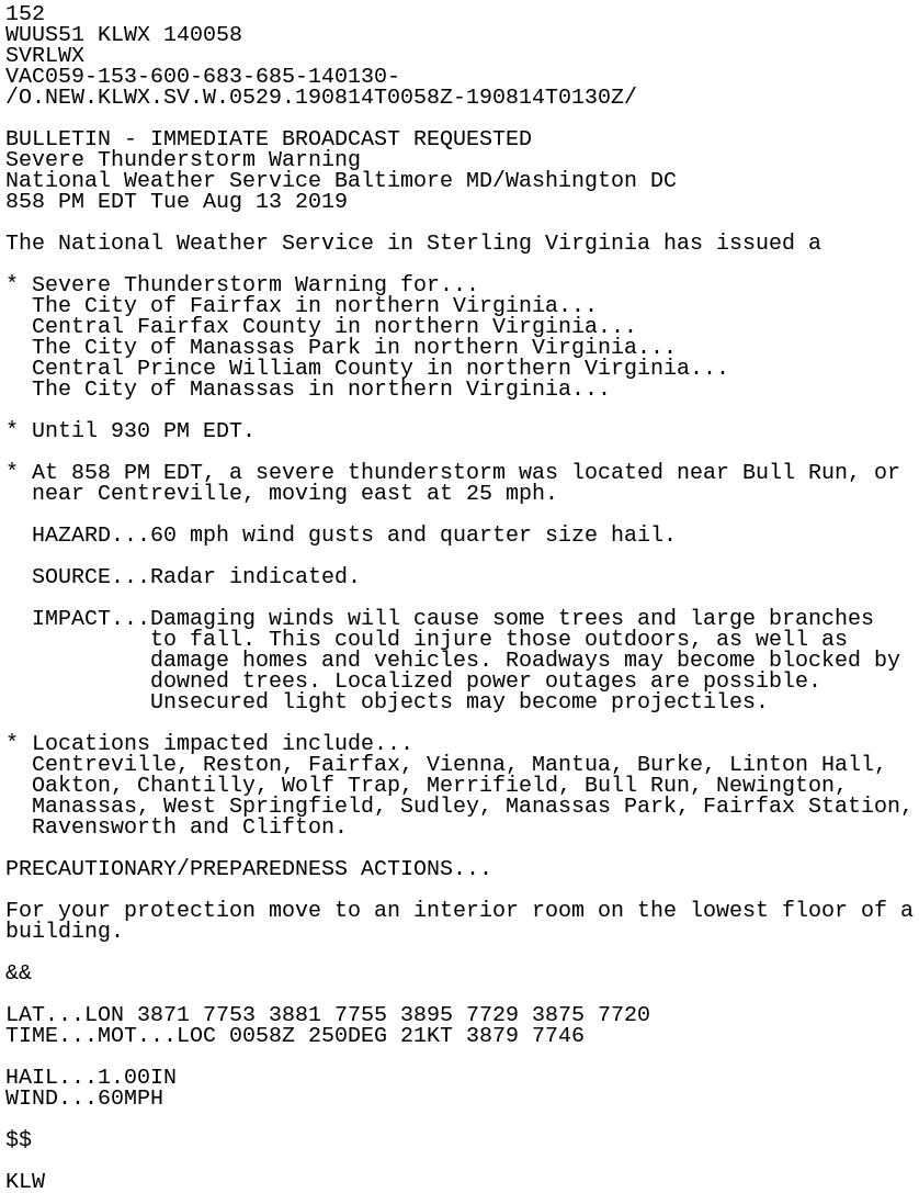
152
WUUS51 KLWX 140058
SVRLWX
VAC059-153-600-683-685-140130-
/O.NEW.KLWX.SV.W.0529.190814T0058Z-190814T0130Z/

BULLETIN - IMMEDIATE BROADCAST REQUESTED
Severe Thunderstorm Warning
National Weather Service Baltimore MD/Washington DC
858 PM EDT Tue Aug 13 2019

The National Weather Service in Sterling Virginia has issued a

* Severe Thunderstorm Warning for...
  The City of Fairfax in northern Virginia...
  Central Fairfax County in northern Virginia...
  The City of Manassas Park in northern Virginia...
  Central Prince William County in northern Virginia...
  The City of Manassas in northern Virginia...

* Until 930 PM EDT.

* At 858 PM EDT, a severe thunderstorm was located near Bull Run, or
  near Centreville, moving east at 25 mph.

  HAZARD...60 mph wind gusts and quarter size hail.

  SOURCE...Radar indicated.

  IMPACT...Damaging winds will cause some trees and large branches
           to fall. This could injure those outdoors, as well as
           damage homes and vehicles. Roadways may become blocked by
           downed trees. Localized power outages are possible.
           Unsecured light objects may become projectiles.

* Locations impacted include...
  Centreville, Reston, Fairfax, Vienna, Mantua, Burke, Linton Hall,
  Oakton, Chantilly, Wolf Trap, Merrifield, Bull Run, Newington,
  Manassas, West Springfield, Sudley, Manassas Park, Fairfax Station,
  Ravensworth and Clifton.

PRECAUTIONARY/PREPAREDNESS ACTIONS...

For your protection move to an interior room on the lowest floor of a
building.

&&

LAT...LON 3871 7753 3881 7755 3895 7729 3875 7720
TIME...MOT...LOC 0058Z 250DEG 21KT 3879 7746

HAIL...1.00IN
WIND...60MPH

$$

KLW