National Weather Service Raw Text Product
Displaying AFOS PIL: PNSUNR Product Timestamp: 2019-06-19 22:04 UTC
Previous in Time Latest Product Next in Time
View All KUNR Products for 19 Jun 2019 View All PNS Products for 19 Jun 2019 View As Image Download As Text
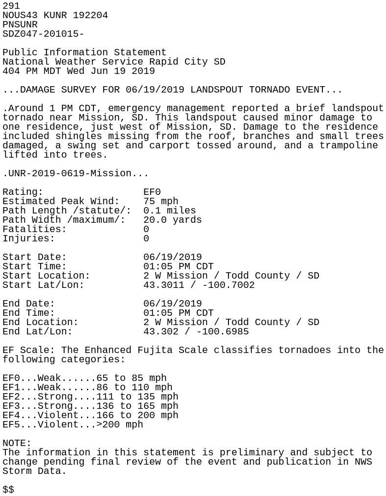
291
NOUS43 KUNR 192204
PNSUNR
SDZ047-201015-

Public Information Statement
National Weather Service Rapid City SD
404 PM MDT Wed Jun 19 2019

...DAMAGE SURVEY FOR 06/19/2019 LANDSPOUT TORNADO EVENT...

.Around 1 PM CDT, emergency management reported a brief landspout
tornado near Mission, SD. This landspout caused minor damage to
one residence, just west of Mission, SD. Damage to the residence
included shingles missing from the roof, branches and small trees
damaged, a swing set and carport tossed around, and a trampoline
lifted into trees.

.UNR-2019-0619-Mission...

Rating:                 EF0
Estimated Peak Wind:    75 mph
Path Length /statute/:  0.1 miles
Path Width /maximum/:   20.0 yards
Fatalities:             0
Injuries:               0

Start Date:             06/19/2019
Start Time:             01:05 PM CDT
Start Location:         2 W Mission / Todd County / SD
Start Lat/Lon:          43.3011 / -100.7002

End Date:               06/19/2019
End Time:               01:05 PM CDT
End Location:           2 W Mission / Todd County / SD
End Lat/Lon:            43.302 / -100.6985

EF Scale: The Enhanced Fujita Scale classifies tornadoes into the
following categories:

EF0...Weak......65 to 85 mph
EF1...Weak......86 to 110 mph
EF2...Strong....111 to 135 mph
EF3...Strong....136 to 165 mph
EF4...Violent...166 to 200 mph
EF5...Violent...>200 mph

NOTE:
The information in this statement is preliminary and subject to
change pending final review of the event and publication in NWS
Storm Data.

$$