National Weather Service Raw Text Product
Displaying AFOS PIL: PNSSGF Product Timestamp: 2019-05-25 00:18 UTC
Previous in Time Latest Product Next in Time
View All KSGF Products for 25 May 2019 View All PNS Products for 25 May 2019 View As Image Download As Text
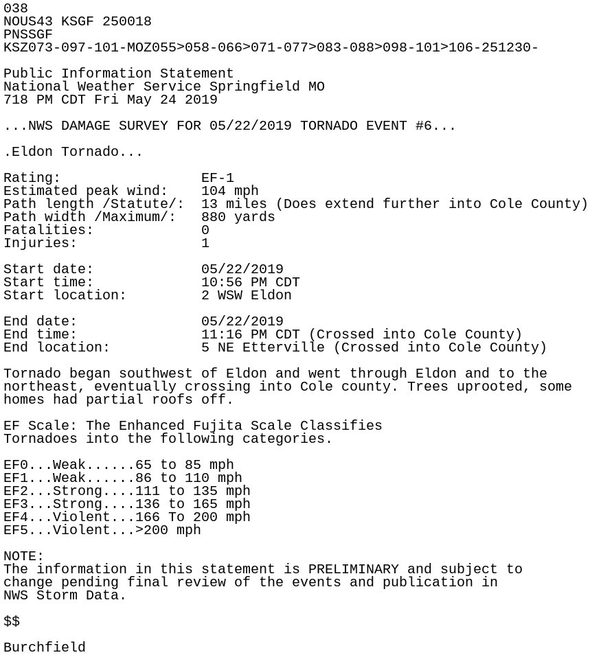
038
NOUS43 KSGF 250018
PNSSGF
KSZ073-097-101-MOZ055>058-066>071-077>083-088>098-101>106-251230-

Public Information Statement
National Weather Service Springfield MO
718 PM CDT Fri May 24 2019

...NWS DAMAGE SURVEY FOR 05/22/2019 TORNADO EVENT #6...

.Eldon Tornado...

Rating:                 EF-1
Estimated peak wind:    104 mph
Path length /Statute/:  13 miles (Does extend further into Cole County)
Path width /Maximum/:   880 yards
Fatalities:             0
Injuries:               1

Start date:             05/22/2019
Start time:             10:56 PM CDT
Start location:         2 WSW Eldon

End date:               05/22/2019
End time:               11:16 PM CDT (Crossed into Cole County)
End location:           5 NE Etterville (Crossed into Cole County)

Tornado began southwest of Eldon and went through Eldon and to the
northeast, eventually crossing into Cole county. Trees uprooted, some
homes had partial roofs off.

EF Scale: The Enhanced Fujita Scale Classifies
Tornadoes into the following categories.

EF0...Weak......65 to 85 mph
EF1...Weak......86 to 110 mph
EF2...Strong....111 to 135 mph
EF3...Strong....136 to 165 mph
EF4...Violent...166 To 200 mph
EF5...Violent...>200 mph

NOTE:
The information in this statement is PRELIMINARY and subject to
change pending final review of the events and publication in
NWS Storm Data.

$$

Burchfield