National Weather Service Raw Text Product
Displaying AFOS PIL: PNSBGM Product Timestamp: 2019-04-16 19:32 UTC
Previous in Time Latest Product Next in Time
View All KBGM Products for 16 Apr 2019 View All PNS Products for 16 Apr 2019 View As Image Download As Text
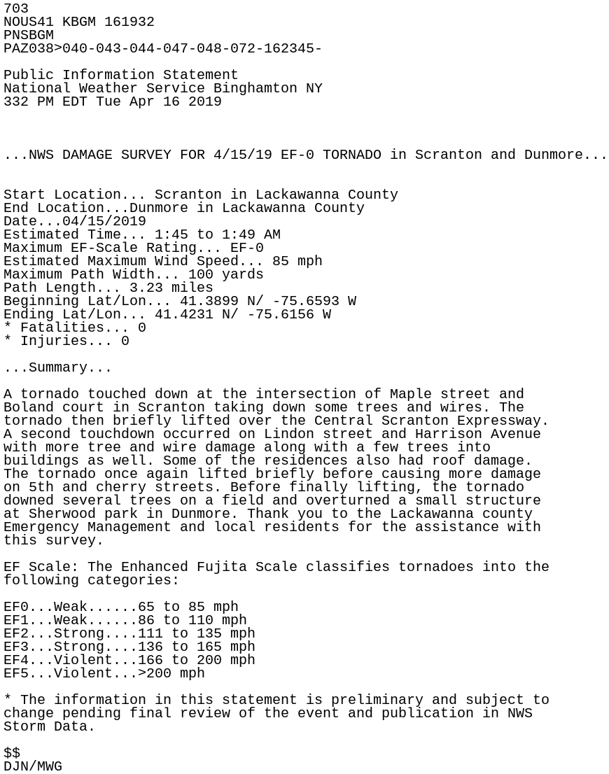
703
NOUS41 KBGM 161932
PNSBGM
PAZ038>040-043-044-047-048-072-162345-

Public Information Statement
National Weather Service Binghamton NY
332 PM EDT Tue Apr 16 2019


...NWS DAMAGE SURVEY FOR 4/15/19 EF-0 TORNADO in Scranton and Dunmore...


Start Location... Scranton in Lackawanna County
End Location...Dunmore in Lackawanna County
Date...04/15/2019
Estimated Time... 1:45 to 1:49 AM
Maximum EF-Scale Rating... EF-0
Estimated Maximum Wind Speed... 85 mph
Maximum Path Width... 100 yards
Path Length... 3.23 miles
Beginning Lat/Lon... 41.3899 N/ -75.6593 W
Ending Lat/Lon... 41.4231 N/ -75.6156 W
* Fatalities... 0
* Injuries... 0

...Summary...

A tornado touched down at the intersection of Maple street and
Boland court in Scranton taking down some trees and wires. The
tornado then briefly lifted over the Central Scranton Expressway.
A second touchdown occurred on Lindon street and Harrison Avenue
with more tree and wire damage along with a few trees into
buildings as well. Some of the residences also had roof damage.
The tornado once again lifted briefly before causing more damage
on 5th and cherry streets. Before finally lifting, the tornado
downed several trees on a field and overturned a small structure
at Sherwood park in Dunmore. Thank you to the Lackawanna county
Emergency Management and local residents for the assistance with
this survey.

EF Scale: The Enhanced Fujita Scale classifies tornadoes into the
following categories:

EF0...Weak......65 to 85 mph
EF1...Weak......86 to 110 mph
EF2...Strong....111 to 135 mph
EF3...Strong....136 to 165 mph
EF4...Violent...166 to 200 mph
EF5...Violent...>200 mph

* The information in this statement is preliminary and subject to
change pending final review of the event and publication in NWS
Storm Data.

$$
DJN/MWG