National Weather Service Raw Text Product
Displaying AFOS PIL: PNSCLE Product Timestamp: 2019-04-15 16:53 UTC
Previous in Time Latest Product Next in Time
View All KCLE Products for 15 Apr 2019 View All PNS Products for 15 Apr 2019 View As Image Download As Text
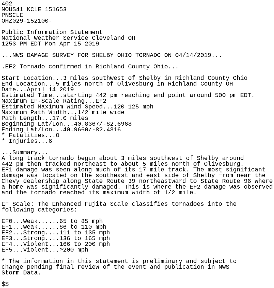
402
NOUS41 KCLE 151653
PNSCLE
OHZ029-152100-

Public Information Statement
National Weather Service Cleveland OH
1253 PM EDT Mon Apr 15 2019

...NWS DAMAGE SURVEY FOR SHELBY OHIO TORNADO ON 04/14/2019...

.EF2 Tornado confirmed in Richland County Ohio...

Start Location...3 miles southwest of Shelby in Richland County Ohio
End Location...5 miles north of Olivesburg in Richland County OH
Date...April 14 2019
Estimated Time...starting 442 pm reaching end point around 500 pm EDT.
Maximum EF-Scale Rating...EF2
Estimated Maximum Wind Speed...120-125 mph
Maximum Path Width...1/2 mile wide
Path Length...17.0 miles
Beginning Lat/Lon...40.8367/-82.6968
Ending Lat/Lon...40.9660/-82.4316
* Fatalities...0
* Injuries...6

...Summary...
A long track tornado began about 3 miles southwest of Shelby around
442 pm then tracked northeast to about 5 miles north of Olivesburg.
EF1 damage was seen along much of its 17 mile track. The most significant
damage was located on the southeast and east side of Shelby from near the
Chevy dealership along State Route 39 northeastward to State Route 96 where
a home was significantly damaged. This is where the EF2 damage was observed
and the tornado reached its maximum width of 1/2 mile.

EF Scale: The Enhanced Fujita Scale classifies tornadoes into the
following categories:

EF0...Weak......65 to 85 mph
EF1...Weak......86 to 110 mph
EF2...Strong....111 to 135 mph
EF3...Strong....136 to 165 mph
EF4...Violent...166 to 200 mph
EF5...Violent...>200 mph

* The information in this statement is preliminary and subject to
change pending final review of the event and publication in NWS
Storm Data.

$$