National Weather Service Raw Text Product
Displaying AFOS PIL: PNSLIX Product Timestamp: 2019-04-14 21:08 UTC
Previous in Time Latest Product Next in Time
View All KLIX Products for 14 Apr 2019 View All PNS Products for 14 Apr 2019 View As Image Download As Text
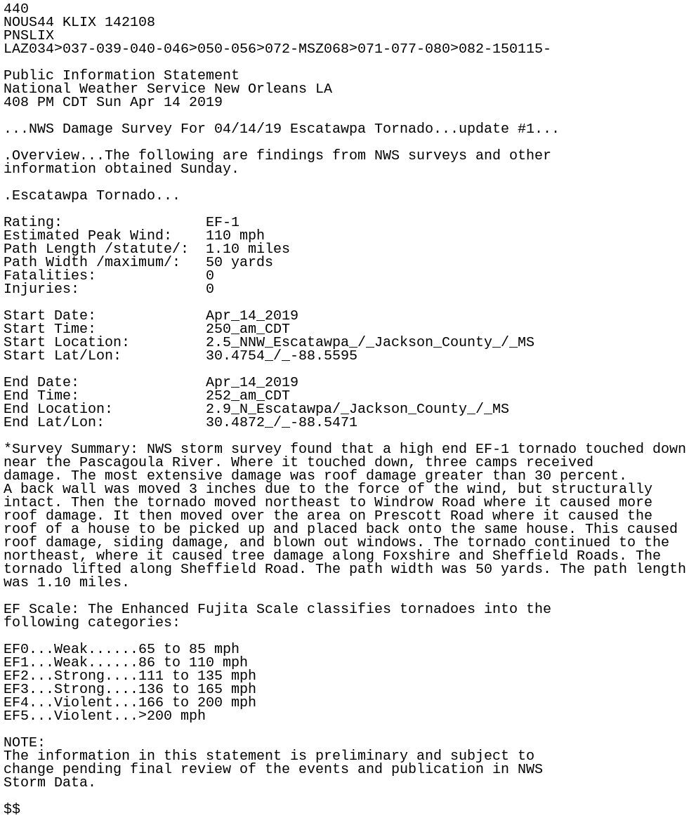
440
NOUS44 KLIX 142108
PNSLIX
LAZ034>037-039-040-046>050-056>072-MSZ068>071-077-080>082-150115-

Public Information Statement
National Weather Service New Orleans LA
408 PM CDT Sun Apr 14 2019

...NWS Damage Survey For 04/14/19 Escatawpa Tornado...update #1...

.Overview...The following are findings from NWS surveys and other
information obtained Sunday.

.Escatawpa Tornado...

Rating:                 EF-1
Estimated Peak Wind:    110 mph
Path Length /statute/:  1.10 miles
Path Width /maximum/:   50 yards
Fatalities:             0
Injuries:               0

Start Date:             Apr_14_2019
Start Time:             250_am_CDT
Start Location:         2.5_NNW_Escatawpa_/_Jackson_County_/_MS
Start Lat/Lon:          30.4754_/_-88.5595

End Date:               Apr_14_2019
End Time:               252_am_CDT
End Location:           2.9_N_Escatawpa/_Jackson_County_/_MS
End Lat/Lon:            30.4872_/_-88.5471

*Survey Summary: NWS storm survey found that a high end EF-1 tornado touched down
near the Pascagoula River. Where it touched down, three camps received
damage. The most extensive damage was roof damage greater than 30 percent.
A back wall was moved 3 inches due to the force of the wind, but structurally
intact. Then the tornado moved northeast to Windrow Road where it caused more
roof damage. It then moved over the area on Prescott Road where it caused the
roof of a house to be picked up and placed back onto the same house. This caused
roof damage, siding damage, and blown out windows. The tornado continued to the
northeast, where it caused tree damage along Foxshire and Sheffield Roads. The
tornado lifted along Sheffield Road. The path width was 50 yards. The path length
was 1.10 miles.

EF Scale: The Enhanced Fujita Scale classifies tornadoes into the
following categories:

EF0...Weak......65 to 85 mph
EF1...Weak......86 to 110 mph
EF2...Strong....111 to 135 mph
EF3...Strong....136 to 165 mph
EF4...Violent...166 to 200 mph
EF5...Violent...>200 mph

NOTE:
The information in this statement is preliminary and subject to
change pending final review of the events and publication in NWS
Storm Data.

$$