National Weather Service Raw Text Product
Displaying AFOS PIL: PNSIWX Product Timestamp: 2018-07-23 17:35 UTC
Previous in Time Latest Product Next in Time
View All KIWX Products for 23 Jul 2018 View All PNS Products for 23 Jul 2018 View As Image Download As Text
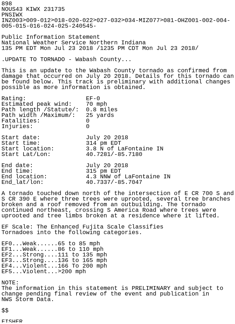
898
NOUS43 KIWX 231735
PNSIWX
INZ003>009-012>018-020-022>027-032>034-MIZ077>081-OHZ001-002-004-
005-015-016-024-025-240545-

Public Information Statement
National Weather Service Northern Indiana
135 PM EDT Mon Jul 23 2018 /1235 PM CDT Mon Jul 23 2018/

.UPDATE TO TORNADO - Wabash County...

This is an update to the Wabash County tornado as confirmed from
damage that occurred on July 20 2018. Details for this tornado can
be found below. This track is preliminary with additional changes
possible as more information is obtained.

Rating:                 EF-0
Estimated peak wind:    70 mph
Path length /Statute/:  0.8 miles
Path width /Maximum/:   25 yards
Fatalities:             0
Injuries:               0

Start date:             July 20 2018
Start time:             314 pm EDT
Start location:         3.8 N of LaFontaine IN
Start Lat/Lon:          40.7281/-85.7180

End date:               July 20 2018
End time:               315 pm EDT
End location:           4.3 NNW of LaFontaine IN
End_lat/lon:            40.7337/-85.7047

A tornado touched down north of the intersection of E CR 700 S and
S CR 390 E where three trees were uprooted, several tree branches
broken and a roof removed from an outbuilding. The tornado
continued northeast, crossing S America Road where trees were
uprooted and tree limbs broken at a residence where it lifted.

EF Scale: The Enhanced Fujita Scale Classifies
Tornadoes into the following categories.

EF0...Weak......65 to 85 mph
EF1...Weak......86 to 110 mph
EF2...Strong....111 to 135 mph
EF3...Strong....136 to 165 mph
EF4...Violent...166 To 200 mph
EF5...Violent...>200 mph

NOTE:
The information in this statement is PRELIMINARY and subject to
change pending final review of the event and publication in
NWS Storm Data.

$$

FISHER