National Weather Service Raw Text Product
Displaying AFOS PIL: PNSUNR Product Timestamp: 2018-07-03 21:37 UTC
Previous in Time Latest Product Next in Time
View All KUNR Products for 03 Jul 2018 View All PNS Products for 03 Jul 2018 View As Image Download As Text
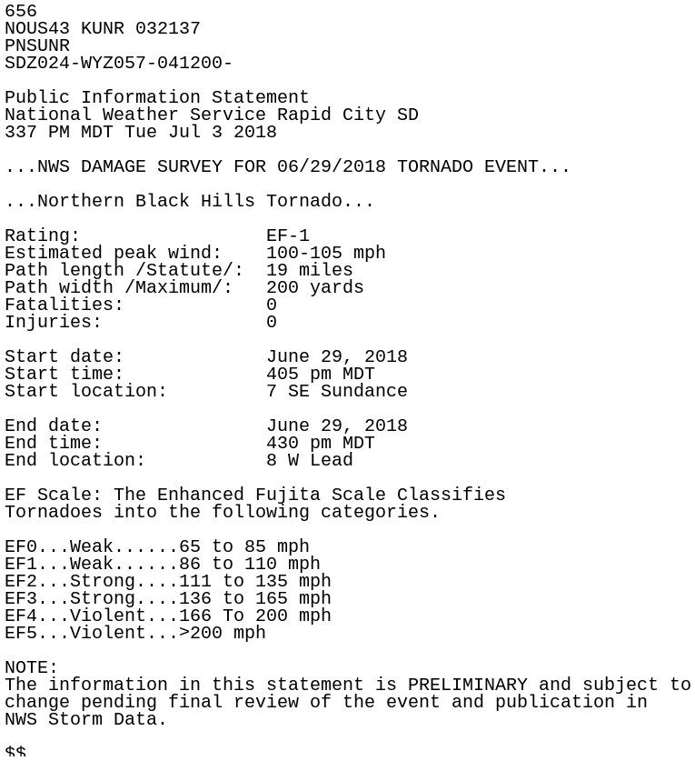
656
NOUS43 KUNR 032137
PNSUNR
SDZ024-WYZ057-041200-

Public Information Statement
National Weather Service Rapid City SD
337 PM MDT Tue Jul 3 2018

...NWS DAMAGE SURVEY FOR 06/29/2018 TORNADO EVENT...

...Northern Black Hills Tornado...

Rating:                 EF-1
Estimated peak wind:    100-105 mph
Path length /Statute/:  19 miles
Path width /Maximum/:   200 yards
Fatalities:             0
Injuries:               0

Start date:             June 29, 2018
Start time:             405 pm MDT
Start location:         7 SE Sundance

End date:               June 29, 2018
End time:               430 pm MDT
End location:           8 W Lead

EF Scale: The Enhanced Fujita Scale Classifies
Tornadoes into the following categories.

EF0...Weak......65 to 85 mph
EF1...Weak......86 to 110 mph
EF2...Strong....111 to 135 mph
EF3...Strong....136 to 165 mph
EF4...Violent...166 To 200 mph
EF5...Violent...>200 mph

NOTE:
The information in this statement is PRELIMINARY and subject to
change pending final review of the event and publication in
NWS Storm Data.

$$