National Weather Service Raw Text Product
Found 2 products at the given pil and timestamp. Scroll down to see them all.
Displaying AFOS PIL: PNSALY Product Timestamp: 2018-05-16 22:20 UTC
Previous in Time Latest Product Next in Time
View All KALY Products for 16 May 2018 View All PNS Products for 16 May 2018 View As Image Download As Text
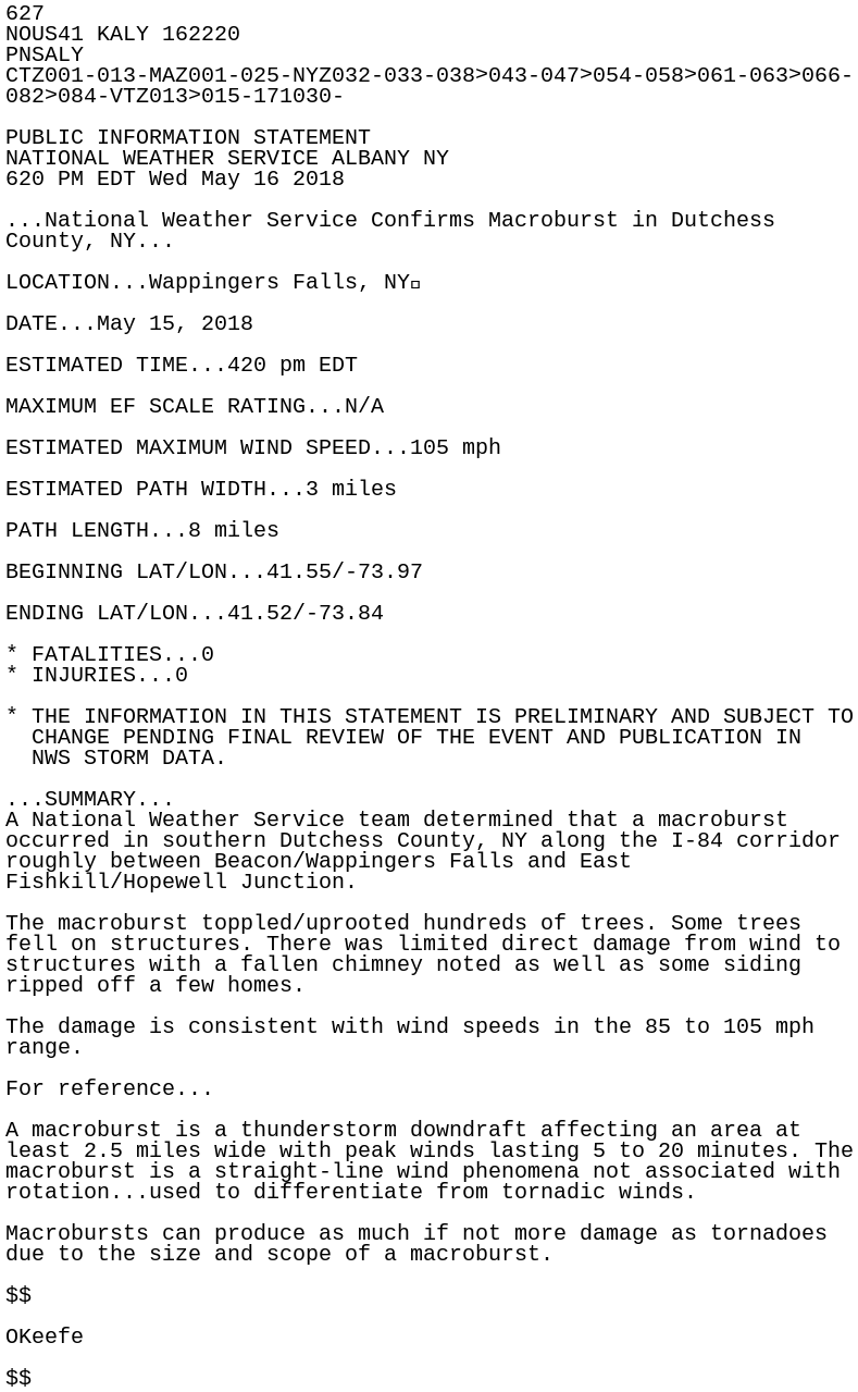
627
NOUS41 KALY 162220
PNSALY
CTZ001-013-MAZ001-025-NYZ032-033-038>043-047>054-058>061-063>066-
082>084-VTZ013>015-171030-

PUBLIC INFORMATION STATEMENT
NATIONAL WEATHER SERVICE ALBANY NY
620 PM EDT Wed May 16 2018

...National Weather Service Confirms Macroburst in Dutchess
County, NY...

LOCATION...Wappingers Falls, NY

DATE...May 15, 2018

ESTIMATED TIME...420 pm EDT

MAXIMUM EF SCALE RATING...N/A

ESTIMATED MAXIMUM WIND SPEED...105 mph

ESTIMATED PATH WIDTH...3 miles

PATH LENGTH...8 miles

BEGINNING LAT/LON...41.55/-73.97

ENDING LAT/LON...41.52/-73.84

* FATALITIES...0
* INJURIES...0

* THE INFORMATION IN THIS STATEMENT IS PRELIMINARY AND SUBJECT TO
  CHANGE PENDING FINAL REVIEW OF THE EVENT AND PUBLICATION IN
  NWS STORM DATA.

...SUMMARY...
A National Weather Service team determined that a macroburst
occurred in southern Dutchess County, NY along the I-84 corridor
roughly between Beacon/Wappingers Falls and East
Fishkill/Hopewell Junction.

The macroburst toppled/uprooted hundreds of trees. Some trees
fell on structures. There was limited direct damage from wind to
structures with a fallen chimney noted as well as some siding
ripped off a few homes.

The damage is consistent with wind speeds in the 85 to 105 mph
range.

For reference...

A macroburst is a thunderstorm downdraft affecting an area at
least 2.5 miles wide with peak winds lasting 5 to 20 minutes. The
macroburst is a straight-line wind phenomena not associated with
rotation...used to differentiate from tornadic winds.

Macrobursts can produce as much if not more damage as tornadoes
due to the size and scope of a macroburst.

$$

OKeefe

$$