National Weather Service Raw Text Product
Displaying AFOS PIL: EWWMFL Product Timestamp: 2017-09-10 16:25 UTC
Previous in Time Latest Product Next in Time
View All KMFL Products for 10 Sep 2017 View All EWW Products for 10 Sep 2017 View As Image Download As Text
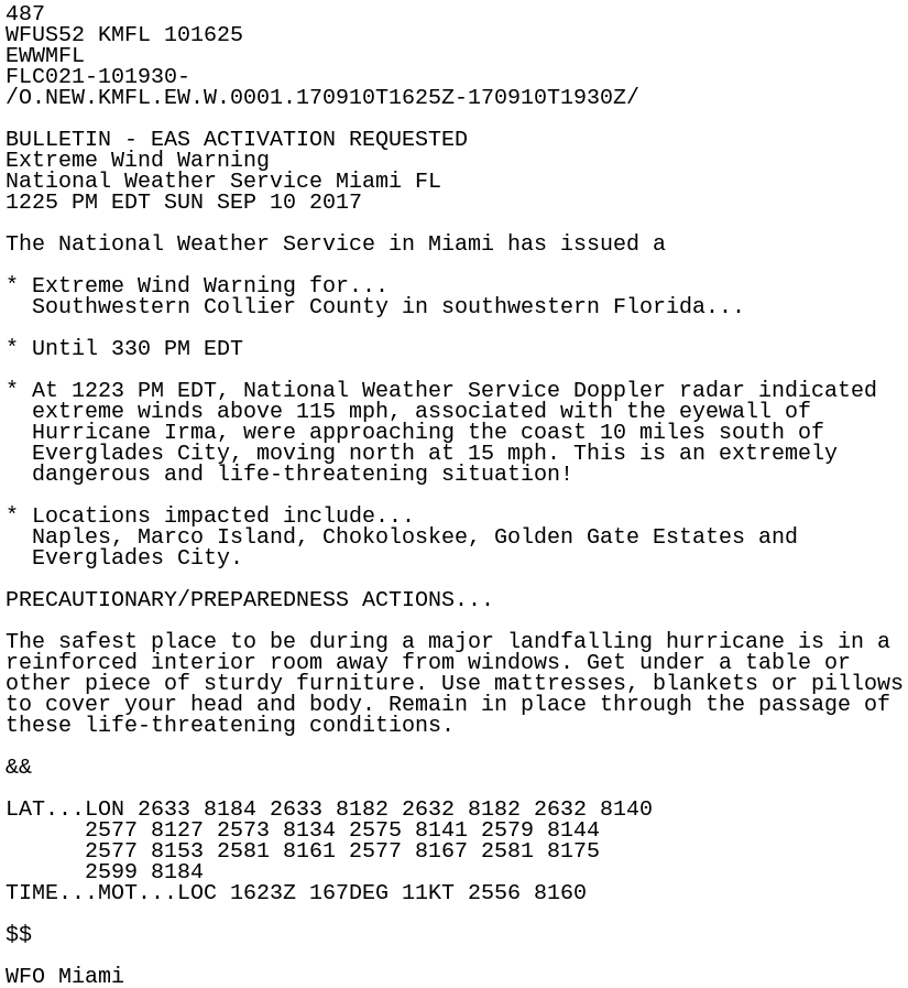
487
WFUS52 KMFL 101625
EWWMFL
FLC021-101930-
/O.NEW.KMFL.EW.W.0001.170910T1625Z-170910T1930Z/

BULLETIN - EAS ACTIVATION REQUESTED
Extreme Wind Warning
National Weather Service Miami FL
1225 PM EDT SUN SEP 10 2017

The National Weather Service in Miami has issued a

* Extreme Wind Warning for...
  Southwestern Collier County in southwestern Florida...

* Until 330 PM EDT

* At 1223 PM EDT, National Weather Service Doppler radar indicated
  extreme winds above 115 mph, associated with the eyewall of
  Hurricane Irma, were approaching the coast 10 miles south of
  Everglades City, moving north at 15 mph. This is an extremely
  dangerous and life-threatening situation!

* Locations impacted include...
  Naples, Marco Island, Chokoloskee, Golden Gate Estates and
  Everglades City.

PRECAUTIONARY/PREPAREDNESS ACTIONS...

The safest place to be during a major landfalling hurricane is in a
reinforced interior room away from windows. Get under a table or
other piece of sturdy furniture. Use mattresses, blankets or pillows
to cover your head and body. Remain in place through the passage of
these life-threatening conditions.

&&

LAT...LON 2633 8184 2633 8182 2632 8182 2632 8140
      2577 8127 2573 8134 2575 8141 2579 8144
      2577 8153 2581 8161 2577 8167 2581 8175
      2599 8184
TIME...MOT...LOC 1623Z 167DEG 11KT 2556 8160

$$

WFO Miami