National Weather Service Raw Text Product
Displaying AFOS PIL: PNSAKQ Product Timestamp: 2017-04-01 19:05 UTC
Previous in Time Latest Product Next in Time
View All KAKQ Products for 01 Apr 2017 View All PNS Products for 01 Apr 2017 View As Image Download As Text
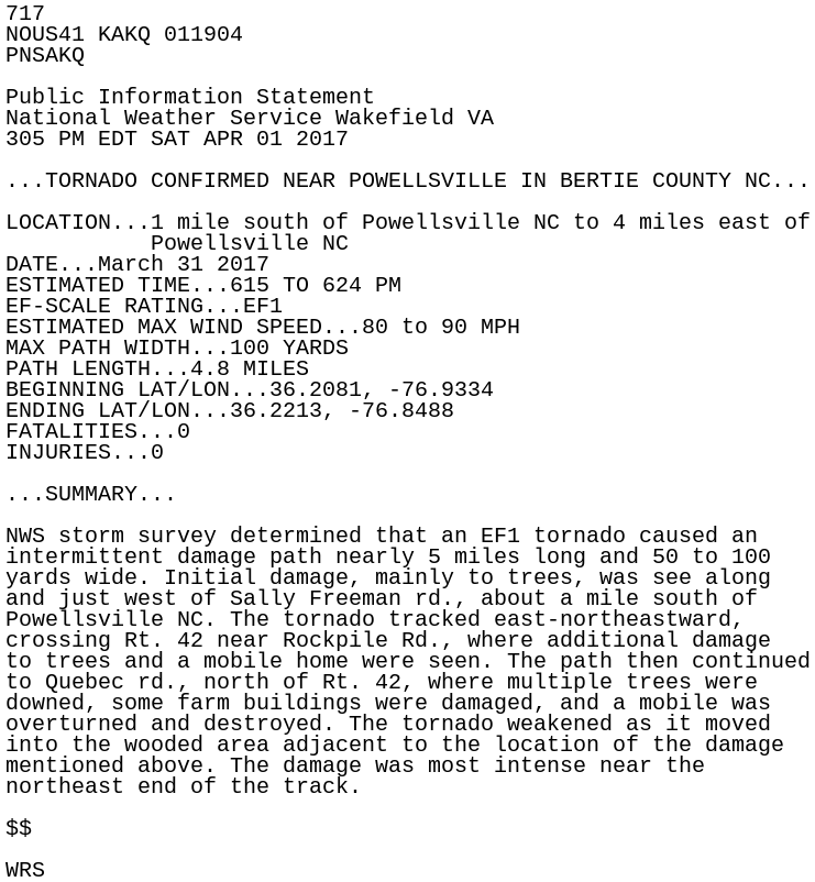
717
NOUS41 KAKQ 011904
PNSAKQ

Public Information Statement
National Weather Service Wakefield VA
305 PM EDT SAT APR 01 2017

...TORNADO CONFIRMED NEAR POWELLSVILLE IN BERTIE COUNTY NC...

LOCATION...1 mile south of Powellsville NC to 4 miles east of
           Powellsville NC
DATE...March 31 2017
ESTIMATED TIME...615 TO 624 PM
EF-SCALE RATING...EF1
ESTIMATED MAX WIND SPEED...80 to 90 MPH
MAX PATH WIDTH...100 YARDS
PATH LENGTH...4.8 MILES
BEGINNING LAT/LON...36.2081, -76.9334
ENDING LAT/LON...36.2213, -76.8488
FATALITIES...0
INJURIES...0

...SUMMARY...

NWS storm survey determined that an EF1 tornado caused an
intermittent damage path nearly 5 miles long and 50 to 100
yards wide. Initial damage, mainly to trees, was see along
and just west of Sally Freeman rd., about a mile south of
Powellsville NC. The tornado tracked east-northeastward,
crossing Rt. 42 near Rockpile Rd., where additional damage
to trees and a mobile home were seen. The path then continued
to Quebec rd., north of Rt. 42, where multiple trees were
downed, some farm buildings were damaged, and a mobile was
overturned and destroyed. The tornado weakened as it moved
into the wooded area adjacent to the location of the damage
mentioned above. The damage was most intense near the
northeast end of the track.

$$

WRS