National Weather Service Raw Text Product
Displaying AFOS PIL: PNSFWD Product Timestamp: 2021-04-29 16:30 UTC
Previous in Time Latest Product Next in Time
View All KFWD Products for 29 Apr 2021 View All PNS Products for 29 Apr 2021 View As Image Download As Text
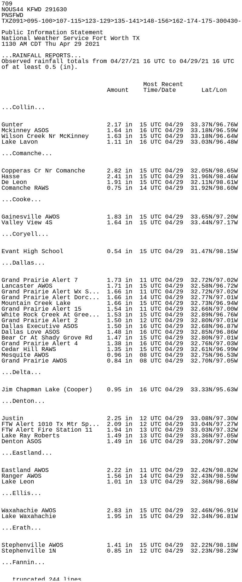
709
NOUS44 KFWD 291630
PNSFWD
TXZ091>095-100>107-115>123-129>135-141>148-156>162-174-175-300430-

Public Information Statement
National Weather Service Fort Worth TX
1130 AM CDT Thu Apr 29 2021

...RAINFALL REPORTS...
Observed rainfall totals from 04/27/21 16 UTC to 04/29/21 16 UTC
of at least 0.5 (in).


                                       Most Recent
                             Amount    Time/Date       Lat/Lon


...Collin...


Gunter                       2.17 in  15 UTC 04/29  33.37N/96.76W
Mckinney ASOS                1.64 in  16 UTC 04/29  33.18N/96.59W
Wilson Creek Nr McKinney     1.63 in  15 UTC 04/29  33.18N/96.64W
Lake Lavon                   1.11 in  16 UTC 04/29  33.03N/96.48W

...Comanche...


Copperas Cr Nr Comanche      2.82 in  15 UTC 04/29  32.05N/98.65W
Hasse                        2.41 in  15 UTC 04/29  31.96N/98.46W
De Leon                      1.91 in  15 UTC 04/29  32.11N/98.61W
Comanche RAWS                0.75 in  14 UTC 04/29  31.92N/98.60W

...Cooke...


Gainesville AWOS             1.83 in  15 UTC 04/29  33.65N/97.20W
Valley View 4S               1.64 in  15 UTC 04/29  33.44N/97.17W

...Coryell...


Evant High School            0.54 in  15 UTC 04/29  31.47N/98.15W

...Dallas...


Grand Prairie Alert 7        1.73 in  11 UTC 04/29  32.72N/97.02W
Lancaster AWOS               1.71 in  15 UTC 04/29  32.58N/96.72W
Grand Prairie Alert Wx S...  1.66 in  11 UTC 04/29  32.72N/97.02W
Grand Prairie Alert Dorc...  1.66 in  14 UTC 04/29  32.77N/97.01W
Mountain Creek Lake          1.66 in  15 UTC 04/29  32.73N/96.94W
Grand Prairie Alert 15       1.54 in  11 UTC 04/29  32.66N/97.00W
White Rock Creek At Gree...  1.53 in  15 UTC 04/29  32.89N/96.76W
Grand Prairie Alert 2        1.50 in  12 UTC 04/29  32.80N/97.01W
Dallas Executive ASOS        1.50 in  16 UTC 04/29  32.68N/96.87W
Dallas Love ASOS             1.48 in  16 UTC 04/29  32.85N/96.86W
Bear Cr At Shady Grove Rd    1.47 in  15 UTC 04/29  32.80N/97.01W
Grand Prairie Alert 4        1.38 in  16 UTC 04/29  32.76N/97.03W
Cedar Hill RAWS              1.35 in  15 UTC 04/29  32.61N/96.99W
Mesquite AWOS                0.96 in  08 UTC 04/29  32.75N/96.53W
Grand Prairie AWOS           0.84 in  08 UTC 04/29  32.70N/97.05W

...Delta...


Jim Chapman Lake (Cooper)    0.95 in  16 UTC 04/29  33.33N/95.63W

...Denton...


Justin                       2.25 in  12 UTC 04/29  33.08N/97.30W
FTW Alert 1010 Tx Mtr Sp...  2.09 in  12 UTC 04/29  33.04N/97.27W
FTW Alert Fire Station 11    1.94 in  13 UTC 04/29  33.03N/97.32W
Lake Ray Roberts             1.49 in  13 UTC 04/29  33.36N/97.05W
Denton ASOS                  1.49 in  16 UTC 04/29  33.20N/97.20W

...Eastland...


Eastland AWOS                2.22 in  11 UTC 04/29  32.42N/98.82W
Ranger AWOS                  1.56 in  14 UTC 04/29  32.43N/98.59W
Lake Leon                    1.01 in  13 UTC 04/29  32.36N/98.68W

...Ellis...


Waxahachie AWOS              2.83 in  15 UTC 04/29  32.46N/96.91W
Lake Waxahachie              1.95 in  15 UTC 04/29  32.34N/96.81W

...Erath...


Stephenville AWOS            1.41 in  15 UTC 04/29  32.22N/98.18W
Stephenville 1N              0.85 in  12 UTC 04/29  32.23N/98.23W

...Fannin...


Bonham 3NNE                  4.30 in  12 UTC 04/29  33.64N/96.17W
Bonham AWOS                  3.44 in  14 UTC 04/29  33.61N/96.18W
Caddo Grasslands RAWS        3.12 in  15 UTC 04/29  33.75N/95.93W
Ladonia                      1.47 in  15 UTC 04/29  33.42N/95.94W

...Grayson...


Desert Water Coop#2 Hw160    3.26 in  15 UTC 04/29  33.43N/96.40W
Collinsville                 1.21 in  15 UTC 04/29  33.53N/96.81W
Sherman/denison AWOS         1.08 in  10 UTC 04/29  33.71N/96.67W

...Hamilton...


Hamilton AWOS                1.04 in  15 UTC 04/29  31.67N/98.15W

...Hill...


Covington                    4.98 in  15 UTC 04/29  32.19N/97.26W

...Hood...


Lipan                        2.10 in  12 UTC 04/29  32.52N/98.05W
Lake Granbury                1.22 in  13 UTC 04/29  32.37N/97.69W
Granbury RAWS                0.58 in  15 UTC 04/29  32.45N/97.82W
Granbury AWOS                0.57 in  15 UTC 04/29  32.44N/97.82W

...Hopkins...


Cumby                        1.96 in  12 UTC 04/29  33.16N/95.84W
Sulphur Springs              1.70 in  12 UTC 04/29  33.15N/95.63W
Sulphur Bluff                1.53 in  15 UTC 04/29  33.33N/95.40W
Sulphur Springs AWOS         1.06 in  15 UTC 04/29  33.16N/95.62W

...Hunt...


Greenville AWOS              2.75 in  14 UTC 04/29  33.07N/96.07W
Commerce                     1.84 in  15 UTC 04/29  33.27N/95.92W
Greenville RAWS              1.83 in  15 UTC 04/29  33.04N/96.16W
Celeste                      1.34 in  15 UTC 04/29  33.30N/96.24W

...Jack...


Bear Mtn Reptr (Postoak)     2.84 in  16 UTC 04/29  33.39N/98.21W
Truce                        2.78 in  16 UTC 04/29  33.41N/98.01W
Lake Bridgeport Repeater     2.01 in  16 UTC 04/29  33.20N/98.00W
Wizard Wells                 1.94 in  16 UTC 04/29  33.20N/97.97W
Joplin                       0.87 in  16 UTC 04/29  33.09N/97.99W
Jacksboro                    0.73 in  12 UTC 04/29  33.24N/98.15W
Jacksboro                    0.52 in  16 UTC 04/29  33.29N/98.08W

...Johnson...


Venus                        2.12 in  15 UTC 04/29  32.49N/97.12W
FTW Alert Alvarado           1.79 in  13 UTC 04/29  32.42N/97.22W
FTW Alert Cresson            1.23 in  13 UTC 04/29  32.53N/97.61W
Keene                        1.17 in  12 UTC 04/29  32.42N/97.34W
Cleburne AWOS                1.14 in  15 UTC 04/29  32.35N/97.43W
FTW Alert Godley             0.99 in  13 UTC 04/29  32.45N/97.53W
FTW Alert Joshua             0.86 in  13 UTC 04/29  32.46N/97.39W

...Kaufman...


Terrell ASOS                 1.80 in  16 UTC 04/29  32.71N/96.27W

...Lamar...


Paris AWOS                   2.72 in  14 UTC 04/29  33.64N/95.45W
Roxton                       1.84 in  15 UTC 04/29  33.54N/95.72W
Pat Mayse Dam                1.39 in  15 UTC 04/29  33.85N/95.54W
Cooper                       1.03 in  15 UTC 04/29  33.47N/95.59W

...Lampasas...


Lampasas Airport AWOS        1.06 in  15 UTC 04/29  31.11N/98.20W

...Mills...


Browns Creek Nr Goldthwa...  0.59 in  15 UTC 04/29  31.52N/98.57W

...Montague...


Lake Amon Carter             2.22 in  15 UTC 04/29  33.47N/97.86W
Montague                     1.42 in  15 UTC 04/29  33.65N/97.76W

...Palo Pinto...


Possum Kingdom RAWS          2.85 in  15 UTC 04/29  32.87N/98.55W
Palo Pinto                   1.28 in  13 UTC 04/29  32.86N/98.30W
Possum Kingdom Lake          1.18 in  15 UTC 04/29  32.87N/98.43W

...Parker...


Mineral Wells ASOS           2.96 in  16 UTC 04/29  32.78N/98.06W
Weatherford                  2.15 in  12 UTC 04/29  32.75N/97.77W
FTW Alert Springtown Hig...  2.15 in  16 UTC 04/29  32.98N/97.69W
Springtown 4S                2.05 in  16 UTC 04/29  32.91N/97.68W
FTW Alert Walsh Ranch Pu...  1.91 in  13 UTC 04/29  32.72N/97.59W
FTW Alert Annetta            1.33 in  13 UTC 04/29  32.67N/97.65W
Cresson - Bourland Field...  1.15 in  15 UTC 04/29  32.59N/97.59W
Dennis                       1.05 in  15 UTC 04/29  32.62N/97.93W
Weatherford                  0.94 in  15 UTC 04/29  32.74N/97.65W
Agnes                        0.93 in  16 UTC 04/29  32.98N/97.79W

...Rains...


Lake Tawakoni                0.85 in  15 UTC 04/29  32.81N/95.92W

...Rockwall...


Rockwall Airport AWOS        1.74 in  11 UTC 04/29  32.93N/96.44W

...Somervell...


Glen Rose                    1.93 in  15 UTC 04/29  32.23N/97.78W

...Stephens...


Breckenridge AWOS            2.55 in  15 UTC 04/29  32.72N/98.89W

...Tarrant...


Fort Worth Alert 1030        3.12 in  15 UTC 04/29  32.82N/97.45W
Keller                       3.08 in  12 UTC 04/29  32.97N/97.21W
FTW Alert 2600 Heron Dr ...  2.84 in  12 UTC 04/29  32.79N/97.49W
FTW Alert Fort Worth CAS...  2.76 in  13 UTC 04/29  32.84N/97.43W
FTW Alert 3500 Las Vegas...  2.68 in  15 UTC 04/29  32.78N/97.47W
FTW ALert 3900 Academy B...  2.45 in  13 UTC 04/29  32.75N/97.49W
FTW Alert Fire Station 38    2.40 in  13 UTC 04/29  32.97N/97.26W
FTW Alert 3100 Golden Tr...  2.26 in  12 UTC 04/29  32.93N/97.28W
FTW Alliance ASOS            2.24 in  16 UTC 04/29  32.99N/97.32W
FTW Alert 1060 Como Lake     2.17 in  12 UTC 04/29  32.73N/97.40W
Grand Prairie Alert 12       2.10 in  15 UTC 04/29  32.68N/97.04W
Eagle Mtn Balancing Rsvr     2.08 in  16 UTC 04/29  32.75N/97.52W
FTW Alert North Service ...  1.97 in  13 UTC 04/29  32.93N/97.36W
FTW Alert Fire Station 1     1.91 in  13 UTC 04/29  32.76N/97.33W
Eagle Mtn Repeater           1.87 in  16 UTC 04/29  32.86N/97.50W
FTW Alert 1020 Longstraw...  1.86 in  12 UTC 04/29  32.87N/97.29W
FTW Alert 1070 Fosdic Lake   1.86 in  12 UTC 04/29  32.76N/97.26W
FTW Alert 2050 36th St       1.86 in  11 UTC 04/29  32.81N/97.33W
Grand Prairie Alert 14       1.82 in  16 UTC 04/29  32.66N/97.04W
FTW Alert Fire Station 31    1.78 in  13 UTC 04/29  32.87N/97.29W
FTW Alert 1400 Haltom Rd     1.75 in  12 UTC 04/29  32.78N/97.28W
Mansfield                    1.69 in  16 UTC 04/29  32.58N/97.10W
Haltom City                  1.69 in  15 UTC 04/29  32.81N/97.25W
FTW Alert 1300 Trinity B...  1.66 in  16 UTC 04/29  32.80N/97.20W
FTW Alert 3450 Mosier Va...  1.66 in  12 UTC 04/29  32.81N/97.11W
FTW Alert 1900 Vickery B...  1.66 in  12 UTC 04/29  32.74N/97.32W
FTW Alert 1500 Randol Mi...  1.59 in  11 UTC 04/29  32.78N/97.20W
FTW Alert Mansfield City...  1.57 in  13 UTC 04/29  32.56N/97.13W
DFW Airport ASOS             1.56 in  16 UTC 04/29  32.90N/97.02W
FTW Alert 900 Long Ave       1.54 in  11 UTC 04/29  32.81N/97.35W
Grand Prairie Alert Rive...  1.54 in  16 UTC 04/29  32.80N/97.06W
Fort Worth                   1.51 in  12 UTC 04/29  32.70N/97.44W
Arlington ASOS               1.56 in  16 UTC 04/29  32.66N/97.10W
FTW Alert 2000 Collard St    1.50 in  13 UTC 04/29  32.74N/97.28W
FTW Alert 300 Trinity Blvd   1.47 in  12 UTC 04/29  32.80N/97.15W
Marys Creek                  1.47 in  15 UTC 04/29  32.70N/97.45W
Marine Creek Lake            1.43 in  16 UTC 04/29  32.82N/97.39W
FTW Meacham ASOS             1.43 in  16 UTC 04/29  32.82N/97.35W
TRWD Sump 3                  1.40 in  16 UTC 04/29  32.77N/97.41W
FTW Alert 600 Macie Ave      1.40 in  15 UTC 04/29  32.81N/97.37W
FTW Alert 3800 Golden He...  1.39 in  12 UTC 04/29  32.93N/97.33W
Grand Prairie Alert 9        1.38 in  11 UTC 04/29  32.71N/97.04W
Grand Prairie Alert 3        1.38 in  12 UTC 04/29  32.77N/97.06W
FTW Alert Village Creek ...  1.35 in  13 UTC 04/29  32.79N/97.14W
FTW Alert 3200 DeRidder ...  1.30 in  12 UTC 04/29  32.82N/97.34W
Lake Benbrook                1.29 in  16 UTC 04/29  32.65N/97.45W
FTW Alert Ventana Pump S...  1.28 in  13 UTC 04/29  32.68N/97.50W
Rush Crk at Pleasant Rid...  1.27 in  11 UTC 04/29  32.68N/97.16W
FTW Alert 1100 28th and ...  1.26 in  11 UTC 04/29  32.80N/97.34W
TRWD SUMP 6 ALERT            1.22 in  16 UTC 04/29  32.76N/97.40W
Arlington - Rush Crk at ...  1.22 in  11 UTC 04/29  32.72N/97.17W
TRWD Sump 8                  1.22 in  16 UTC 04/29  32.75N/97.39W
FTW Alert 2700 James Ave     1.19 in  11 UTC 04/29  32.67N/97.35W
TRWD SUMP 5 ALERT            1.19 in  16 UTC 04/29  32.75N/97.40W
Grand Prairie Alert 8        1.18 in  11 UTC 04/29  32.73N/97.04W
TRWD Sump 17                 1.16 in  16 UTC 04/29  32.72N/97.38W
TRWD SUMP 28 ALERT           1.15 in  16 UTC 04/29  32.78N/97.33W
Rush Crk at Sublett Rd       1.15 in  11 UTC 04/29  32.65N/97.15W
Lake Grapevine               1.12 in  15 UTC 04/29  32.97N/97.06W
Tarrant Rgnl Wtr Dist HQ     1.12 in  16 UTC 04/29  32.78N/97.34W
TRWD Sump 13                 1.12 in  16 UTC 04/29  32.77N/97.37W
TRWD Handley Ederville R...  1.11 in  16 UTC 04/29  32.78N/97.22W
FTW ALert 2253 West Semi...  1.11 in  16 UTC 04/29  32.68N/97.33W
Grand Prairie Alert 19       1.03 in  10 UTC 04/29  32.62N/97.04W
FTW Alert Chisholm Trail...  1.02 in  13 UTC 04/29  32.61N/97.41W
Cement Lake                  0.98 in  16 UTC 04/29  32.83N/97.37W
West Fork Trinity River ...  0.97 in  15 UTC 04/29  32.79N/97.14W
FTW Alert 2650 Eastland ...  0.96 in  12 UTC 04/29  32.71N/97.25W
FTW Alert 2300               0.95 in  16 UTC 04/29  32.58N/97.29W
FTW Alert 2950 Everman K...  0.91 in  11 UTC 04/29  32.64N/97.24W

...Van Zandt...


Wills Point                  0.55 in  12 UTC 04/29  32.70N/96.02W

...Wise...


Cottondale                   4.13 in  16 UTC 04/29  33.07N/97.70W
Bridgeport AWOS              1.78 in  15 UTC 04/29  33.18N/97.83W
Boonsville                   1.59 in  16 UTC 04/29  33.05N/97.83W
LBJ Grasslands RAWS          1.50 in  15 UTC 04/29  33.28N/97.63W
Bridgeport                   1.48 in  13 UTC 04/29  33.23N/97.69W
Decatur AWOS                 1.43 in  15 UTC 04/29  33.25N/97.58W
Garrett Creek Ranch          1.26 in  16 UTC 04/29  33.12N/97.73W
Alvord (Brushy Creek)        1.03 in  16 UTC 04/29  33.37N/97.72W
Paradise (Salt Creek)        0.95 in  16 UTC 04/29  33.10N/97.65W

...Young...


Eliasville                   2.06 in  16 UTC 04/29  32.96N/98.77W
South Bend                   1.30 in  15 UTC 04/29  33.02N/98.64W


Observations are collected from a variety of sources with varying
equipment and exposures. Not all data listed are considered
official. Any locations marked with an asterisk (*) may have
incomplete data during the valid time period.

$$