National Weather Service Raw Text Product
Displaying AFOS PIL: PNSLBF Product Timestamp: 2020-06-10 04:05 UTC
Previous in Time Latest Product Next in Time
View All KLBF Products for 10 Jun 2020 View All PNS Products for 10 Jun 2020 View As Image Download As Text
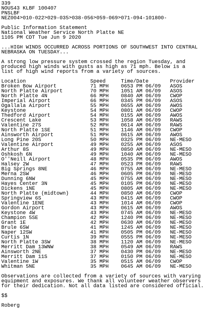
339
NOUS43 KLBF 100407
PNSLBF
NEZ004>010-022>029-035>038-056>059-069>071-094-101800-

Public Information Statement
National Weather Service North Platte NE
1105 PM CDT Tue Jun 9 2020

...HIGH WINDS OCCURRED ACROSS PORTIONS OF SOUTHWEST INTO CENTRAL
NEBRASKA ON TUESDAY...

A strong low pressure system crossed the region Tuesday, and
produced high winds with gusts as high as 71 mph. Below is a
list of high wind reports from a variety of sources.

Location                     Speed     Time/Date       Provider
Broken Bow Airport           71 MPH    0653 PM 06/09   ASOS
North Platte Airport         70 MPH    1051 AM 06/09   ASOS
North Platte 4N              66 MPH    0840 AM 06/09   CWOP
Imperial Airport             66 MPH    0345 PM 06/09   ASOS
Ogallala Airport             55 MPH    0655 AM 06/09   AWOS
Keystone                     54 MPH    0801 AM 06/09   CWOP
Thedford Airport             54 MPH    0155 AM 06/09   AWOS
Crescent Lake                53 MPH    1058 AM 06/09   RAWS
Valentine 27S                52 MPH    0614 AM 06/09   RAWS
North Platte 1SE             51 MPH    1146 AM 06/09   CWOP
Ainsworth Airport            51 MPH    0615 AM 06/09   AWOS
Long Pine 20S                50 MPH    0325 PM 06/09   NE-MESO
Valentine Airport            49 MPH    0255 AM 06/09   ASOS
Arthur 8S                    49 MPH    0850 AM 06/09   NE-MESO
Oshkosh 6N                   49 MPH    1040 AM 06/09   NE-MESO
O''Neill Airport             48 MPH    0535 PM 06/09   AWOS
Halsey 2W                    47 MPH    0523 PM 06/09   RAWS
Big Springs 8NE              46 MPH    0755 AM 06/09   NE-MESO
Merna 2SW                    46 MPH    0605 PM 06/09   NE-MESO
Dunning 6NW                  45 MPH    0755 AM 06/09   NE-MESO
Hayes Center 3N              45 MPH    0105 PM 06/09   NE-MESO
Dickens 1NE                  45 MPH    0805 AM 06/09   NE-MESO
North Platte (midtown)       44 MPH    0850 AM 06/09   CWOP
Springview 6S                43 MPH    0415 AM 06/09   CWOP
Valentine 1ENE               43 MPH    1014 AM 06/09   CWOP
Gordon Airport               43 MPH    0615 AM 06/09   AWOS
Keystone 4W                  43 MPH    0745 AM 06/09   NE-MESO
Champion 5SE                 42 MPH    1240 PM 06/09   NE-MESO
Grant 1E                     42 MPH    0630 AM 06/09   NE-MESO
Brule 6SW                    41 MPH    1245 AM 06/09   NE-MESO
Naper 12SW                   41 MPH    0505 PM 06/09   NE-MESO
Curtis 1N                    39 MPH    0555 PM 06/09   NE-MESO
North Platte 3SW             38 MPH    1120 AM 06/09   NE-MESO
Merritt Dam 13WNW            38 MPH    0549 AM 06/09   RAWS
Ainsworth 2NE                37 MPH    0430 PM 06/09   NE-MESO
Merritt Dam 11S              37 MPH    0150 PM 06/09   NE-MESO
Valentine 1W                 35 MPH    0515 AM 06/09   CWOP
Whitman 5NE                  35 MPH    0645 AM 06/09   NE-MESO

Observations are collected from a variety of sources with varying
equipment and exposures. We thank all volunteer weather observers
for their dedication. Not all data listed are considered official.

$$

Roberg