National Weather Service Raw Text Product
Displaying AFOS PIL: PNSIND Product Timestamp: 2020-04-09 21:00 UTC
Previous in Time Latest Product Next in Time
View All KIND Products for 09 Apr 2020 View All PNS Products for 09 Apr 2020 View As Image Download As Text
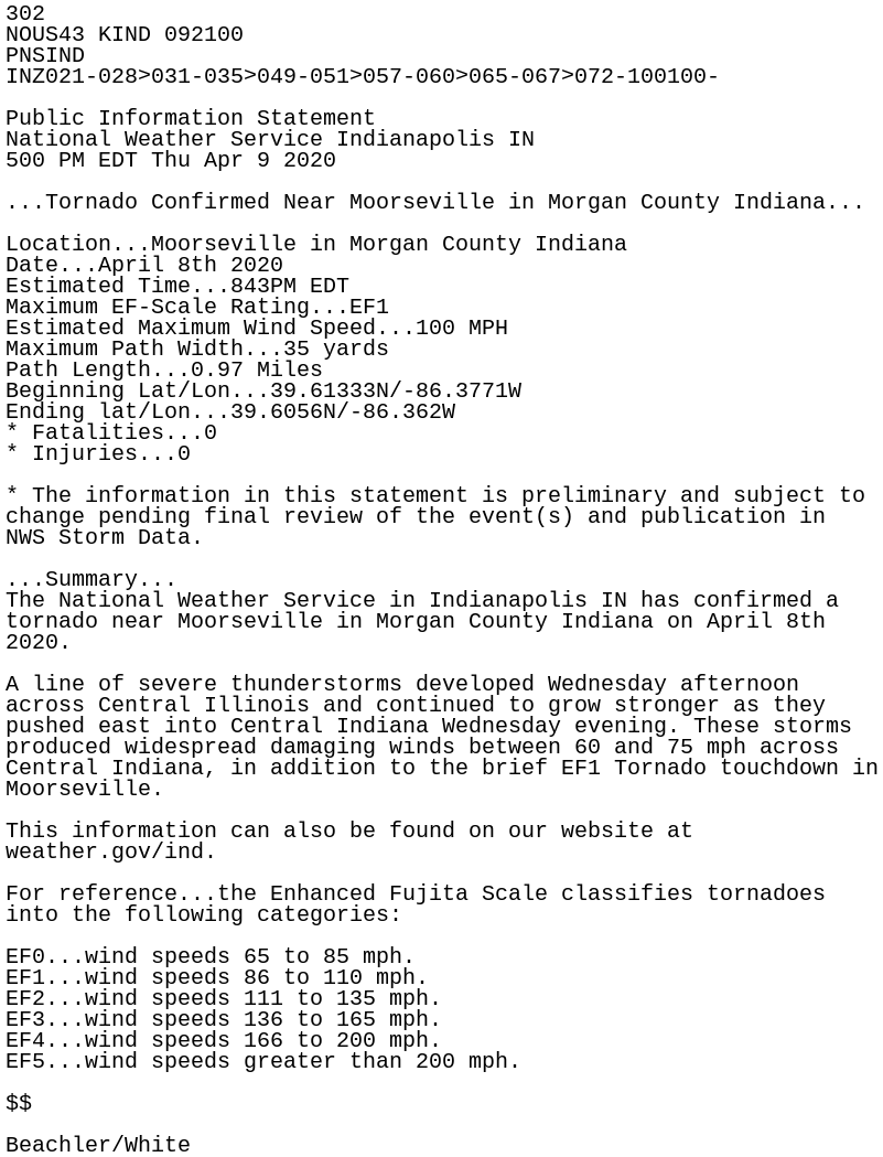
302
NOUS43 KIND 092100
PNSIND
INZ021-028>031-035>049-051>057-060>065-067>072-100100-

Public Information Statement
National Weather Service Indianapolis IN
500 PM EDT Thu Apr 9 2020

...Tornado Confirmed Near Moorseville in Morgan County Indiana...

Location...Moorseville in Morgan County Indiana
Date...April 8th 2020
Estimated Time...843PM EDT
Maximum EF-Scale Rating...EF1
Estimated Maximum Wind Speed...100 MPH
Maximum Path Width...35 yards
Path Length...0.97 Miles
Beginning Lat/Lon...39.61333N/-86.3771W
Ending lat/Lon...39.6056N/-86.362W
* Fatalities...0
* Injuries...0

* The information in this statement is preliminary and subject to
change pending final review of the event(s) and publication in
NWS Storm Data.

...Summary...
The National Weather Service in Indianapolis IN has confirmed a
tornado near Moorseville in Morgan County Indiana on April 8th
2020.

A line of severe thunderstorms developed Wednesday afternoon
across Central Illinois and continued to grow stronger as they
pushed east into Central Indiana Wednesday evening. These storms
produced widespread damaging winds between 60 and 75 mph across
Central Indiana, in addition to the brief EF1 Tornado touchdown in
Moorseville.

This information can also be found on our website at
weather.gov/ind.

For reference...the Enhanced Fujita Scale classifies tornadoes
into the following categories:

EF0...wind speeds 65 to 85 mph.
EF1...wind speeds 86 to 110 mph.
EF2...wind speeds 111 to 135 mph.
EF3...wind speeds 136 to 165 mph.
EF4...wind speeds 166 to 200 mph.
EF5...wind speeds greater than 200 mph.

$$

Beachler/White