National Weather Service Raw Text Product
Displaying AFOS PIL: PNSSHV Product Timestamp: 2017-03-26 16:13 UTC
Previous in Time Latest Product Next in Time
View All KSHV Products for 26 Mar 2017 View All PNS Products for 26 Mar 2017 View As Image Download As Text
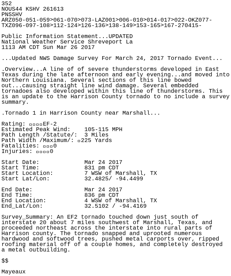
352
NOUS44 KSHV 261613
PNSSHV
ARZ050-051-059>061-070>073-LAZ001>006-010>014-017>022-OKZ077-
TXZ096-097-108>112-124>126-136>138-149>153-165>167-270415-

Public Information Statement...UPDATED
National Weather Service Shreveport La
1113 AM CDT Sun Mar 26 2017

...Updated NWS Damage Survey For March 24, 2017 Tornado Event...

.Overview...A line of of severe thunderstorms developed in East
Texas during the late afternoon and early evening...and moved into
Northern Louisiana. Several sections of this line bowed
out...causing straight line wind damage. Several embedded
tornadoes also developed within this line of thunderstorms. This
is an update to the Harrison County tornado to no include a survey
summary.

.Tornado 1 in Harrison County near Marshall...

Rating: 				EF-2
Estimated Peak Wind:    105-115 MPH
Path Length /Statute/:  3 Miles
Path Width /Maximum/: 	225 Yards
Fatalities: 			0
Injuries: 				0

Start Date:             Mar 24 2017
Start Time:             831 pm CDT
Start Location:         7 WSW of Marshall, TX
Start Lat/Lon:          32.4825/ -94.4499

End Date:               Mar 24 2017
End Time:               836 pm CDT
End Location:           4 WSW of Marshall, TX
End_Lat/Lon:            32.5102 / -94.4169

Survey_Summary: An EF2 tornado touched down just south of
interstate 20 about 7 miles southwest of Marshall, Texas, and
proceeded northeast across the interstate into rural parts of
Harrison county. The tornado snapped and uprooted numerous
hardwood and softwood trees, pushed metal carports over, ripped
roofing material off of a couple homes, and completely destroyed
a metal outbuilding.

$$

Mayeaux