National Weather Service Raw Text Product
Displaying AFOS PIL: PNSMEG Product Timestamp: 2022-01-02 21:53 UTC
Previous in Time Latest Product Next in Time
View All KMEG Products for 02 Jan 2022 View All PNS Products for 02 Jan 2022 View As Image Download As Text
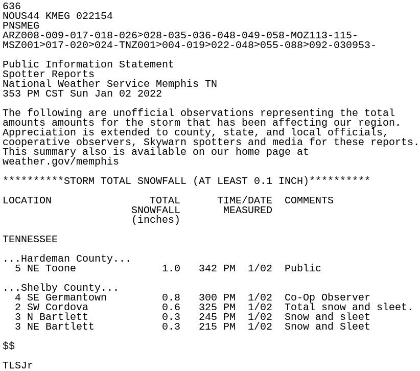
636
NOUS44 KMEG 022154
PNSMEG
ARZ008-009-017-018-026>028-035-036-048-049-058-MOZ113-115-
MSZ001>017-020>024-TNZ001>004-019>022-048>055-088>092-030953-

Public Information Statement
Spotter Reports
National Weather Service Memphis TN
353 PM CST Sun Jan 02 2022

The following are unofficial observations representing the total
amounts amounts for the storm that has been affecting our region.
Appreciation is extended to county, state, and local officials,
cooperative observers, Skywarn spotters and media for these reports.
This summary also is available on our home page at
weather.gov/memphis

**********STORM TOTAL SNOWFALL (AT LEAST 0.1 INCH)**********

LOCATION                TOTAL      TIME/DATE  COMMENTS
                     SNOWFALL       MEASURED
                     (inches)

TENNESSEE

...Hardeman County...
  5 NE Toone              1.0   342 PM  1/02  Public

...Shelby County...
  4 SE Germantown         0.8   300 PM  1/02  Co-Op Observer
  2 SW Cordova            0.6   325 PM  1/02  Total snow and sleet.
  3 N Bartlett            0.3   245 PM  1/02  Snow and sleet
  3 NE Bartlett           0.3   215 PM  1/02  Snow and Sleet

$$

TLSJr