National Weather Service Raw Text Product
Displaying AFOS PIL: PNSTBW Product Timestamp: 2020-04-20 18:54 UTC
Previous in Time Latest Product Next in Time
View All KTBW Products for 20 Apr 2020 View All PNS Products for 20 Apr 2020 View As Image Download As Text
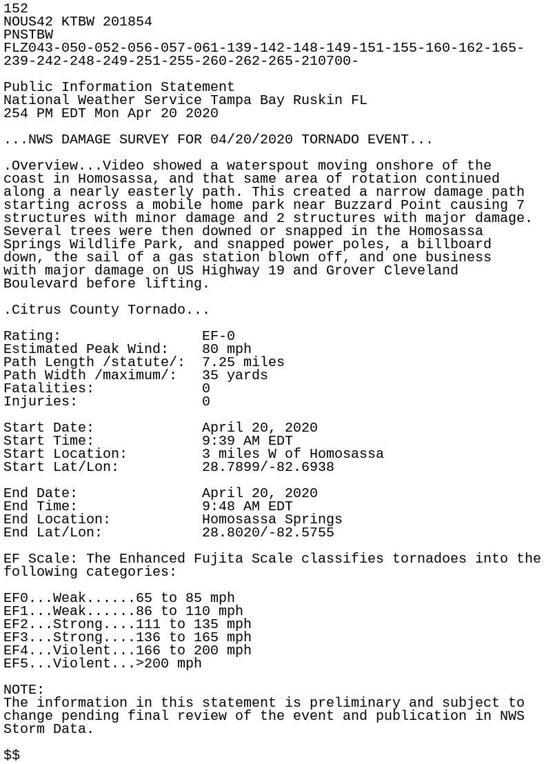
152
NOUS42 KTBW 201854
PNSTBW
FLZ043-050-052-056-057-061-139-142-148-149-151-155-160-162-165-
239-242-248-249-251-255-260-262-265-210700-

Public Information Statement
National Weather Service Tampa Bay Ruskin FL
254 PM EDT Mon Apr 20 2020

...NWS DAMAGE SURVEY FOR 04/20/2020 TORNADO EVENT...

.Overview...Video showed a waterspout moving onshore of the
coast in Homosassa, and that same area of rotation continued
along a nearly easterly path. This created a narrow damage path
starting across a mobile home park near Buzzard Point causing 7
structures with minor damage and 2 structures with major damage.
Several trees were then downed or snapped in the Homosassa
Springs Wildlife Park, and snapped power poles, a billboard
down, the sail of a gas station blown off, and one business
with major damage on US Highway 19 and Grover Cleveland
Boulevard before lifting.

.Citrus County Tornado...

Rating:                 EF-0
Estimated Peak Wind:    80 mph
Path Length /statute/:  7.25 miles
Path Width /maximum/:   35 yards
Fatalities:             0
Injuries:               0

Start Date:             April 20, 2020
Start Time:             9:39 AM EDT
Start Location:         3 miles W of Homosassa
Start Lat/Lon:          28.7899/-82.6938

End Date:               April 20, 2020
End Time:               9:48 AM EDT
End Location:           Homosassa Springs
End Lat/Lon:            28.8020/-82.5755

EF Scale: The Enhanced Fujita Scale classifies tornadoes into the
following categories:

EF0...Weak......65 to 85 mph
EF1...Weak......86 to 110 mph
EF2...Strong....111 to 135 mph
EF3...Strong....136 to 165 mph
EF4...Violent...166 to 200 mph
EF5...Violent...>200 mph

NOTE:
The information in this statement is preliminary and subject to
change pending final review of the event and publication in NWS
Storm Data.

$$