National Weather Service Raw Text Product
Displaying AFOS PIL: SVRLWX Product Timestamp: 2019-08-15 06:57 UTC
Previous in Time Latest Product Next in Time
View All KLWX Products for 15 Aug 2019 View All SVR Products for 15 Aug 2019 View As Image Download As Text
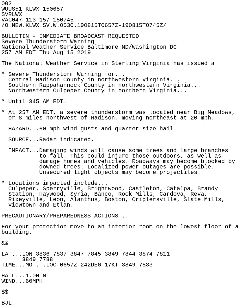
002
WUUS51 KLWX 150657
SVRLWX
VAC047-113-157-150745-
/O.NEW.KLWX.SV.W.0530.190815T0657Z-190815T0745Z/

BULLETIN - IMMEDIATE BROADCAST REQUESTED
Severe Thunderstorm Warning
National Weather Service Baltimore MD/Washington DC
257 AM EDT Thu Aug 15 2019

The National Weather Service in Sterling Virginia has issued a

* Severe Thunderstorm Warning for...
  Central Madison County in northwestern Virginia...
  Southern Rappahannock County in northwestern Virginia...
  Northwestern Culpeper County in northern Virginia...

* Until 345 AM EDT.

* At 257 AM EDT, a severe thunderstorm was located near Big Meadows,
  or 8 miles northwest of Madison, moving northeast at 20 mph.

  HAZARD...60 mph wind gusts and quarter size hail.

  SOURCE...Radar indicated.

  IMPACT...Damaging winds will cause some trees and large branches
           to fall. This could injure those outdoors, as well as
           damage homes and vehicles. Roadways may become blocked by
           downed trees. Localized power outages are possible.
           Unsecured light objects may become projectiles.

* Locations impacted include...
  Culpeper, Sperryville, Brightwood, Castleton, Catalpa, Brandy
  Station, Haywood, Syria, Banco, Rock Mills, Cardova, Reva,
  Rixeyville, Leon, Alanthus, Boston, Criglersville, Slate Mills,
  Viewtown and Etlan.

PRECAUTIONARY/PREPAREDNESS ACTIONS...

For your protection move to an interior room on the lowest floor of a
building.

&&

LAT...LON 3836 7837 3847 7845 3849 7844 3874 7811
      3849 7788
TIME...MOT...LOC 0657Z 242DEG 17KT 3849 7833

HAIL...1.00IN
WIND...60MPH

$$

BJL