National Weather Service Raw Text Product
Displaying AFOS PIL: PNSGSP Product Timestamp: 2019-04-22 22:31 UTC
Previous in Time Latest Product Next in Time
View All KGSP Products for 22 Apr 2019 View All PNS Products for 22 Apr 2019 View As Image Download As Text
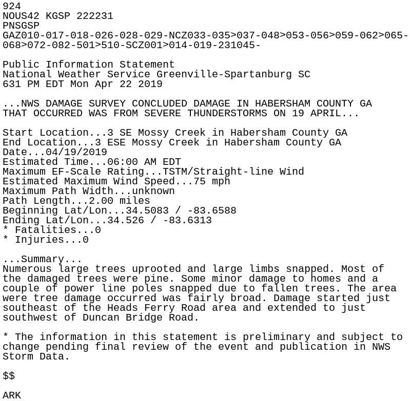
924
NOUS42 KGSP 222231
PNSGSP
GAZ010-017-018-026-028-029-NCZ033-035>037-048>053-056>059-062>065-
068>072-082-501>510-SCZ001>014-019-231045-

Public Information Statement
National Weather Service Greenville-Spartanburg SC
631 PM EDT Mon Apr 22 2019

...NWS DAMAGE SURVEY CONCLUDED DAMAGE IN HABERSHAM COUNTY GA
THAT OCCURRED WAS FROM SEVERE THUNDERSTORMS ON 19 APRIL...

Start Location...3 SE Mossy Creek in Habersham County GA
End Location...3 ESE Mossy Creek in Habersham County GA
Date...04/19/2019
Estimated Time...06:00 AM EDT
Maximum EF-Scale Rating...TSTM/Straight-line Wind
Estimated Maximum Wind Speed...75 mph
Maximum Path Width...unknown
Path Length...2.00 miles
Beginning Lat/Lon...34.5083 / -83.6588
Ending Lat/Lon...34.526 / -83.6313
* Fatalities...0
* Injuries...0

...Summary...
Numerous large trees uprooted and large limbs snapped. Most of
the damaged trees were pine. Some minor damage to homes and a
couple of power line poles snapped due to fallen trees. The area
were tree damage occurred was fairly broad. Damage started just
southeast of the Heads Ferry Road area and extended to just
southwest of Duncan Bridge Road.

* The information in this statement is preliminary and subject to
change pending final review of the event and publication in NWS
Storm Data.

$$

ARK