National Weather Service Raw Text Product
Displaying AFOS PIL: PNSLIX Product Timestamp: 2019-04-15 21:19 UTC
Previous in Time Latest Product Next in Time
View All KLIX Products for 15 Apr 2019 View All PNS Products for 15 Apr 2019 View As Image Download As Text
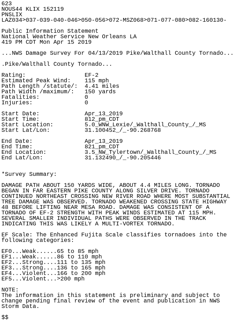
623
NOUS44 KLIX 152119
PNSLIX
LAZ034>037-039-040-046>050-056>072-MSZ068>071-077-080>082-160130-

Public Information Statement
National Weather Service New Orleans LA
419 PM CDT Mon Apr 15 2019

...NWS Damage Survey For 04/13/2019 Pike/Walthall County Tornado...

.Pike/Walthall County Tornado...

Rating:                 EF-2
Estimated Peak Wind:    115 mph
Path Length /statute/:  4.41 miles
Path Width /maximum/:   150 yards
Fatalities:             0
Injuries:               0

Start Date:             Apr_13_2019
Start Time:             812_pm_CDT
Start Location:         5.0_WNW_Lexie/_Walthall_County_/_MS
Start Lat/Lon:          31.100452_/_-90.268768

End Date:               Apr_13_2019
End Time:               821_pm_CDT
End Location:           3.5_NW_Tylertown/_Walthall_County_/_MS
End Lat/Lon:            31.132490_/_-90.205446


*Survey Summary:

DAMAGE PATH ABOUT 150 YARDS WIDE, ABOUT 4.4 MILES LONG. TORNADO
BEGAN IN FAR EASTERN PIKE COUNTY ALONG SILVER DRIVE. TORNADO
CONTINUED NORTHEAST CROSSING NEW RIVER ROAD WHERE MOST SUBSTANTIAL
TREE DAMAGE WAS OBSERVED. TORNADO WEAKENED CROSSING STATE HIGHWAY
48 BEFORE LIFTING NEAR MESA ROAD. DAMAGE WAS CONSISTENT OF A
TORNADO OF EF-2 STRENGTH WITH PEAK WINDS ESTIMATED AT 115 MPH.
SEVERAL SMALLER INDIVIDUAL PATHS WERE OBSERVED IN THE TRACK
INDICATING THIS WAS LIKELY A MULTI-VORTEX TORNADO.

EF Scale: The Enhanced Fujita Scale classifies tornadoes into the
following categories:

EF0...Weak......65 to 85 mph
EF1...Weak......86 to 110 mph
EF2...Strong....111 to 135 mph
EF3...Strong....136 to 165 mph
EF4...Violent...166 to 200 mph
EF5...Violent...>200 mph

NOTE:
The information in this statement is preliminary and subject to
change pending final review of the event and publication in NWS
Storm Data.

$$