National Weather Service Raw Text Product
Displaying AFOS PIL: EWWTBW Product Timestamp: 2017-09-11 03:14 UTC
Previous in Time Latest Product Next in Time
View All KTBW Products for 11 Sep 2017 View All EWW Products for 11 Sep 2017 View As Image Download As Text
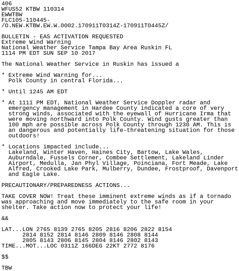
406
WFUS52 KTBW 110314
EWWTBW
FLC105-110445-
/O.NEW.KTBW.EW.W.0002.170911T0314Z-170911T0445Z/

BULLETIN - EAS ACTIVATION REQUESTED
Extreme Wind Warning
National Weather Service Tampa Bay Area Ruskin FL
1114 PM EDT SUN SEP 10 2017

The National Weather Service in Ruskin has issued a

* Extreme Wind Warning for...
  Polk County in central Florida...

* Until 1245 AM EDT

* At 1111 PM EDT, National Weather Service Doppler radar and
  emergency management in Hardee County indicated a core of very
  strong winds, associated with the eyewall of Hurricane Irma that
  were moving northward into Polk County. Wind gusts greater than
  100 mph are possible across Polk County through 1230 AM. This is
  an dangerous and potentially life-threatening situation for those
  outdoors!

* Locations impacted include...
  Lakeland, Winter Haven, Haines City, Bartow, Lake Wales,
  Auburndale, Fussels Corner, Combee Settlement, Lakeland Linder
  Airport, Medulla, Jan Phyl Village, Poinciana, Fort Meade, Lake
  Alfred, Crooked Lake Park, Mulberry, Dundee, Frostproof, Davenport
  and Eagle Lake.

PRECAUTIONARY/PREPAREDNESS ACTIONS...

TAKE COVER NOW! Treat these imminent extreme winds as if a tornado
was approaching and move immediately to the safe room in your
shelter. Take action now to protect your life!

&&

LAT...LON 2765 8139 2765 8205 2816 8206 2822 8154
      2814 8152 2814 8146 2809 8146 2808 8144
      2805 8143 2806 8145 2804 8146 2802 8143
TIME...MOT...LOC 0311Z 166DEG 22KT 2772 8176

$$

TBW