National Weather Service Raw Text Product
Displaying AFOS PIL: SPSTBW Product Timestamp: 2025-06-23 22:36 UTC
Previous in Time Latest Product Next in Time
View All KTBW Products for 23 Jun 2025 View All SPS Products for 23 Jun 2025 View As Image Download As Text
195
WWUS82 KTBW 232236
SPSTBW
Special Weather Statement
National Weather Service Tampa Bay Area Ruskin FL
636 PM EDT Mon Jun 23 2025
FLZ139-232300-
Coastal Levy FL-
636 PM EDT Mon Jun 23 2025
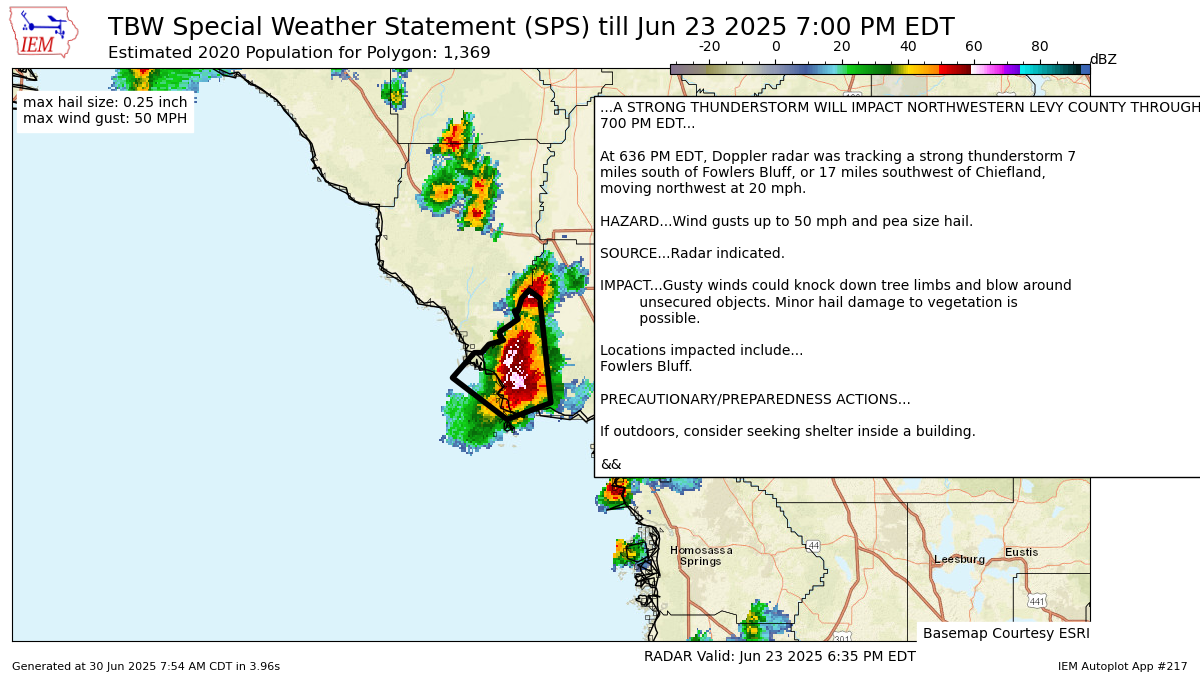
...A STRONG THUNDERSTORM WILL IMPACT NORTHWESTERN LEVY COUNTY THROUGH
700 PM EDT...
At 636 PM EDT, Doppler radar was tracking a strong thunderstorm 7
miles south of Fowlers Bluff, or 17 miles southwest of Chiefland,
moving northwest at 20 mph.
HAZARD...Wind gusts up to 50 mph and pea size hail.
SOURCE...Radar indicated.
IMPACT...Gusty winds could knock down tree limbs and blow around
unsecured objects. Minor hail damage to vegetation is
possible.
Locations impacted include...
Fowlers Bluff.
PRECAUTIONARY/PREPAREDNESS ACTIONS...
If outdoors, consider seeking shelter inside a building.
&&
LAT...LON 2926 8320 2932 8314 2932 8312 2934 8310
2935 8306 2936 8307 2937 8307 2940 8302
2942 8303 2942 8302 2945 8301 2947 8299
2945 8296 2920 8293 2916 8305
TIME...MOT...LOC 2236Z 134DEG 19KT 2928 8304
MAX HAIL SIZE...0.25 IN
MAX WIND GUST...50 MPH
$$
TBW
Autoplot 217 generated the following image below. You may find more customization options , like removal of RADAR, for this image by visiting that autoplot.
