National Weather Service Raw Text Product
Displaying AFOS PIL: SPSBRO Product Timestamp: 2025-06-21 17:56 UTC
Previous in Time Latest Product Next in Time
View All KBRO Products for 21 Jun 2025 View All SPS Products for 21 Jun 2025 View As Image Download As Text
782
WWUS84 KBRO 211756
SPSBRO
Special Weather Statement
National Weather Service Brownsville TX
1256 PM CDT Sat Jun 21 2025
TXZ255-355-211845-
Coastal Cameron TX-Inland Cameron TX-
1256 PM CDT Sat Jun 21 2025
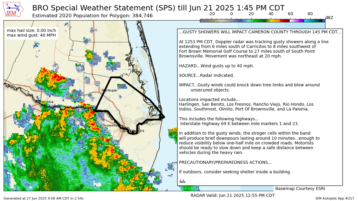
...GUSTY SHOWERS WILL IMPACT CAMERON COUNTY THROUGH 145 PM CDT...
At 1253 PM CDT, Doppler radar was tracking gusty showers along a line
extending from 6 miles south of Carricitos to 8 miles southwest of
Fort Brown Memorial Golf Course to 27 miles south of South Point
Brownsville. Movement was northeast at 20 mph.
HAZARD...Wind gusts up to 40 mph.
SOURCE...Radar indicated.
IMPACT...Gusty winds could knock down tree limbs and blow around
unsecured objects.
Locations impacted include...
Harlingen, San Benito, Los Fresnos, Rancho Viejo, Rio Hondo, Los
Indios, Southmost, Olmito, Port Of Brownsville, and La Paloma.
This includes the following highways...
Interstate Highway 69 E between mile markers 1 and 23.
In addition to the gusty winds, the stroger cells within the band
will produce brief downpours lasting around 10 minutes...enough to
reduce visibility below one-half mile on crowded roads. Motorists
should be ready to slow down and keep a safe distance between
vehicles during the heavy rain.
PRECAUTIONARY/PREPAREDNESS ACTIONS...
If outdoors, consider seeking shelter inside a building.
&&
LAT...LON 2598 9712 2597 9714 2600 9716 2596 9716
2596 9728 2592 9733 2593 9735 2591 9737
2585 9737 2584 9740 2586 9741 2584 9741
2585 9745 2588 9746 2589 9752 2603 9764
2603 9776 2631 9761 2631 9753 2612 9725
TIME...MOT...LOC 1753Z 216DEG 18KT 2595 9773 2577 9755 2550 9723
MAX HAIL SIZE...0.00 IN
MAX WIND GUST...40 MPH
$$
52-BSG
Autoplot 217 generated the following image below. You may find more customization options , like removal of RADAR, for this image by visiting that autoplot.
