National Weather Service Raw Text Product
Displaying AFOS PIL: SPSPAH Product Timestamp: 2025-06-05 01:01 UTC
Previous in Time Latest Product Next in Time
View All KPAH Products for 05 Jun 2025 View All SPS Products for 05 Jun 2025 View As Image Download As Text
877
WWUS83 KPAH 050101
SPSPAH
Special Weather Statement
National Weather Service Paducah KY
801 PM CDT Wed Jun 4 2025
ILZ086-090-050115-
Saline IL-Pope IL-
801 PM CDT Wed Jun 4 2025
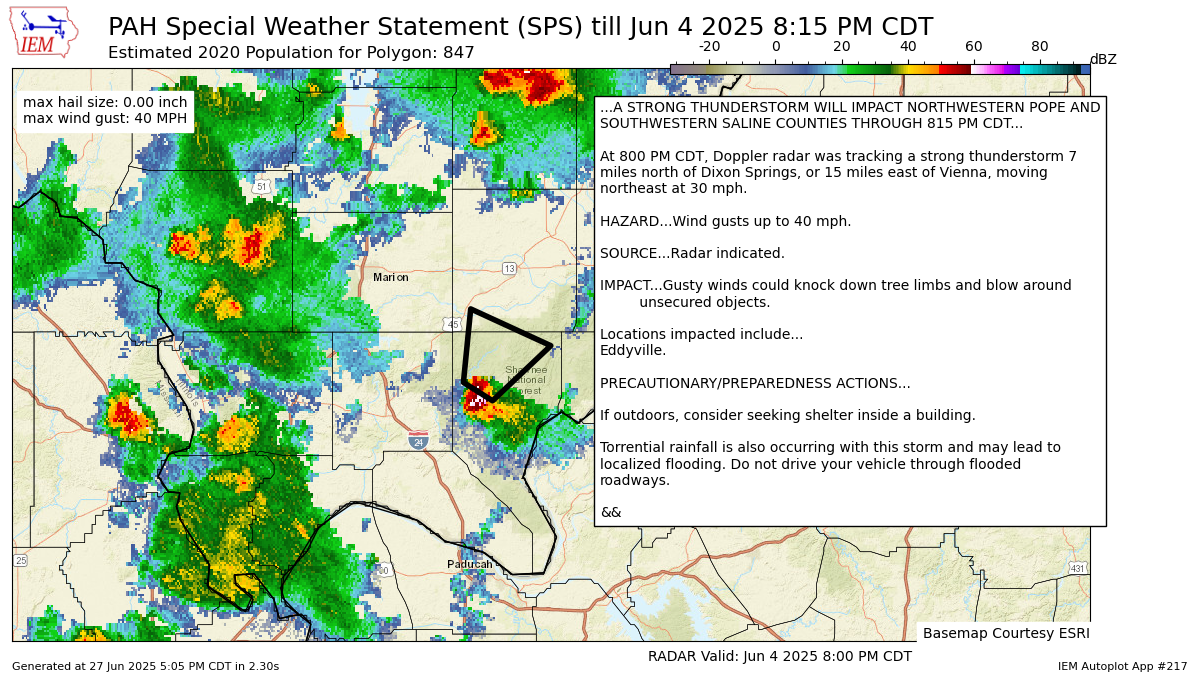
...A STRONG THUNDERSTORM WILL IMPACT NORTHWESTERN POPE AND
SOUTHWESTERN SALINE COUNTIES THROUGH 815 PM CDT...
At 800 PM CDT, Doppler radar was tracking a strong thunderstorm 7
miles north of Dixon Springs, or 15 miles east of Vienna, moving
northeast at 30 mph.
HAZARD...Wind gusts up to 40 mph.
SOURCE...Radar indicated.
IMPACT...Gusty winds could knock down tree limbs and blow around
unsecured objects.
Locations impacted include...
Eddyville.
PRECAUTIONARY/PREPAREDNESS ACTIONS...
If outdoors, consider seeking shelter inside a building.
Torrential rainfall is also occurring with this storm and may lead to
localized flooding. Do not drive your vehicle through flooded
roadways.
&&
LAT...LON 3745 8860 3749 8868 3765 8866 3757 8844
TIME...MOT...LOC 0100Z 203DEG 24KT 3749 8862
MAX HAIL SIZE...0.00 IN
MAX WIND GUST...40 MPH
$$
SHAWKEY
Autoplot 217 generated the following image below. You may find more customization options , like removal of RADAR, for this image by visiting that autoplot.
