National Weather Service Raw Text Product
Displaying AFOS PIL: SVSDMX Product Timestamp: 2025-04-29 01:41 UTC
Previous in Time Latest Product Next in Time
View All KDMX Products for 29 Apr 2025 View All SVS Products for 29 Apr 2025 View As Image Download As Text
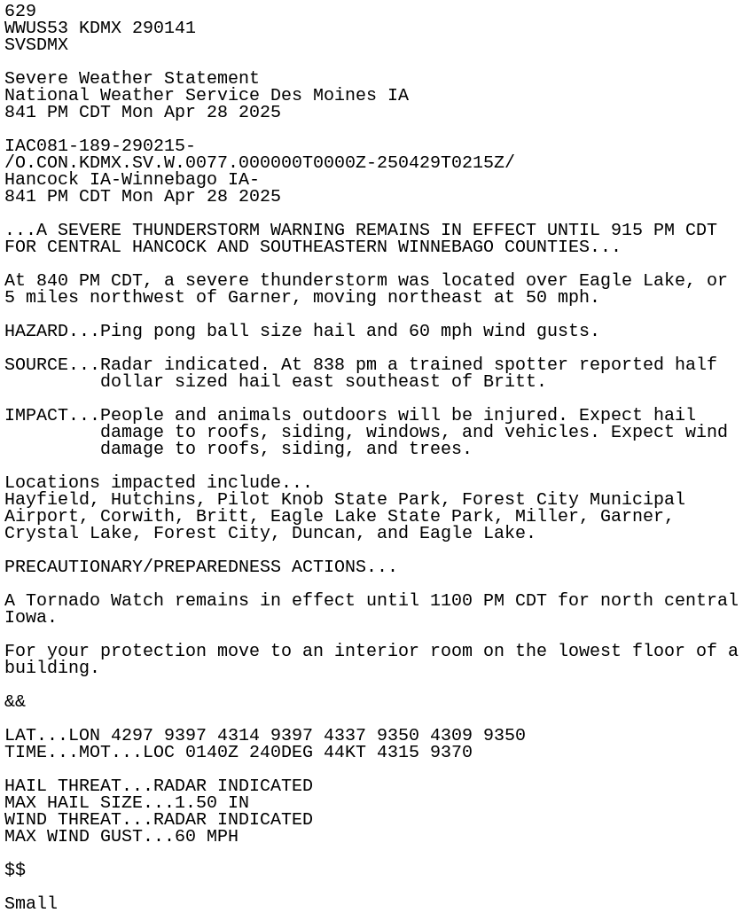
629
WWUS53 KDMX 290141
SVSDMX

Severe Weather Statement
National Weather Service Des Moines IA
841 PM CDT Mon Apr 28 2025

IAC081-189-290215-
/O.CON.KDMX.SV.W.0077.000000T0000Z-250429T0215Z/
Hancock IA-Winnebago IA-
841 PM CDT Mon Apr 28 2025

...A SEVERE THUNDERSTORM WARNING REMAINS IN EFFECT UNTIL 915 PM CDT
FOR CENTRAL HANCOCK AND SOUTHEASTERN WINNEBAGO COUNTIES...

At 840 PM CDT, a severe thunderstorm was located over Eagle Lake, or
5 miles northwest of Garner, moving northeast at 50 mph.

HAZARD...Ping pong ball size hail and 60 mph wind gusts.

SOURCE...Radar indicated. At 838 pm a trained spotter reported half
         dollar sized hail east southeast of Britt.

IMPACT...People and animals outdoors will be injured. Expect hail
         damage to roofs, siding, windows, and vehicles. Expect wind
         damage to roofs, siding, and trees.

Locations impacted include...
Hayfield, Hutchins, Pilot Knob State Park, Forest City Municipal
Airport, Corwith, Britt, Eagle Lake State Park, Miller, Garner,
Crystal Lake, Forest City, Duncan, and Eagle Lake.

PRECAUTIONARY/PREPAREDNESS ACTIONS...

A Tornado Watch remains in effect until 1100 PM CDT for north central
Iowa.

For your protection move to an interior room on the lowest floor of a
building.

&&

LAT...LON 4297 9397 4314 9397 4337 9350 4309 9350
TIME...MOT...LOC 0140Z 240DEG 44KT 4315 9370

HAIL THREAT...RADAR INDICATED
MAX HAIL SIZE...1.50 IN
WIND THREAT...RADAR INDICATED
MAX WIND GUST...60 MPH

$$

Small