National Weather Service Raw Text Product
Displaying AFOS PIL: SVRDMX Product Timestamp: 2025-03-14 22:54 UTC
Previous in Time Latest Product Next in Time
View All KDMX Products for 14 Mar 2025 View All SVR Products for 14 Mar 2025 View As Image Download As Text
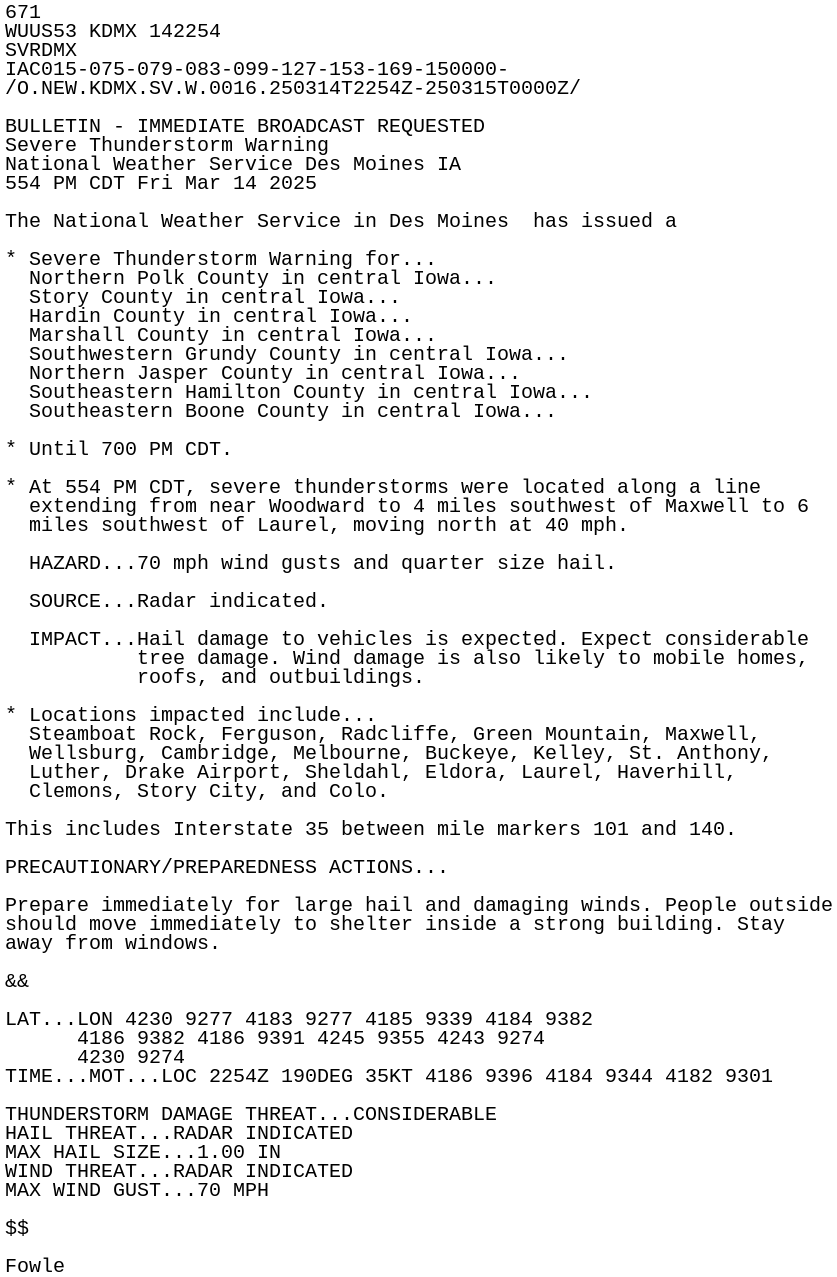
671
WUUS53 KDMX 142254
SVRDMX
IAC015-075-079-083-099-127-153-169-150000-
/O.NEW.KDMX.SV.W.0016.250314T2254Z-250315T0000Z/

BULLETIN - IMMEDIATE BROADCAST REQUESTED
Severe Thunderstorm Warning
National Weather Service Des Moines IA
554 PM CDT Fri Mar 14 2025

The National Weather Service in Des Moines  has issued a

* Severe Thunderstorm Warning for...
  Northern Polk County in central Iowa...
  Story County in central Iowa...
  Hardin County in central Iowa...
  Marshall County in central Iowa...
  Southwestern Grundy County in central Iowa...
  Northern Jasper County in central Iowa...
  Southeastern Hamilton County in central Iowa...
  Southeastern Boone County in central Iowa...

* Until 700 PM CDT.

* At 554 PM CDT, severe thunderstorms were located along a line
  extending from near Woodward to 4 miles southwest of Maxwell to 6
  miles southwest of Laurel, moving north at 40 mph.

  HAZARD...70 mph wind gusts and quarter size hail.

  SOURCE...Radar indicated.

  IMPACT...Hail damage to vehicles is expected. Expect considerable
           tree damage. Wind damage is also likely to mobile homes,
           roofs, and outbuildings.

* Locations impacted include...
  Steamboat Rock, Ferguson, Radcliffe, Green Mountain, Maxwell,
  Wellsburg, Cambridge, Melbourne, Buckeye, Kelley, St. Anthony,
  Luther, Drake Airport, Sheldahl, Eldora, Laurel, Haverhill,
  Clemons, Story City, and Colo.

This includes Interstate 35 between mile markers 101 and 140.

PRECAUTIONARY/PREPAREDNESS ACTIONS...

Prepare immediately for large hail and damaging winds. People outside
should move immediately to shelter inside a strong building. Stay
away from windows.

&&

LAT...LON 4230 9277 4183 9277 4185 9339 4184 9382
      4186 9382 4186 9391 4245 9355 4243 9274
      4230 9274
TIME...MOT...LOC 2254Z 190DEG 35KT 4186 9396 4184 9344 4182 9301

THUNDERSTORM DAMAGE THREAT...CONSIDERABLE
HAIL THREAT...RADAR INDICATED
MAX HAIL SIZE...1.00 IN
WIND THREAT...RADAR INDICATED
MAX WIND GUST...70 MPH

$$

Fowle